Our weather thankfully is quiet for Christmas Eve and Christmas Day with lightening winds and tolerable temperatures. Santa also won’t have any issues to make all of his stops! However, things turn much more interesting right after the Christmas holiday as we are tracking a winter storm that looks to bring a mixed bag of precipitation to the region later Friday into at least early Saturday morning.
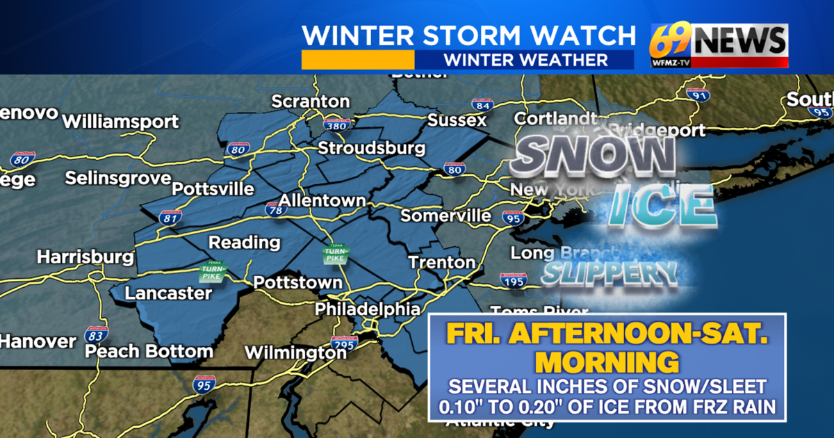
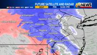
The National Weather Service has placed the large majority of our region under a Winter Storm WATCH from Friday afternoon through Saturday morning for the potential of several inches of snow and sleet along with a little bit of ice accumulation from freezing rain.


For many, the precipitation is expected to start out as all snow moving in from west to east roughly between 3pm and 6pm on Friday. That initial round of snow could pick up in intensity fairly quickly. Then, roughly between 8pm and midnight, we anticipate a change to sleet from west to east with the change to sleet probably stopping somewhere near the Delaware River. This sleet will likely continue for an extended period of time overnight Friday before tapering off early Saturday morning, probably before 10am.
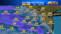
Some freezing rain (plain rain falling from the sky that freezes on contact with sub-freezing surfaces creating layers of ice) may also mix in with the sleet Friday night into Saturday morning. The further south and west one travels from the I-78 corridor, the better your odds will be to see that freezing rain. At this time, ice totals likely will be on the order of 0.10″ to 0.20″ and again, the further south and west one travels from the I-78 corridor, the greater the amounts would be.
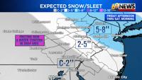
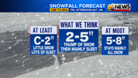
Now as for expected snow/sleet totals, for much of the Lehigh Valley, Berks, Schuylkill, Bucks and Montgomery counties, the Delaware Valley, southwestern New Jersey, and even the western Poconos closer to I-476 and I-81, we anticipate 2 to 5 inches of accumulation with sleet and possibly some freezing rain keeping totals from getting higher than 5 inches. If some of these areas do manage to remain mostly all snow, then totals could possibly exceed 5 inches. For those in the Slate Belt region, eastern Poconos…certainly Monroe and Pike County, and a lot of central and northern New Jersey, we anticipate the precipitation to stay mainly all snow and hence the greatest totals on the order of 5 to 8 inches are expected here.
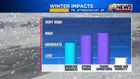
Temperatures during this storm system will be below freezing in most locations, mainly in the 20s and certainly no warmer than 30 degrees. So whatever precipitation falls will definitely stick, and road conditions and untreated surfaces will certainly have deteriorating conditions by Friday evening through much of the overnight into first thing Saturday morning.
Temperatures will briefly turn milder on Sunday with a decent bout of rain expected late Sunday into Sunday night. This will help to wash away some of the snow/ice that falls prior. After that storm system though, we expect an extended stretch of bitterly cold arctic air to build back into the region setting us up for a cold start to 2026!