
Merry Christmas from the News 8 Storm Team!A quick-moving low pressure system will bring a few showers to Franklin, Adams, Cumberland, and York Counties this morning. Otherwise, expect clouds to start, then clearing. We’ll see partly sunny skies this afternoon, with mild highs in the upper 40s. Some areas might get close to 50 degrees! Winds will be light this morning, then increase slightly this afternoon.Tonight, mostly clear skies are in store, with lows in the mid-20s. Clouds will increase toward sunrise Friday.ALERT FRIDAY: WIDESPREAD WINTRY MIXA Winter Storm Watch is in effect for the Susquehanna Valley Friday through Friday night. Snow and sleet accumulations of a coating to 2″, and 0.10″ to 0.20″ of freezing rain is expected.Low pressure will pass to our south on Friday, while high pressure presses in from the northeast. This will lead to a wintry mix developing by early afternoon. Arrival time is 1 to 5 p.m. from west to east.Initially, precipitation will fall as light snow in most areas, then as warmer air moves into the lower levels of the atmosphere, sleet and freezing rain will develop. Most areas will have an icy mix by evening, and sleet and freezing rain will continue until about 3 a.m. Saturday. Precipitation will be gone by sunrise Saturday.Highs will hover near freezing on Friday, then fall to the upper 20s Friday night. Travel conditions will deteriorate by late Friday afternoon, so getting to your destination early Friday afternoon is the best bet!IMPACT SATURDAY:Saturday will be dry and chilly under mostly cloudy skies. Highs will reach the low 30s. Please be mindful that icy conditions will last through Saturday morning, because temperatures will be slow to warm. Untreated surfaces will likely remain icy through late morning.A chance of rain returns late Sunday, as highs climb to the upper 30s.Get ready for a cold blast to end 2025! A strong cold front will pass Monday afternoon, leading to rain in the morning, then windy conditions in the afternoon and evening. Highs will hit the low 40s early Monday, then fall to 30 degrees Tuesday, and the low-30s Wednesday.Another front will take aim at the region on New Year’s Day, keeping highs in the low-to-mid 30s through the end of the week. Wind chills will range from the teens to 20s most days.
Merry Christmas from the News 8 Storm Team!
A quick-moving low pressure system will bring a few showers to Franklin, Adams, Cumberland, and York Counties this morning. Otherwise, expect clouds to start, then clearing. We’ll see partly sunny skies this afternoon, with mild highs in the upper 40s. Some areas might get close to 50 degrees! Winds will be light this morning, then increase slightly this afternoon.
Tonight, mostly clear skies are in store, with lows in the mid-20s. Clouds will increase toward sunrise Friday.
ALERT FRIDAY: WIDESPREAD WINTRY MIX
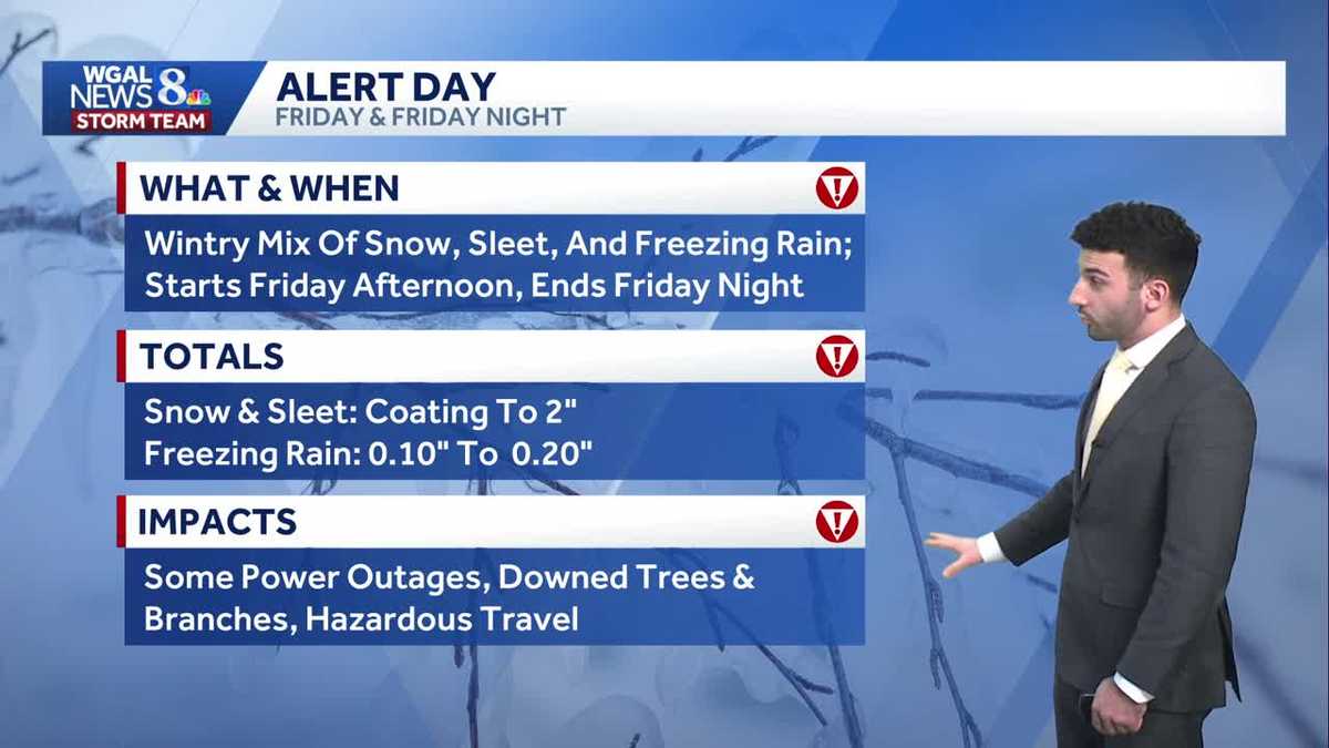
A Winter Storm Watch is in effect for the Susquehanna Valley Friday through Friday night. Snow and sleet accumulations of a coating to 2″, and 0.10″ to 0.20″ of freezing rain is expected.
Low pressure will pass to our south on Friday, while high pressure presses in from the northeast. This will lead to a wintry mix developing by early afternoon. Arrival time is 1 to 5 p.m. from west to east.
Initially, precipitation will fall as light snow in most areas, then as warmer air moves into the lower levels of the atmosphere, sleet and freezing rain will develop. Most areas will have an icy mix by evening, and sleet and freezing rain will continue until about 3 a.m. Saturday. Precipitation will be gone by sunrise Saturday.
Highs will hover near freezing on Friday, then fall to the upper 20s Friday night. Travel conditions will deteriorate by late Friday afternoon, so getting to your destination early Friday afternoon is the best bet!
IMPACT SATURDAY:
Saturday will be dry and chilly under mostly cloudy skies. Highs will reach the low 30s. Please be mindful that icy conditions will last through Saturday morning, because temperatures will be slow to warm. Untreated surfaces will likely remain icy through late morning.
A chance of rain returns late Sunday, as highs climb to the upper 30s.
Get ready for a cold blast to end 2025! A strong cold front will pass Monday afternoon, leading to rain in the morning, then windy conditions in the afternoon and evening. Highs will hit the low 40s early Monday, then fall to 30 degrees Tuesday, and the low-30s Wednesday.
Another front will take aim at the region on New Year’s Day, keeping highs in the low-to-mid 30s through the end of the week. Wind chills will range from the teens to 20s most days.