
Western Pennsylvania Severe Weather Alert: Ice on roads Friday means treacherous travel day
Rain, sleet, freezing rain, and snow are all possible Friday.
ACTIONS. A WARM CHRISTMAS DAY IN STORE FOR US, AS TEMPERATURES WILL BE ABOUT TEN DEGREES ABOVE WHERE WE SHOULD BE FOR THIS TIME OF YEAR. TOMORROW, THOUGH, IS THE DAY WE’RE WATCHING. IT IS A SEVERE WEATHER ALERT DAY. WE’LL SEE RAIN SHOWERS AND ICY CONDITIONS, ESPECIALLY NORTH AND EAST OF PITTSBURGH, AND WE’LL STAY MILD AS WE HEAD INTO THE FINAL WEEKEND OF THE YEAR. WITH RAIN RETURNING AS WE CLOSE OUT THE WEEKEND AS WELL. A WINTER STORM WATCH REMAINS IN EFFECT FOR COUNTIES NORTH AND EAST OF PITTSBURGH, INCLUDING THE LAUREL HIGHLANDS, AND NORTH OF 422, EXCEPT FOR BUTLER AND LAWRENCE COUNTIES. WE WILL SEE THIS UPGRADED AT SOME POINT TODAY IN ADVANCE OF OUR SYSTEM THAT GETS HERE TOMORROW. THE WIDESPREAD, HEAVIER RAIN THAT WE SAW THIS MORNING HAS EXITED. A COUPLE LIGHT SPRINKLES, THOUGH, ARE LEFT OVER ACROSS WESTERN PENNSYLVANIA. BUT THOSE WILL CLEAR OUT HERE MOMENTARILY. AND WE’RE MAINLY DRY AS WE HEAD THROUGH THE REST OF CHRISTMAS DAY. WE’LL SEE SOME PEEKS OF SUNSHINE AS WE CLIMB THE 4842 TOMORROW ON OUR SEVERE WEATHER ALERT DAY, WITH RAIN SHOWERS AND A WINTRY MIX. SATURDAY WILL BE AT 40 SUNDAY. THEN WE’RE WATCHING OUR NEXT SYSTEM THAT BRINGS RAIN SHOWERS ACROSS THE AREA. RAIN WILL START ABOUT MID MORNING AND THEN LAST THROUGH THE DAY, SO ONCE IT STARTS RAINING IN YOUR LOCATION, IT’S GOING TO RAIN FOR THE REST OF YOUR SUNDAY SO ROADS WILL BE WET. AND IF YOU ARE TRAVELING ON SUNDAY, IT’S GOING TO BE RAINY. BUT IF YOU CAN AVOID OBVIOUSLY FRIDAY BECAUSE IT’S SEVERE WEATHER ALERT DAY AND SUNDAY, SATURDAY IS THE PICK FOR TRAVEL THIS WEEKEND. ON MONDAY, OUR TEMPERATURES WILL FALL THAT 48 AT ABOUT MIDNIGHT. RAIN SHOWERS WILL BE WITH US FOR THE MORNING COMMUTE, BUT THEN TRANSITION TO SNOWFLAKES AS WE HEAD THROUGH THE AFTERNOON. AS OUR TEMPERATURES FALL. WE’RE NOT EXPECTING MUCH ACCUMULATION OUT OF THIS, THOUGH. AN INCH OR LESS ACROSS WESTERN PENNSYLVANIA. WHAT IT DOES IS USHER IN THE COLDER AIR. WE’RE IN THE 20S FOR HIGHS ON TUESDAY, 32 ON NEW YEAR’S EVE, 34 ON NEW YEAR’S DAY WITH TEMPERATURES AT THE START OF EACH DAY RIGHT AROUND 20 DEGREES. SO IT’S GOING TO BE COLD FOR FIRST NIGHT, BUT NO SNOW OR RAIN TO WORRY ABOUT. LET’S START FUTURECAST FOR YOU. TOMORROW MORNING WE’LL BE SEEING THE FIRST BATCHES OF SOME FREEZING RAIN, WHICH COULD IMPACT THE CITY AS WELL AS THIS STARTS. THE CITY THOUGH WILL WARM UP AND WILL QUICKLY TRANSITION TO RAIN FOR MOST OF ALLEGHENY COUNTY, NORTH AND EAST OF ALLEGHENY COUNTIES, WHERE WE’LL SEE LIKELY FREEZING RAIN FOR A GOOD PORTION OF YOUR FRIDAY SOUTH OF THE CITY SHOULD BE ALL RAIN FOR THE EVENT. AGAIN, THAT FREEZING RAIN CONTINUES INTO FRIDAY EVENING BEFORE THINGS BEGIN TAPERING OFF. ONCE WE GET PAST SUNSET. SO WE’RE TALKING SEVERAL HOURS OF FREEZING RAIN POSSIBLE THAT COULD LEAD TO SOME SIGNIFICANT ICE ACCUMULATIONS NORTH AND EAST OF PITTSBURGH, A 10TH OF AN INCH IS ENOUGH TO CAUSE PROBLEMS ON ROADS. AS YOU GET TO A QUARTER TO A HALF AN INCH OF FREEZING RAIN THAT COULD BRING DOWN POWER LINES AND TREE LIMBS. SO VERY DANGEROUS SITUATION FOR US NORTH AND EAST OF PITTSBURGH AND INTO THE LAUREL HIGHLANDS. SO IF YOU DON’T HAVE TO TRAVEL ON FRIDAY, IT’S BEST NOT TO. LOW CLOUDS FOR US THIS MORNING ON ACTION CAM. LEFTOVER FROM THE RAIN THAT PASSED THROUGH EARLIER 38 IS THE CURRENT TEMPERATURE AT PITTSBURGH. INTERNATIONAL WINDS ARE LIGHT AND THEY’LL BE LIGHT THROUGH THE DAY TODAY. AND LITTLE BIT OF SUNSHINE WE GET WILL HELP TO BUMP US BACK INTO THE UPPER 40S LATER ON TODAY. AGAIN, THAT’S TEN DEGREES ABOVE WHERE WE SHOULD BE FOR THIS TIME OF YEAR. FRIDAY AGAIN, THAT SEVERE WEATHER ALERT DAY. IF YOU HAVE TO TRAVEL FRIDAY, THE EARLIER THE BETTER. IF YOU CAN WAIT UNTIL SATUR
Western Pennsylvania Severe Weather Alert: Ice on roads Friday means treacherous travel day
Rain, sleet, freezing rain, and snow are all possible Friday.

Updated: 1:12 PM EST Dec 25, 2025
Our next system arrives Friday to bring dangerous travel to parts of Western PA. Friday – Severe Weather Alert DayOur next major system is here Friday to bring all the winter precipitation types. Precipitation will likely start Friday morning, after the commute, as brief snow and freezing rain for Pittsburgh and locations north and east. For locations south of US 422, we should see a fairly quick change to all rain. Ice accretion of less than 0.1″ is expected here, but we could see some slick spots on bridges, overpasses, and untreated surfaces.The more dangerous icing will happen north of US 422 and into the Laurel Highlands where precipitation could start as wet snowflakes before becoming freezing rain. The freezing rain could last for the entirety of the event, causing heavy ice accretion leading to dangerous travel conditions and possible power outages from power line and tree limb damage.Precipitation will come to an end after sunset with us drying out into Saturday morning.Colder to End 2025 with Rain and SnowSunday brings another system to Western PA with rain showers through most of the day. Rain will linger to start Monday, and as the cold front passes in the morning, temperatures will drop through the day. Rain will transition to snow through the afternoon Monday. Snow accumulations of less than an inch possible. We then turn cold to end 2025 as highs drop into the 20s and struggle to freezing by Christmas Day.FRIDAY – Severe Weather Alert Day: Freezing rain and snow to start with rain around the city and freezing rain north and east. High: 42°, low: 26°.SATURDAY: Mostly cloudy. High: 40°, low: 34°.
Our next system arrives Friday to bring dangerous travel to parts of Western PA.
Friday – Severe Weather Alert Day

Hearst Owned
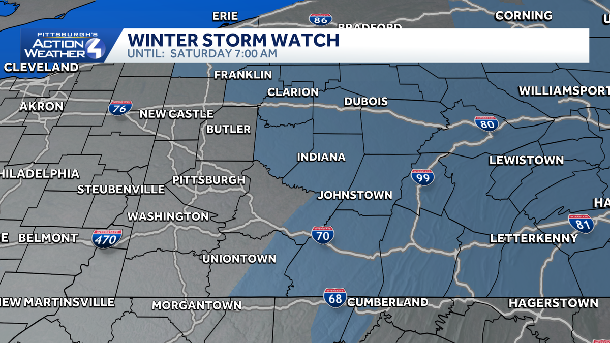
Winter Storm Watch north and east of Pittsburgh in advance of icing concerns Friday.
Our next major system is here Friday to bring all the winter precipitation types. Precipitation will likely start Friday morning, after the commute, as brief snow and freezing rain for Pittsburgh and locations north and east. For locations south of US 422, we should see a fairly quick change to all rain. Ice accretion of less than 0.1″ is expected here, but we could see some slick spots on bridges, overpasses, and untreated surfaces.

Hearst Owned
Rain and freezing rain will be location dependent Friday.
The more dangerous icing will happen north of US 422 and into the Laurel Highlands where precipitation could start as wet snowflakes before becoming freezing rain. The freezing rain could last for the entirety of the event, causing heavy ice accretion leading to dangerous travel conditions and possible power outages from power line and tree limb damage.

Hearst Owned
Icing amounts potentially up to half an inch, causing travel problems on Friday.
Precipitation will come to an end after sunset with us drying out into Saturday morning.
Colder to End 2025 with Rain and Snow
Sunday brings another system to Western PA with rain showers through most of the day. Rain will linger to start Monday, and as the cold front passes in the morning, temperatures will drop through the day. Rain will transition to snow through the afternoon Monday. Snow accumulations of less than an inch possible.
We then turn cold to end 2025 as highs drop into the 20s and struggle to freezing by Christmas Day.

Hearst Owned
Severe weather Alert Day Friday with significant icing possible. More rain and rain to snow for Sunday and Monday.
FRIDAY – Severe Weather Alert Day: Freezing rain and snow to start with rain around the city and freezing rain north and east. High: 42°, low: 26°.
SATURDAY: Mostly cloudy. High: 40°, low: 34°.