
ACTIONS. A WARM CHRISTMAS DAY IN STORE FOR US, AS TEMPERATURES WILL BE ABOUT TEN DEGREES ABOVE WHERE WE SHOULD BE FOR THIS TIME OF YEAR. TOMORROW, THOUGH, IS THE DAY WE’RE WATCHING. IT IS A SEVERE WEATHER ALERT DAY. WE’LL SEE RAIN SHOWERS AND ICY CONDITIONS, ESPECIALLY NORTH AND EAST OF PITTSBURGH, AND WE’LL STAY MILD AS WE HEAD INTO THE FINAL WEEKEND OF THE YEAR. WITH RAIN RETURNING AS WE CLOSE OUT THE WEEKEND AS WELL. A WINTER STORM WATCH REMAINS IN EFFECT FOR COUNTIES NORTH AND EAST OF PITTSBURGH, INCLUDING THE LAUREL HIGHLANDS, AND NORTH OF 422, EXCEPT FOR BUTLER AND LAWRENCE COUNTIES. WE WILL SEE THIS UPGRADED AT SOME POINT TODAY IN ADVANCE OF OUR SYSTEM THAT GETS HERE TOMORROW. THE WIDESPREAD, HEAVIER RAIN THAT WE SAW THIS MORNING HAS EXITED. A COUPLE LIGHT SPRINKLES, THOUGH, ARE LEFT OVER ACROSS WESTERN PENNSYLVANIA. BUT THOSE WILL CLEAR OUT HERE MOMENTARILY. AND WE’RE MAINLY DRY AS WE HEAD THROUGH THE REST OF CHRISTMAS DAY. WE’LL SEE SOME PEEKS OF SUNSHINE AS WE CLIMB THE 4842 TOMORROW ON OUR SEVERE WEATHER ALERT DAY, WITH RAIN SHOWERS AND A WINTRY MIX. SATURDAY WILL BE AT 40 SUNDAY. THEN WE’RE WATCHING OUR NEXT SYSTEM THAT BRINGS RAIN SHOWERS ACROSS THE AREA. RAIN WILL START ABOUT MID MORNING AND THEN LAST THROUGH THE DAY, SO ONCE IT STARTS RAINING IN YOUR LOCATION, IT’S GOING TO RAIN FOR THE REST OF YOUR SUNDAY SO ROADS WILL BE WET. AND IF YOU ARE TRAVELING ON SUNDAY, IT’S GOING TO BE RAINY. BUT IF YOU CAN AVOID OBVIOUSLY FRIDAY BECAUSE IT’S SEVERE WEATHER ALERT DAY AND SUNDAY, SATURDAY IS THE PICK FOR TRAVEL THIS WEEKEND. ON MONDAY, OUR TEMPERATURES WILL FALL THAT 48 AT ABOUT MIDNIGHT. RAIN SHOWERS WILL BE WITH US FOR THE MORNING COMMUTE, BUT THEN TRANSITION TO SNOWFLAKES AS WE HEAD THROUGH THE AFTERNOON. AS OUR TEMPERATURES FALL. WE’RE NOT EXPECTING MUCH ACCUMULATION OUT OF THIS, THOUGH. AN INCH OR LESS ACROSS WESTERN PENNSYLVANIA. WHAT IT DOES IS USHER IN THE COLDER AIR. WE’RE IN THE 20S FOR HIGHS ON TUESDAY, 32 ON NEW YEAR’S EVE, 34 ON NEW YEAR’S DAY WITH TEMPERATURES AT THE START OF EACH DAY RIGHT AROUND 20 DEGREES. SO IT’S GOING TO BE COLD FOR FIRST NIGHT, BUT NO SNOW OR RAIN TO WORRY ABOUT. LET’S START FUTURECAST FOR YOU. TOMORROW MORNING WE’LL BE SEEING THE FIRST BATCHES OF SOME FREEZING RAIN, WHICH COULD IMPACT THE CITY AS WELL AS THIS STARTS. THE CITY THOUGH WILL WARM UP AND WILL QUICKLY TRANSITION TO RAIN FOR MOST OF ALLEGHENY COUNTY, NORTH AND EAST OF ALLEGHENY COUNTIES, WHERE WE’LL SEE LIKELY FREEZING RAIN FOR A GOOD PORTION OF YOUR FRIDAY SOUTH OF THE CITY SHOULD BE ALL RAIN FOR THE EVENT. AGAIN, THAT FREEZING RAIN CONTINUES INTO FRIDAY EVENING BEFORE THINGS BEGIN TAPERING OFF. ONCE WE GET PAST SUNSET. SO WE’RE TALKING SEVERAL HOURS OF FREEZING RAIN POSSIBLE THAT COULD LEAD TO SOME SIGNIFICANT ICE ACCUMULATIONS NORTH AND EAST OF PITTSBURGH, A 10TH OF AN INCH IS ENOUGH TO CAUSE PROBLEMS ON ROADS. AS YOU GET TO A QUARTER TO A HALF AN INCH OF FREEZING RAIN THAT COULD BRING DOWN POWER LINES AND TREE LIMBS. SO VERY DANGEROUS SITUATION FOR US NORTH AND EAST OF PITTSBURGH AND INTO THE LAUREL HIGHLANDS. SO IF YOU DON’T HAVE TO TRAVEL ON FRIDAY, IT’S BEST NOT TO. LOW CLOUDS FOR US THIS MORNING ON ACTION CAM. LEFTOVER FROM THE RAIN THAT PASSED THROUGH EARLIER 38 IS THE CURRENT TEMPERATURE AT PITTSBURGH. INTERNATIONAL WINDS ARE LIGHT AND THEY’LL BE LIGHT THROUGH THE DAY TODAY. AND LITTLE BIT OF SUNSHINE WE GET WILL HELP TO BUMP US BACK INTO THE UPPER 40S LATER ON TODAY. AGAIN, THAT’S TEN DEGREES ABOVE WHERE WE SHOULD BE FOR THIS TIME OF YEAR. FRIDAY AGAIN, THAT SEVERE WEATHER ALERT DAY. IF YOU HAVE TO TRAVEL FRIDAY, THE EARLIER THE BETTER. IF YOU CAN WAIT UNTIL SATUR
Ice storm warning for western Pennsylvania Friday means freezing rain and hazardous travel

Updated: 3:49 PM EST Dec 25, 2025
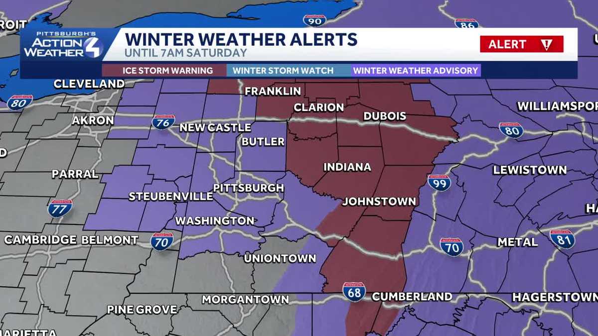
An Ice Storm Warning and multiple Winter Weather Advisories will go in place across Western Pennsylvania Friday.The National Weather Service issued the warnings and advisories ahead of Friday morning’s winter storm, which is expected to bring treacherous travel conditions.Severe weather alerts: See alerts for your county and sign up to get free alertsInteractive radar: Track storms moving through your areaLearn how to enable automatic weather alerts on the WTAE appIce Storm WarningAn Ice Storm Warning will go into effect at 10 a.m. Friday and remain in effect until 7 a.m. on Saturday for portions of northwest, southwest and western Pennsylvania. Impacted Counties: Venango, Forest, Clarion, Jefferson, Armstrong County, as well as higher elevations of Westmoreland and Indiana County. Impacted cities include Indiana, Oil City, Punxsutawney, Kittanning, Ford City, Donegal, Franklin, Tionesta, Brookville, Ligonier, Armagh, and Clarion.Ice Storm ImpactsThe National Weather Service warns travel could be nearly impossible and could bring hazardous conditions for post-holiday travel. Roads, bridges and overpasses will likely become hazardous and slick. Power outages and tree damage from ice are likely in these areas.PennDOT and the Pennsylvania Turnpike have released a number of vehicle restrictions. Click here to see if you’re impacted. Winter Weather AdvisoryThere are multiple Winter Weather Advisories for Friday’s storm.The following counties are under a Winter Weather Advisory from 8 a.m. to 3 p.m. on Friday:Carroll, Columbiana, Harrison, Jefferson (Ohio), Beaver, Allegheny, Washington, Hancock and Brooke. Impacted cities: Ambridge, Follansbee, Salem, Aliquippa, Beaver Falls, Wellsburg, Cadiz, Washington, East Liverpool, Canonsburg, Malvern, Columbiana, Monaca, Pittsburgh Metro Area, Weirton, Carrollton, and SteubenvilleThe following counties are under a Winter Weather Advisory from 8 a.m. Friday until 1 a.m. on Saturday:Mercer, Lawrence, Butler, Westmoreland, Eastern Preston, Eastern Tucker County. Impacted cities: Ellwood City, Sharon, Grove City, Monessen, Latrobe, Murrysville, Butler, Lower Burrell, Rowlesburg, Hazelton, Greensburg, Thomas, New Kensington, New Castle, Canaan Valley, Davis, Terra Alta, and HermitageHigher elevations of Fayette County, including cities of Champion and Ohiopyle will be under a Winter Weather Advisory from 8 a.m. on Friday to 1 a.m. on Saturday. Freezing rain is expected, bringing accumulations across Western Pennsylvania from glazing roadways to two tenths of an inch. You are advised to slow down and use caution while driving.
PITTSBURGH —
An Ice Storm Warning and multiple Winter Weather Advisories will go in place across Western Pennsylvania Friday.
The National Weather Service issued the warnings and advisories ahead of Friday morning’s winter storm, which is expected to bring treacherous travel conditions.
Ice Storm Warning
An Ice Storm Warning will go into effect at 10 a.m. Friday and remain in effect until 7 a.m. on Saturday for portions of northwest, southwest and western Pennsylvania.
Impacted Counties: Venango, Forest, Clarion, Jefferson, Armstrong County, as well as higher elevations of Westmoreland and Indiana County.
Impacted cities include Indiana, Oil City, Punxsutawney, Kittanning, Ford City, Donegal, Franklin, Tionesta, Brookville, Ligonier, Armagh, and Clarion.
This content is imported from Twitter.
You may be able to find the same content in another format, or you may be able to find more information, at their web site.
A storm system will bring freezing rain and ice accumulations to portions of the area Friday and Friday night. An Ice Storm Warning and Winter Weather Advisory are in effect for areas that are expected to see impacts. Remember, even a glaze of ice can make travel dangerous! pic.twitter.com/isuPHf0iKw
— NWS Pittsburgh (@NWSPittsburgh) December 25, 2025
Ice Storm Impacts
The National Weather Service warns travel could be nearly impossible and could bring hazardous conditions for post-holiday travel. Roads, bridges and overpasses will likely become hazardous and slick. Power outages and tree damage from ice are likely in these areas.
PennDOT and the Pennsylvania Turnpike have released a number of vehicle restrictions. Click here to see if you’re impacted.
Winter Weather Advisory
There are multiple Winter Weather Advisories for Friday’s storm.
The following counties are under a Winter Weather Advisory from 8 a.m. to 3 p.m. on Friday:
Carroll, Columbiana, Harrison, Jefferson (Ohio), Beaver, Allegheny, Washington, Hancock and Brooke.
Impacted cities: Ambridge, Follansbee, Salem, Aliquippa, Beaver Falls, Wellsburg, Cadiz, Washington, East Liverpool, Canonsburg, Malvern, Columbiana, Monaca, Pittsburgh Metro Area, Weirton, Carrollton, and Steubenville
The following counties are under a Winter Weather Advisory from 8 a.m. Friday until 1 a.m. on Saturday:
Mercer, Lawrence, Butler, Westmoreland, Eastern Preston, Eastern Tucker County.
Impacted cities: Ellwood City, Sharon, Grove City, Monessen, Latrobe, Murrysville, Butler, Lower Burrell, Rowlesburg, Hazelton, Greensburg, Thomas, New Kensington, New Castle, Canaan Valley, Davis, Terra Alta, and Hermitage
Higher elevations of Fayette County, including cities of Champion and Ohiopyle will be under a Winter Weather Advisory from 8 a.m. on Friday to 1 a.m. on Saturday.
Freezing rain is expected, bringing accumulations across Western Pennsylvania from glazing roadways to two tenths of an inch.
You are advised to slow down and use caution while driving.