
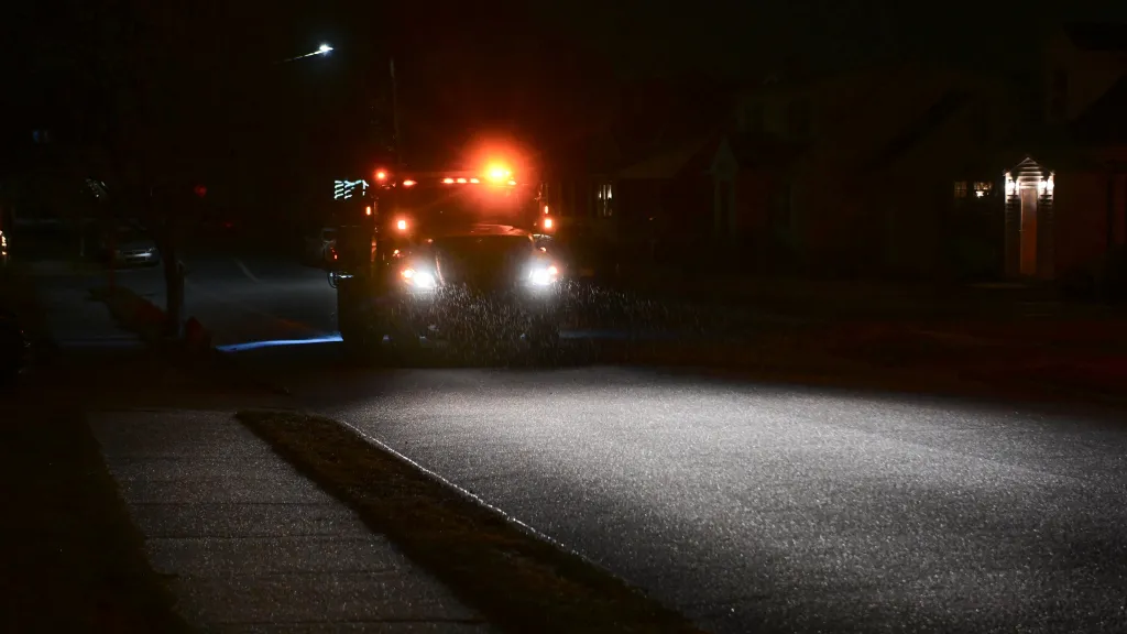
As wintry precipitation continues to fall across the Lehigh Valley on Friday evening, conditions on roads and sidewalks are “quite messy,” just as forecasters expected.
The latest winter storm to impact the region is bringing more sleet than snow, tamping down snowfall totals from earlier forecasts. The Lehigh Valley, as well as neighboring Bucks, Berks and Carbon counties, remain under a winter weather advisory until 10 a.m. Saturday.
Snowfall amounts
Most of the lower Lehigh Valley should see between 1 and 3 inches from the storm, according to the National Weather Service. However, northern portions of the Valley could see between 2 and 4 inches. Around 6 p.m. Friday evening, the weather service said another inch of snow was expected before the storm wrapped up.
However, up to nearly two-tenths of an inch of ice was now expected, significantly more than initial estimates.
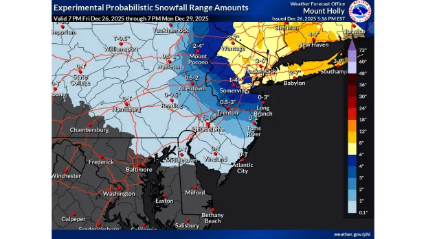 The latest snowfall projections from the National Weather Service’s Mount Holly, N.J., forecast office.
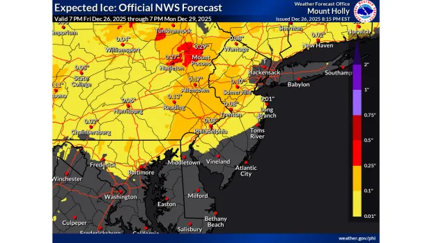 Projected ice accumulations from the National Weather Service’s Mount Holly, N.J., forecast office.
While the storm had initially been expected to bring higher snowfall totals, warm air is affecting the storm and causing sleet and freezing rain instead. Still, the weather service said the combination of snow, sleet, and even some freezing rain will be enough to make things “quite messy.”
Higher snow totals are expected in Monroe County and in New Jersey. Monroe County is under a winter storm warning through 10 a.m. Saturday, with snowfall amounts between 4 and 7 inches, according to the weather service.
“What all this means is that in areas north of I-78, we`ll likely see mostly snow throughout the event, from roughly Philly to I-78, we`ll see a widespread mix of snow and sleet generallyfavoring sleet,” according to the weather service’s forecast discussion. “or areas south and east of Philly it will be mostly a rain event.”
Snow and sleet are expected to continue, with some freezing rain possibly mixing in, through early Saturday morning, forecasters said.
Travel conditions and cancelations
Despite the lower snowfall projections in the Lehigh Valley, the weather service is warning the snow and ice that does fall will be enough to lead to hazardous travel conditions during the storm.
“The overarching theme still remains that the key threat will be widespread travel disruptions during the evening hours and heading into the overnight hours,” according to the forecast discussion.
By early Friday evening, road conditions were deteriorating across the region, with several crashes reported. One crash was reported with people trapped inside a vehicle on Route 22 westbound near the Route 309 interchange in South Whitehall Township just after 6 p.m., according to emergency radio dispatches. Another vehicle was reported to have gone off the road on Route 22 westbound through “Cemetery Curve” in Easton.
Earlier, a two-vehicle crash was reported on Nazareth Pike (Route 191) at the Route 22 interchange in Bethlehem Township, according to the Northampton County Emergency Alerts Facebook page.
Ahead of the storm, PennDOT issued Tier 3 vehicle restrictions on the following roads:
Interstate 78
Route 22 between I-78 and Route 33
Route 33, entire length
I-81, north of I-83.
Pennsylvania Turnpike (I-76, I-276 and I-476)
Under Tier 3 restrictions, all commercial vehicles are prohibited except loaded single trailers with chains or approved traction devices. School buses, commercial buses, motor coaches, motorcycles, RVs and vehicles towing trailers are also prohibited.
PennDOT said additional restrictions, including reduced speed limits, are possible during the storm.
LANTA, the Lehigh Valley’s transit agency, said it would stop picking up passengers on its bus routes as of 8 p.m., though it would continue dropping off passengers until reaching the next major transit center, or the end of the route. LANTA bus and van services will have a delayed start at 5 a.m. Saturday.
The weather also lead to events being canceled around the region, including the Lehigh Valley Zoo’s Winter Lights Spectacular. It’s the fourth weather-related cancelation of the season for the holiday lights display, which will reopen Saturday. Anyone with tickets for Friday will receive instructions on rescheduling.
Look ahead
After the wintry precipitation ends Saturday morning, things will clear out before a frontal system brings rain to the Lehigh Valley on Sunday into Monday. Behind the front, high pressure and colder temperatures will move in. High temperatures on Tuesday and Wednesday will be in the low 30s, well below normal for this time of year, according to forecasters.
Here is the extended forecast from the National Weather Service:
Saturday: Cloudy, then gradually becoming mostly sunny, with a high near 30. Northeast wind around 5 mph becoming calm in the afternoon.
Saturday Night: Mostly cloudy, with a low around 20. Calm wind.
Sunday: A chance of rain after 1 p.m. Cloudy, with a high near 39. Calm wind becoming southwest around 5 mph in the afternoon. Chance of precipitation is 50%. New precipitation amounts of less than a tenth of an inch possible.
Sunday Night: Rain. Low around 33. Chance of precipitation is 80%. New precipitation amounts between a tenth and quarter of an inch possible.
Monday: Showers, mainly before 1pm. High near 51. Chance of precipitation is 80%.
Monday Night: Mostly cloudy, with a low around 25. Breezy.
Tuesday: Mostly cloudy, with a high near 32. Breezy.
Tuesday Night: Mostly cloudy, with a low around 24.
Wednesday: Cloudy, with a high near 34.
Wednesday Night: Cloudy, with a low around 21.
New Year’s Day: Partly sunny, with a high near 30.