
Early AM rain Monday, then strong winds Monday afternoon through Tuesday across south-central Pennsylvania
More showers with a cold front will arrive Monday, followed by dropping temperatures and increasing winds with gusts up to 50 mph! Strong winds will linger into Tuesday.
AWESOME CONNECTION. LOOKING AT SOME RAIN AND WIND FOR YOUR MONDAY, WE’RE GOING TO START THE DAY OFF WITH SOME EARLY MORNING SHOWERS. WE’RE ALREADY STARTING TO SEE ON STORM TEAM LIVE AT OUR NETWORK. JUST SOME OF THE OUTER PERIPHERY OF SOME OF THOSE SHOWERS BEGINNING TO MOVE INTO THE COMMONWEALTH. BUT THE IMPACT ICON HERE, I WANTED TO SHOW YOU WE HAVE AN IMPACT DAY IN FOR MONDAY. AND THE REASON WHY IS WE’RE GOING TO HAVE INCREASING WINDS COMING IN FROM THE WEST SOUTHWEST. AND THAT’S WHERE THE WEST NORTHWEST AND THAT’S WHAT WE’RE GOING TO BE SEEING. GUSTS UP TO ABOUT 50MPH, FOLKS. AND WE’RE GOING TO HAVE FALLING AFTERNOON TEMPERATURES AND LOOKING AT VERY WINDY CONDITIONS FOR TUESDAY AS WELL. LOOK AT THIS. GUSTS OF 50MPH COULD SEE FEELS LIKE TEMPERATURES GETTING DOWN INTO THE TEENS AND STILL BREEZY AND CHILLY AS WE GET INTO OUR WEDNESDAY. WITH TEMPERATURES REMAINING INTO THE LOWER 30S. SO I PUT A FAIRLY WIDE TEMPERATURE RANGE IN FOR OVERNIGHT TONIGHT. COULD BE SEEING SOME PATCHY FOG ALREADY SEEING SOME SOME FOG RIGHT NOW DEVELOPING ACROSS THE AREA. BUT THE MAIN STORY HERE ARE THESE TEMPERATURES. WE’RE GOING UP IN TERMS OF TEMPERATURES OVERNIGHT TONIGHT FOLKS. THAT’S WHY I PUT THE ARROW THERE RIGHT AROUND 46 DEGREES WILL BE THE TEMPERATURES WHEN WE GET TO RIGHT AROUND 6 OR 7:00. AND YOU CAN SEE A WIDE TEMPERATURE RANGE INTO THE 50S FOR TOMORROW MORNING FOR SURE. WE’LL SEE SOME SHOWERS EARLY, BUT THEN MILD TEMPERATURES INTO THE 50S WILL BE ON TAP. YOU CAN SEE TURNING WINDY OUT OF THE WEST NORTHWEST BETWEEN 10 AND 20MPH, BUT THAT IMPACT ICON, A COLD FRONT IS GOING TO BE MOVING THROUGH. AND ONCE THAT MOVES ACROSS THE SUSQUEHANNA VALLEY, I’M GOING TO TELL YOU WHAT THESE GUSTS ARE GOING TO BE GETTING UP TO 50MPH. WE’LL ALSO SEE FALLING AFTERNOON AND EVENING TEMPERATURES. LOOK AT THIS TEMPERATURE RANGE RIGHT BETWEEN 48 DEGREES DROPPING DOWN TO 34 DEGREES REMAINING WINDY. SO IF YOU’RE LEAVING FOR WORK IN THE MORNING, YOU’RE GOING TO WANT TO MAKE SURE YOU’RE PACKING YOUR COAT. STILL, EVEN THOUGH WE HAVE TEMPERATURES INTO THE 50S AND IT FEELS MILD OUT THERE, YOU’RE GOING TO WANT TO MAKE SURE YOU PACK YOUR EXTRA COAT. IT’S GOING TO BE INTO THE 30S BY THE TIME YOU LEAVE WORK FOR TOMORROW. ALMANAC FOR THE DAY TODAY HIT A HIGH OF 33 DEGREES. 40 IS WHAT WE EXPECT FOR THIS TIME OF YEAR. SO A LITTLE BIT BELOW AVERAGE FOR THIS FOR THIS TIME OF THE YEAR IN DECEMBER IN TERMS OF OVERNIGHT LOWS, OR I SHOULD SAY YESTERDAY. WE’RE PAST MIDNIGHT NOW. EARLIER YESTERDAY MORNING WE WERE RIGHT AROUND 29 DEGREES. BUT 25 IS WHAT WE EXPECT FOR THIS TIME OF YEAR. BUT HERE’S CURRENT TEMPERATURES ACROSS THE AREA INTO THE 30S AT THIS TIME. 39 IN YORK, 43 DEGREES IN GETTYSBURG. ALREADY STARTING TO SEE SOME OF THOSE 40S MOVE IN. LET’S PLAY A GAME REAL QUICK. FIND THE COLD FRONT AND THE WARM FRONT. HOW CAN YOU TELL? OH, LOOK AT THIS. LOOK AT THIS SHARP BOUNDARY CUTTING THROUGH THE DEEP SOUTH, GETTING INTO THE TENNESSEE VALLEY AND THE OHIO RIVER VALLEY. LOOK AT THIS. 50 DEGREES IN DAYTON YOU CAN SEE 58 IN NASHVILLE, 62 IN ATLANTA. AT THIS TIME, YOU CAN SEE DOWN INTO THE TEENS SINGLE DIGITS FOR DES MOINES, LINCOLN AND NEBRASKA, RAPID CITY AND KANSAS CITY AT 16 DEGREES. NOW, WE WON’T BE GETTING DOWN TO DOWN TO THE TEENS IN TERMS OF HIGH TEMPERATURES, BUT WE’RE CERTAINLY GOING TO FEEL THE EFFECTS OF THIS COLD FRONT THAT’S GOING TO MOVE THROUGH. AND IT’S THIS WARM FRONT THAT’S ALLOWING FOR THOSE VERY MILD TEMPERATURES THAT WE’RE GOING TO BE FEELING AS WE GET INTO RIGHT AROUND NINE, 10:00 IN THE MORNING, YOU SEE SOME OF THESE SHOWER ICONS. BY THE TIME YOU GET TO FIVE, SEVEN, 9:00 IN THE MORNING. BUT THEN SOME OF THESE WINDS ARE GOING TO BE MOVING IN AND OUT OF THE SOUTH RIGHT NOW, BETWEEN 5 AND 10MPH. IT WILL BEGIN TO INCREASE BY THE TIME WE MAKE IT TO THE MONDAY MORNING COMMUTE BETWEEN 10 AND 15MPH FOR THE AFTERNOON. SUSTAINED WINDS BETWEEN 15 TO 25MPH. SO IF YOU HAPPEN TO HAVE ANYTHING THAT’S SITTING OUTSIDE, FOLKS THAT MAY GET BLOWN AWAY, YOU’RE GOING TO WANT TO MAKE SURE YOU’RE PREPARED AND YOU’RE PROBABLY FIGHTING THE PILLOW RIGHT NOW. I KNOW YOU’RE FIGHTING THE PILLOW, BUT IF YOU HAVE SOMETHING SITTING OUTSIDE THAT’S GOING TO BLOW AWAY, I SUGGEST YOU BRING IT INSIDE REAL QUICK AND THEN HIT THE BED FOR THE NIGHT. 47MPH. THAT’S GOING TO BE THE GUSTS FOR OR BY TOMORROW AFTERNOON. SO IT COULD HIT THAT 50 MILE PER HOUR RANGE FOR FOR THE AFTERNOON AND WIND CHILLS GETTING DOWN TO THE LOW 20S BY THE TIME WE GET TO TOMORROW EVENING, DOWN TO THE LOWER 20S. SO WE HAVE A WIND ADVISORY GOING IN EFFECT 7 A.M. MONDAY UNTIL 12 NOON TUESDAY. AND THAT’S WHY WE HAVE AN IMPACT DAY SET FOR BOTH MONDAY AND TUESDAY. FOR THOSE GUSTS, GETTING UP TO THE 50 MILE PER HOUR RANGE. SO STORM TEAM, LIVE RADAR NETWORK STARTING TO SEE SOME OF THOSE SHOWERS BEGINNING TO MOVE IN AND CLOSE IN ON THE ON THE WESTERN PORTIONS OF THE COMMONWEALTH, WARM AIR WILL START TO TAKE OVER THE SUSQUEHANNA VALLEY. SEEING SOME OF THOSE FEW SHOWERS FOR THE EARLY MORNING HOURS BETWEEN 6 AND 10:00. BUT THEN HERE COMES THIS COLD FRONT THAT’S GOING TO START TO BLOW THROUGH, AND THE WINDY AND COLDER CONDITIONS WILL BE PERSISTING THROUGHOUT THE ENTIRE EVENING. AND ALSO GETTING INTO OUR TUESDAY AS WELL. YOU CAN SEE REFLECTED IN OUR TEN DAY FORECAST. NEW YEAR’S EVE STILL MOSTLY CLOUDY AND CHILLY INTO THE LOW 30S. 32 DEGREES FOR NEW YEAR’S DAY. CAN YOU BELIEVE IT’S ALREADY 2026 COMING UP? CHANCE OF SOME LIGHT SNOW FOR YOUR THURSDAY. BRISK AND COLD AS WE GET INTO
Early AM rain Monday, then strong winds Monday afternoon through Tuesday across south-central Pennsylvania
More showers with a cold front will arrive Monday, followed by dropping temperatures and increasing winds with gusts up to 50 mph! Strong winds will linger into Tuesday.

Updated: 12:37 AM EST Dec 29, 2025
Tonight, skies remain cloudy and the wind increases out of the south, between 10-15 mph. Temperatures hold steady in the mid 30s, but after midnight they rise into the 40s.MONDAY AND TUESDAY ARE IMPACT DAYSA Wind Advisory has been issued for the entire Susquehanna Valley from 7 AM Monday through 12PM Tuesday.As a strong cold front moves through the Valley Monday, we’ll get one more brief period of a few showers early in the morning. Highs will hit near 50 degrees early Monday. Then, in the wake of the cold front, temperatures will plummet to the 30s by mid-afternoon, along with increasing westerly winds between 15 to 25 mph. Gusts may get up to 55 mph on Monday! It’s going to be a blustery rest of our Monday, so be prepared! IMPACTS: Scattered tree branches, downed trees, some power outages and any items not secure around your home may be blown away. If you drive a high profile vehicle, keep a firm grip with both hands on the steering wheel!On Tuesday, the winds remain strong, with gusts still near 40 mph. Highs only around 30 degrees will feel like the teens, to near 20 degrees, all day.The last day of 2025 is dry but chilly in the low 30s. If you are ringing in the new year outside, temperatures at midnight will be around 28 degrees so bundle up!Another front will take aim at the region on New Year’s Day, bringing a few light snow showers. Temperatures will be cold in the low 30s. Winds are breezy so wind chills will range from the teens to the 20s.The rest of the week into the weekend continues colder than average in the low to mid 30s. A quick moving system may bring a few rain/snow showers early Sunday.Have a great rest of your night!~ Ryan
Tonight, skies remain cloudy and the wind increases out of the south, between 10-15 mph. Temperatures hold steady in the mid 30s, but after midnight they rise into the 40s.
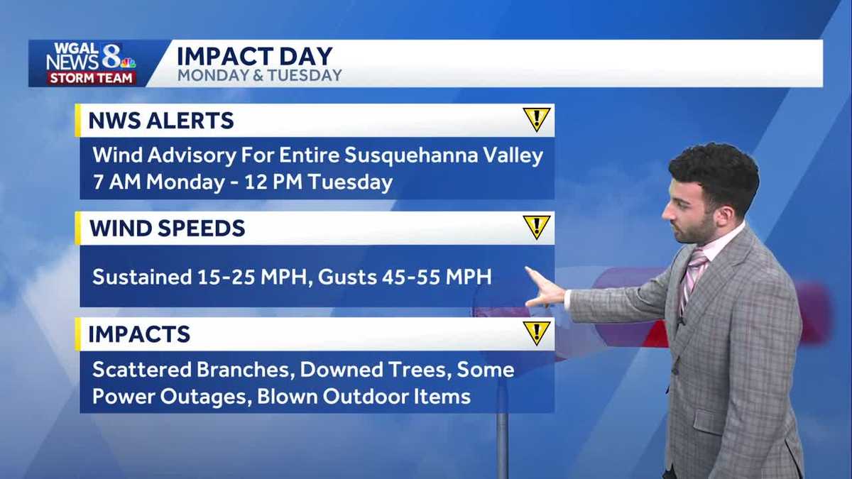
MONDAY AND TUESDAY ARE IMPACT DAYS
A Wind Advisory has been issued for the entire Susquehanna Valley from 7 AM Monday through 12PM Tuesday.
As a strong cold front moves through the Valley Monday, we’ll get one more brief period of a few showers early in the morning. Highs will hit near 50 degrees early Monday. Then, in the wake of the cold front, temperatures will plummet to the 30s by mid-afternoon, along with increasing westerly winds between 15 to 25 mph. Gusts may get up to 55 mph on Monday! It’s going to be a blustery rest of our Monday, so be prepared! IMPACTS: Scattered tree branches, downed trees, some power outages and any items not secure around your home may be blown away. If you drive a high profile vehicle, keep a firm grip with both hands on the steering wheel!
On Tuesday, the winds remain strong, with gusts still near 40 mph. Highs only around 30 degrees will feel like the teens, to near 20 degrees, all day.
The last day of 2025 is dry but chilly in the low 30s. If you are ringing in the new year outside, temperatures at midnight will be around 28 degrees so bundle up!
Another front will take aim at the region on New Year’s Day, bringing a few light snow showers. Temperatures will be cold in the low 30s. Winds are breezy so wind chills will range from the teens to the 20s.
The rest of the week into the weekend continues colder than average in the low to mid 30s. A quick moving system may bring a few rain/snow showers early Sunday.
Have a great rest of your night!
~ Ryan