
IMPACT DAY:A Wind Advisory is in effect until noon for all counties in the Susquehanna Valley. Expect sustained NW winds 15-25 mph, with gusts 45-55 mph. Intense gusts will diminish this afternoon, but windy conditions will persist through sunset. We’re looking at mostly cloudy skies to start the day, with a few snow showers west of the Susquehanna River and flurries east. Morning temperatures are in the upper 20s, and temperatures will only warm a few degrees to the low 30s this afternoon under partly sunny skies. Expect wind chills in the teens all day. Tonight, winds will diminish and clouds will increase. Lows will fall to the low 20s. New Year’s Eve will feature mainly cloudy skies and chilly temperatures near freezing. It will still be breezy, but not as windy as the past few days. For revelers across the region, expect midnight temperatures in the upper 20s with a light breeze and scattered snow showers, as a cold front passes between midnight and 2 a.m. Thursday. New Year’s Day will feature a brisk breeze and highs in the upper 20s under partly sunny skies. It will be the coldest day of the week!Temperatures rebound to the low 30s Friday. We’ll see a mix of clouds and sunshine. The first weekend of 2026 looks partly sunny and chilly. Average highs are near 40, but temperatures will hover in the low-to-mid 30s both days. A few snow showers are possible early Monday, otherwise expect below average temperatures to continue for the first week of the new year.
IMPACT DAY:
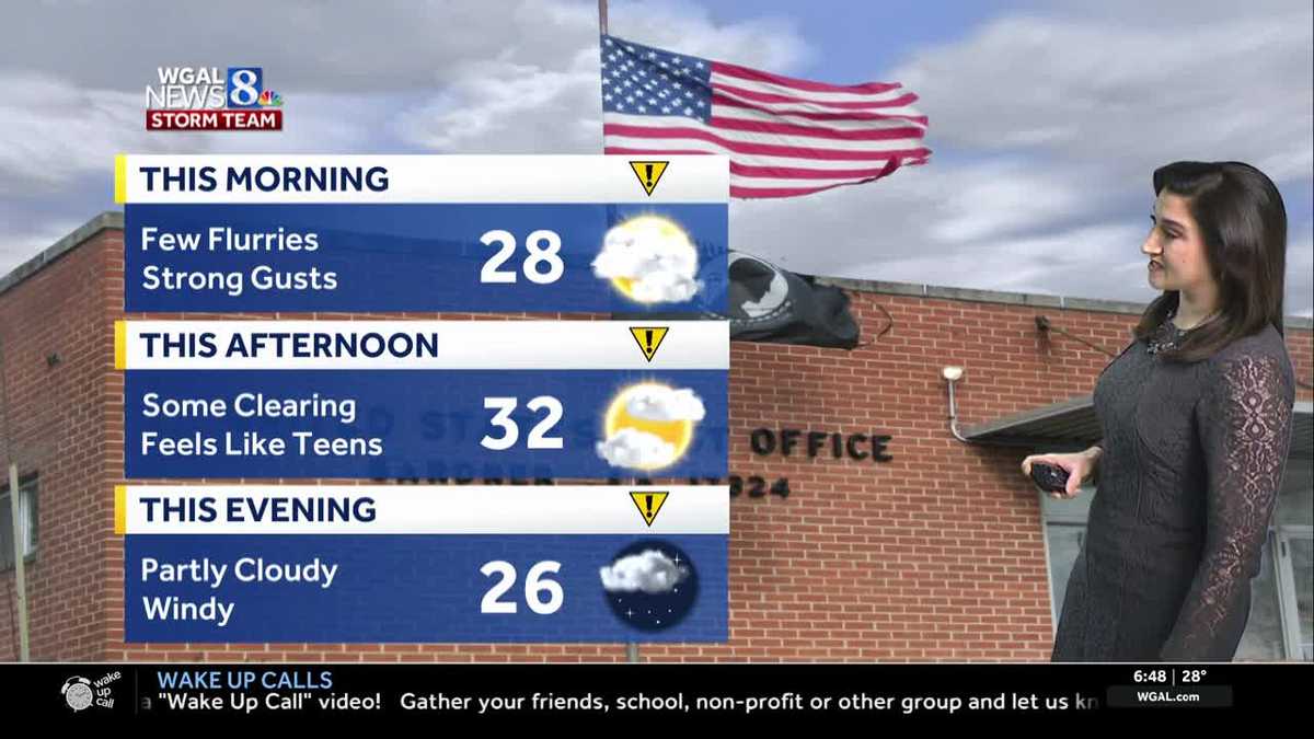
A Wind Advisory is in effect until noon for all counties in the Susquehanna Valley. Expect sustained NW winds 15-25 mph, with gusts 45-55 mph. Intense gusts will diminish this afternoon, but windy conditions will persist through sunset.
We’re looking at mostly cloudy skies to start the day, with a few snow showers west of the Susquehanna River and flurries east. Morning temperatures are in the upper 20s, and temperatures will only warm a few degrees to the low 30s this afternoon under partly sunny skies. Expect wind chills in the teens all day.
Tonight, winds will diminish and clouds will increase. Lows will fall to the low 20s.
New Year’s Eve will feature mainly cloudy skies and chilly temperatures near freezing. It will still be breezy, but not as windy as the past few days.
For revelers across the region, expect midnight temperatures in the upper 20s with a light breeze and scattered snow showers, as a cold front passes between midnight and 2 a.m. Thursday.
New Year’s Day will feature a brisk breeze and highs in the upper 20s under partly sunny skies. It will be the coldest day of the week!
Temperatures rebound to the low 30s Friday. We’ll see a mix of clouds and sunshine.
The first weekend of 2026 looks partly sunny and chilly. Average highs are near 40, but temperatures will hover in the low-to-mid 30s both days.
A few snow showers are possible early Monday, otherwise expect below average temperatures to continue for the first week of the new year.