
Cold on Sunday… Warming Next Week!
The January thaw kicks in next week with a big warm up and rain chances.
ACTION NEWS FOUR. SO IT IS DEFINITELY GOING TO BE A CHILLY ONE DOWN AT ACRISURE STADIUM. YOU WILL NEED TO BUNDLE UP, AND WHEN YOU THINK YOU’RE BUNDLED UP ENOUGH, YOU SHOULD PROBABLY BUNDLE UP SOME MORE, RIGHT? PROBABLY TWO MORE LAYERS ON TOP OF THAT, BECAUSE WE’RE STANDING OUT IN THE COLD FOR SO LONG. BETWEEN TAILGATING, OBVIOUSLY THE GAME AS WELL. SO THOSE COLD TEMPERATURES, A FO FOR THOSE THAT WILL BE ON THE FIELD AND ALSO IN THE STANDS AS WELL, HIGH TEMPERATURES THROUGH THE WEEKEND DON’T EVEN CRACK FREEZING. THAT WILL HAPPEN THOUGH. ON MONDAY. WE HAVE A LOT TO LOOK FORWARD TO AS WE HEAD INTO THE FIRST FULL WEEK OF JANUARY. THE THAW WILL BE UPON US AS TEMPERATURES WILL CLIMB NOT JUST THROUGH THE 30S AND 40S, BUT EVEN INTO THE 50S AND BEYOND. FAR CRY FROM THAT OUTSIDE. RIGHT NOW, THESE ARE THE ACTUAL AIR TEMPERATURES STILL HANGING ON TO THE SINGLE DIGITS IN WAYNESBURG. EVERYBODY ELSE LOW TO MID TEENS 16 RIGHT NOW FOR PITTSBURGH. IT’S 18 IN BEAVER. ALSO SEEING A MIX BETWEEN 16 AND 17 BETWEEN NEW CASTLE ALSO KITTANNING HERE AS WE GET THE MORNING STARTED CHECKING OUT YOUR FOUR DAY FORECAST. CLOUDS ARE OUT THERE. THEY’RE GOING TO BE PLENTIFUL THROUGHOUT THE DAY. ALSO, WE’LL SEE A FEW FLURRIES SNEAK IN LATER ON THIS AFTERNOON. ANY ACCUMULATIONS? NOTHING MORE THAN A COATING. MOST SPOTS WILL STAY UNDER HALF AN INCH UNTIL YOU CLIMB UP INTO THE LAUREL HIGHLANDS. THAT’S WHERE THOSE NUMBERS COULD JUMP A LITTLE CLOSER TO AN INCH. BY THIS TIME TOMORROW MORNING. OBVIOUSLY, WITH A LITTLE BIT OF SNOW COMING IN, THE COLD TEMPERATURES CAN’T RULE OUT A FEW SLIPPERY SPOTS, ESPECIALLY ON ELEVATED SURFACES. THINK BRIDGES AND OVERPASSES. IF YOU ARE GOING TO BE OUT TRAVELING LATER ON THIS EVENING, WE’LL START IN THE TEENS. CLIMB CLOSE TO 30 FOR YOUR STEELERS SUNDAY. IT’LL BE IN THE 20S, THOUGH, IN TIME FOR THE GAME AGAINST THE RAVENS, AS TEMPERATURES WILL BE AROUND 25. THE KICKOFF AT 820 CLOSER TO 20 DEGREES TOWARDS THE FOURTH QUARTER WITH JUST A LIGHT BREEZE AS WE GO THROUGH THE EVENING HOURS TOMORROW. THEN HERE COMES THAT THAW AS WE GET NEXT WEEK UNDERWAY. ANOTHER LIVE LOOK OF THE NORTH SHORE. YOU CAN ALSO SEE SOME OF THE ICE THAT IS FLOATING DOWN THE ALLEGHENY TOWARDS THE OHIO AS WELL. JUST ONE OF THE SIGNS THAT IT HAS BEEN PLENTY COLD HERE IN THE NEW YEAR. LOTS OF CLOUDS ACROSS THE AREA AS WE GO THROUGH THIS AFTERNOON. JUST LIKE YESTERDAY, GIVEN THE VERY COLD AIR. ALSO, THE CLOUDS OVERHEAD. WOULDN’T BE SURPRISED IF OCCASIONALLY YOU SEE A FEW OF THOSE TEENY TINY FLURRIES STARTING TO DEVELOP. MOST OF THE ACTION THOUGH, HOLDS OFF UNTIL LATER ON THIS EVENING. YOU CAN SEE A BATCH OF SOME LIGHT SNOW TRYING TO DEVELOP A CLOSER TO THE I-80 CORRIDOR. AS WE ROLL CLOSER TO 11:00 MIDNIGHT, A FEW MORE SNOW SHOWERS LINING UP THROUGH THE LAUREL HIGHLANDS AS THEY TYPICALLY DO. STARTING TO WORK UP IN ELEVATION. AND THAT’S WHERE WE COULD SEE THOSE VERY MINOR ACCUMULATIONS. TALKING ABOUT AN INCH OR LESS THROUGH DAYBREAK TOMORROW AND A FEW BREAKS FOR SUNSHINE ARE IN STORE AS WE WORK THROUGH THE AFTERNOON BEFORE SKIES SETTLE IN TO GO. PARTLY CLOUDY IN TIME FOR THE STEELERS GAME TOMORROW EVENING. AS WE FAST FORWARD TO MONDAY, ANOTHER FAST MOVING SYSTEM JUST CLIPPING US TO THE NORTH. MORE THAN LIKELY SNOW SHOWERS WILL BE CONFINED CLOSER TO THE I-80 CORRIDOR. OTHERWISE EVERYBODY ELSE STARTS TO TAP INTO THAT MILDER AIR AS TEMPERATURES WILL CLIMB INTO THE UPPER 30S. HOW ABOUT THE 40S? MID 40S AT THAT ON TUESDAY, WITH THE POSSIBILITY OF SOME LATE DAY RAIN CHANCES THAT COULD SPILL OVER INTO WEDNESDAY, TIMING HAS BEEN FLIP FLOPPING A BIT, SO WE’LL CONTINUE TO FINE TUNE THAT AS WE HEAD INTO NEXT WEEK. THE REST OF YOUR 4-DAY PLUS 4 MORE FORECAST WE’RE GETTING WARMER AND WETTER THURSDAY AND FRIDAY. THAT’S BEEN FAIRLY CONSISTENT OVER THE PAST COUPLE OF DAYS, SO WE’LL CONTINUE TO MONITOR ANY POSSIBILITY OF SOME HEAVY RAIN THERE. BUT CERTAINLY WITH THE WARM TEMPERATURES ON TAP, THE RAIN TO ALLOW THE SNOW IS GOING TO BE MELTING DOWN. SO I GUESS IF YOU’RE A WINTER LOVER FAN, ENJOY THESE TEMPERATURES WHILE THEY STAY BELOW FREEZING BECAUSE AT LEAST THE SNOW IS HERE FOR THE WEEKEND. SO MAYBE HEAD OUT TO SEVEN SPRINGS AND GET WHATEVER YOU NEED TO GET OUT OF YOUR SYSTEM DONE RIGHT, BECAUSE THE THAW IS GOING TO BE UPON US VERY QUICKLY. IT REA
Cold on Sunday… Warming Next Week!
The January thaw kicks in next week with a big warm up and rain chances.

Updated: 5:41 PM EST Jan 3, 2026
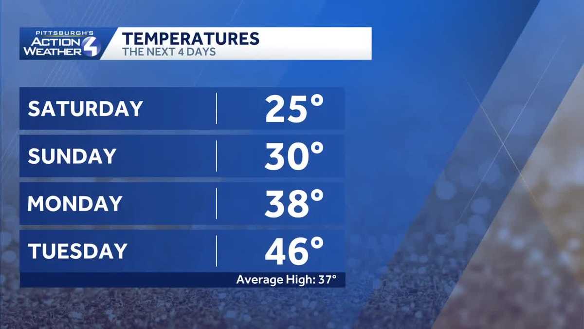
The cold air is here to stay through the first weekend of the year. Temperatures will finally climb above the freezing mark Monday afternoon. The January thaw kicks in next week with rain chances.Cold for the first weekend of the yearA weak disturbance will pass to our north, along I-80, and will produce isolated light snow showers overnight into early Sunday morning. A fresh coating is possible with up to an inch in the Laurels.Sunday will feature a few more sunny breaks with high temperatures inch toward the freezing mark. If you’re heading to the Steelers game on Sunday night, make sure you bundle up! The kickoff temperature will be in the 20s.The January thaw beginsTemperatures will finally break freezing as we start the first full week of 2026. Even our lows will be near the freezing mark. A few more light snow showers will cruise through on Monday, mainly near the I-80 corridor. The pattern change takes hold for the rest of the week.A big warm up and rain chancesAs temperatures climb into the 40s and 50s, we’ll introduce rain chances that will pepper the first full week of 2026. The first batch holds off until late Tuesday. The next best chance for rain arrives on Friday. OVERNIGHT: Flurries, mostly cloudy and cold. Low: 18°.SUNDAY: Breaks for some sunshine, still cold. High: 30°, low: 20°.MONDAY: Cloudy with isolated light snow showers north. High: 40°, low: 30°.TUESDAY: Milder with clouds and late-day rain showers. High: 48°.
PITTSBURGH —
The cold air is here to stay through the first weekend of the year. Temperatures will finally climb above the freezing mark Monday afternoon. The January thaw kicks in next week with rain chances.
Cold for the first weekend of the year

Hearst OwnedHearst
Temperatures only reach the mid 20s this afternoon under cloudy skies.
A weak disturbance will pass to our north, along I-80, and will produce isolated light snow showers overnight into early Sunday morning. A fresh coating is possible with up to an inch in the Laurels.

Hearst OwnedHearst
Scattered flurries and light snow showers after 6 PM could put down a fresh coating of snow.
Sunday will feature a few more sunny breaks with high temperatures inch toward the freezing mark. If you’re heading to the Steelers game on Sunday night, make sure you bundle up! The kickoff temperature will be in the 20s.
The January thaw begins
Temperatures will finally break freezing as we start the first full week of 2026. Even our lows will be near the freezing mark. A few more light snow showers will cruise through on Monday, mainly near the I-80 corridor. The pattern change takes hold for the rest of the week.

Hearst OwnedHearst
Monday’s flurry chance will closer to I-80 during the first half of the day. Milder air follows.
A big warm up and rain chances
As temperatures climb into the 40s and 50s, we’ll introduce rain chances that will pepper the first full week of 2026. The first batch holds off until late Tuesday. The next best chance for rain arrives on Friday.

Hearst OwnedHearst
Very warm with better chances by the end of next week for western Pennsylvania.
OVERNIGHT: Flurries, mostly cloudy and cold. Low: 18°.
SUNDAY: Breaks for some sunshine, still cold. High: 30°, low: 20°.
MONDAY: Cloudy with isolated light snow showers north. High: 40°, low: 30°.
TUESDAY: Milder with clouds and late-day rain showers. High: 48°.