
Warming trend midweek & rain chances return this week for south-central Pennsylvania
Temperatures remain below average another day but return to more seasonable norms Monday. With a pattern shift, 40s and 50s make a return this week. Next best chance for rain showers is late week.
AIRSPACE REOPENS. WHAT WE’RE TRACKING AS WE GET INTO THE WORKWEEK, WE’RE LOOKING AT A MILDER TREND OF TEMPERATURES ARRIVING. BUT BEFORE WE DEAL WITH THAT FOR YOUR MONDAY, LOOKING AT A FEW EARLY FLURRY CHANCES, ESPECIALLY TOWARDS OUR FAR NORTHERN COMMUNITIES, COULD BE LOOKING AT SOME PARTIAL SUNSHINE FOR THE MAJORITY OF THE DAY FOR YOUR MONDAY. THEN, AS WE GET INTO OUR TUESDAY, CHECK THIS OUT. TEMPERATURES TRENDING TO THE 40S AND EVENTUALLY THE 50S. BY THE TIME WE GET TO WEDNESDAY. SO WE’RE GOING TO HAVE THREE DIFFERENT DAYS OR THREE DAYS WORTH OF 50 DEGREE WEATHER. SO IF YOU’RE A WARM WEATHER LOVER OUT THERE, LOOK FORWARD TO THE NEXT FEW DAYS COMING UP. IT’S DEFINITELY GOING TO BE WARM AND MILDER THEN FOR LATE FOR LATER IN THE WEEK. LOOKING AT SOME BETTER RAIN CHANCES ON THE WAY FOR YOUR FRIDAY AND SATURDAY ESPECIALLY, WE DO SEE SOME RAIN CHANCES FOR YOUR LATE TUESDAY OR LATE TUESDAY NIGHT INTO WEDNESDAY MORNING, BUT THE BETTER. THOSE RAIN CHANCES REMAIN UNTIL THIS COMING WEEK, TOWARDS THE END OF THE WEEK, TOWARDS FRIDAY AND SATURDAY, SO MOSTLY CLOUDY CONDITIONS WITH A SEASONAL CHILL IN THE AIR DOWN TOWARDS THE 20S WILL HAVE LIGHTER WINDS OUT OF THE NORTH, LET’S SAY BETWEEN 5 AND 10MPH. THEN FOR TOMORROW MORNING, LOOKING AT MOSTLY CLOUDY CONDITIONS, YOU MAY SEE A FEW FLURRIES FLYING THROUGH THE AIR, FOLKS, BUT WE’LL REALLY JUST BE BE SEEING MOSTLY CLOUDY CONDITIONS FOR THE MOST PART. IF YOU SEE ANY FLURRIES, ESPECIALLY IF YOU’RE TOWARDS MIFFLIN OR JUNIATA COUNTIES, YOU’RE TUNING INTO THIS. YOU MIGHT SEE SOME FLURRIES FLYING AROUND, BUT FOR THE MAJORITY OF US REALLY LOOKING AT MOSTLY CLOUDY CONDITIONS, TEMPERATURES RIGHT INTO THE LOWER TO MID 20S. THEN FOR TOMORROW AFTERNOON, LOOK FOR SOME PARTIAL SUNSHINE. FEELING SEASONABLE FOR THIS TIME OF YEAR 38 DEGREES. THAT’S WHAT WE’RE EXPECTING. SO BETWEEN THAT 36 AND 40 DEGREE MARK FOR THE AFTERNOON ALMANAC FOR THE DAY TODAY MADE IT TO 33 DEGREES AT HARRISBURG INTERNATIONAL AIRPORT. BUT 39 IS WHAT WE EXPECT FOR THIS TIME OF THE YEAR. SO JUST WE’RE BELOW AVERAGE IN TERMS OF DAYTIME HIGHS. EARLIER THIS MORNING WAY, WAY EARLIER THIS MORNING HIT RIGHT AROUND 26 DEGREES FOR A LOW 24 IS WHAT WE EXPECT FOR THIS TIME OF YEAR. SO WE’RE RIGHT AROUND PAR FOR WHAT TO EXPECT. ONLY ABOUT A TRACE OF RAINFALL WAS RECORDED AT HARRISBURG INTERNATIONAL AIRPORT. SO WE HAVEN’T TALKED ABOUT THIS IN A WHILE. THE DROUGHT MONITOR AND ALSO SOME OF THE RAINFALL STATISTICS. WE’RE JUST OVER -1.6IN OF RAIN ACROSS THE SUSQUEHANNA VALLEY. AND THAT YOU CAN SEE THAT’S REFLECTED HERE IN THE DROUGHT MONITOR. THE MAJORITY OF THE AREA IS DEALING WITH A BIT OF A MODERATE DROUGHT SITUATION. YOU CAN SEE WITH SOME OF THE TAN THAT YOU’RE SEEING ACROSS MOST OF OUR AREA, BUT YOU CAN SEE TOWARDS OUR EASTERN COUNTIES LOOKING AT MORE SO ABNORMALLY DRY CONDITIONS TOWARDS LANCASTER AND YORK COUNTIES. PORTIONS OF DAUPHIN COUNTY, ALSO LEBANON COUNTY. BUT RAIN CHANCES THEY WON’T BE GOING BACK UP OR SIGNIFICANTLY UP UNTIL RIGHT AROUND FRIDAY OR SATURDAY. BUT YOU CAN SEE THAT RAIN CHANCE TUESDAY NIGHT GETTING INTO VERY EARLY WEDNESDAY ONLY REALLY ABOUT A 10% CHANCE. BUT THE BETTER. THOSE CHANCES REMAIN FOR FRIDAY AND SATURDAY, TEMPERATURES INTO THE 20S FOR LANCASTER, YORK, GETTYSBURG, CHAMBERSBURG AT THIS TIME 28. IN LEWISTOWN INTO THE LOWER 30S FOR CARLISLE, HARRISBURG, LEBANON AND SELINSGROVE. BUT YOU CAN STILL SEE WE STILL HAVE THAT LIGHT WIND COMING OUT OF THE NORTHWEST. I SAY GENERALLY CLOSE TO TEN MILES PER HOUR, BUT GENERALLY BETWEEN 5 AND 10MPH. THAT PROBABLY MAKES IT FEEL A LITTLE BIT CHILLIER OUTSIDE THAN WHAT THE AIR TEMPERATURE ACTUALLY IS. STORM TEAM LIVE RADAR NETWORK SEEING MOSTLY CLOUDY CONDITIONS. YOU CAN SEE WITH SOME BRIEF HIGH PRESSURE BUILDING IN IT KIND OF CLEARS OUR SKIES, BUT REALLY DEALING WITH MOSTLY CLOUDY CONDITIONS FOR THE MOST PART. AND THEN AS WE GET INTO OUR MONDAY EVENING, GETTING INTO OUR TUESDAY, LOOK AT THIS. HERE COMES THE MILDER AIR SURGING INTO THE VALLEY FOR YOUR TUESDAY. THAT’S WHAT’S GOING TO BE GIVING US OUR WARMER TEMPERATURES. AND YOU CAN SEE SOME OF THOSE SHOWER CHANCES BEGINNING TO MOVE IN FOR LATE TUESDAY. SO YOU CAN SEE THAT’S REFLECTED ON TUESDAY’S FORECAST. 44 DEGREES GETTING INTO THE 50S FOR YOUR WEDNESDAY, THURSDAY AND FRIDAY. AND THERE’S THOSE CHANCES FOR SOME SHOWERS
Warming trend midweek & rain chances return this week for south-central Pennsylvania
Temperatures remain below average another day but return to more seasonable norms Monday. With a pattern shift, 40s and 50s make a return this week. Next best chance for rain showers is late week.

Updated: 11:01 PM EST Jan 4, 2026
Expect increasing clouds ahead of some upper level energy that will pass through overnight tonight into Monday morning. Temperatures will drop through the upper 20s with winds diminishing out of the northwest.The next shortwave brings clouds back tonight into early Monday. A few flurries in northwestern counties are possible the chance is very low. Lows are in the mid 20s. Sunshine increases during the afternoon and highs are more seasonable in the upper 30s.Another disturbance approaches the area on Tuesday bringing plenty of cloud cover for the day. There may be a few showers late towards evening. We’ll watch for some light mixing at higher elevations. Overall, there isn’t much moisture with the system. Highs are milder and above average in the low 40s.Early clouds give way to brighter skies during the afternoon Wednesday. After a mild start in the low to mid 30s, and warmer air surging into the area, temperatures easily climb to near 50 degrees.Thursday is dry and mild in the low 50s under partly sunny skies.Our best chances for showers are Friday and Saturday, as a couple of frontal boundaries cross the Susquehanna Valley. It is mild both days but colder moves inHave a great rest of your night!~ Ryan
Expect increasing clouds ahead of some upper level energy that will pass through overnight tonight into Monday morning. Temperatures will drop through the upper 20s with winds diminishing out of the northwest.
The next shortwave brings clouds back tonight into early Monday. A few flurries in northwestern counties are possible the chance is very low. Lows are in the mid 20s. Sunshine increases during the afternoon and highs are more seasonable in the upper 30s.
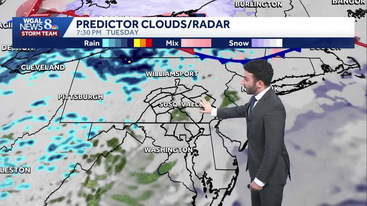
Another disturbance approaches the area on Tuesday bringing plenty of cloud cover for the day. There may be a few showers late towards evening. We’ll watch for some light mixing at higher elevations. Overall, there isn’t much moisture with the system. Highs are milder and above average in the low 40s.
Early clouds give way to brighter skies during the afternoon Wednesday. After a mild start in the low to mid 30s, and warmer air surging into the area, temperatures easily climb to near 50 degrees.
Thursday is dry and mild in the low 50s under partly sunny skies.
Our best chances for showers are Friday and Saturday, as a couple of frontal boundaries cross the Susquehanna Valley. It is mild both days but colder moves in
Have a great rest of your night!
~ Ryan