
Scattered showers moving out; more rain Saturday in south-central Pennsylvania
Temps are feeling like mid-March this evening, then fall to the 40s Saturday and Sunday. Rain will taper this evening, chances continue into Saturday. Sunday is looking drier & sunnier, while temperatures fall back to the 40s!
NOW, THE WGAL NEWS EIGHT STORM TEAM FORECAST, WITH METEOROLOGIST RYAN ARGENTI. BIT OF A GRAY AND DREARY DAY TODAY SO FAR. THAT’S ALL THANKS TO THE SYSTEM THAT’S PUSHING THROUGH AND ALLOWING FOR SOME SCATTERED SHOWER CHANCES ACROSS THE AREA. SO THAT’S SO IT’S REALLY BEEN A RAINY END TO THE WEEK. WE’RE GOING TO CONTINUE TO SEE PERIODS OF RAIN THROUGH THE REST OF THIS EVENING. AND ALSO GETTING INTO OUR SATURDAY REALLY THROUGH SATURDAY NIGHT. BUT THEN LOOKING AHEAD INTO THE SECOND HALF OF THE WEEKEND, WE’RE GETTING WINDY AND WE’RE GOING TO BE GETTING COOLER AS WELL. WE HAVE GUSTY WINDS ON SUNDAY AND MONDAY FEELING SEASONABLE THOUGH, BUT WE’RE GOING TO BE POTENTIALLY SEEING GUSTS OF UP TO 35MPH BY THE SECOND HALF OF THE WEEKEND. BUT WE ARE LOOKING AT AN UNSETTLED PATTERN LATER NEXT WEEK WITH A FEW CHANCES FOR SOME RAIN AND ALSO SOME POSSIBLE SNOW SHOWERS, WHICH ARE GOING TO BE WE’LL BE CHATTING ABOUT HERE IN THE TEN DAY FORECAST IN JUST A COUPLE OF MINUTES. SO FOR THE REST OF THIS EVENING, WE’RE SEEING SOME OF THESE SHOWERS MOVING OUT OF THE AREA. BUT WE’LL START TO SEE THOSE SHOWERS END STILL REMAINING MILD BETWEEN 46 AND 52 DEGREES IN TERMS OF TEMPERATURES THIS EVENING. THEN FOR TONIGHT, MOSTLY CLOUDY COOL STRAY SHOWER CHANCES POSSIBLE 36 TO 40 DEGREES. AND THEN AS WE GET INTO TOMORROW AFTERNOON, 40 TO 44 WITH RAIN DEVELOPING ONCE AGAIN, THIS IS GOING TO BE WITH ANOTHER SYSTEM THAT’S GOING TO PUSH THROUGH. WE’LL SEE OVERCAST CONDITIONS AND COOLER CONDITIONS WILL BE RIGHT DOWN TO THE LOWER 40S FOR TOMORROW AFTERNOON HIGHS. BUT THE PENNSYLVANIA FARM SHOW TODAY, FOOD COURT IT’S STILL OPEN. SO IF YOU STILL HAVE TO GET OUT TO GET OUT TO HARRISBURG AND YOU WANT TO GO TRY OUT SOME OF THE FOOD AND THE FOOD COURT, YOU STILL HAVE SOME TIME, ALTHOUGH DEFINITELY GOING TO BE A LITTLE BIT WET FOR FIVE AND 7:00. STILL REMAINING MILD, THOUGH BY THE TIME WE END OUR EVENING, BY THE TIME THE FOOD COURT CLOSES FOR THE EVENING. BUT LATEST PRECIPITATION TOTALS SO FAR THIS IS OF THE MORNING CLIMATOLOGICAL REPORT. SO FAR. WE’RE BELOW NORMAL ABOUT THREE QUARTERS OF AN INCH OF RAIN AT THIS TIME. NOW, SEASON TO DATE, THIS IS AS OF FROM DECEMBER 1ST TO NOW, ONLY HAD ABOUT 2.18IN OF RAIN. WE’RE BELOW NORMAL. WE’RE ABOUT TWO INCHES BELOW AVERAGE FOR WHERE WE NEED TO BE. AND YOU CAN SEE THAT’S REFLECTED IN OUR DROUGHT MONITOR HERE. THE MAJORITY OF THE SUSQUEHANNA VALLEY IS UNDER A MODERATE DROUGHT SITUATION. AND A LITTLE BIT OF A SEVERE DROUGHT BEGINNING TO CREEP IN TOWARDS OUR FAR SOUTHWESTERN COMMUNITIES, TOWARDS FRANKLIN COUNTY AND ADAMS COUNTY, AND A LITTLE IN TOWARDS OUR FAR SOUTHWESTERN PORTIONS OF YORK COUNTY. SEEING A BIT OF THAT SEVERE DROUGHT BEGINNING TO MOVE THROUGH. BUT BUT REGARDLESS, LOOKING AT VERY DRY CONDITIONS ACROSS THE AREA. SO SEEING ABNORMALLY DRY CONDITIONS FOR OUR EASTERN AREAS. BUT WE’RE WATCHING THESE SHOWERS MOVING OUT OF THE AREA AND IT’S VERY BENEFICIAL RAIN. SO WE DEFINITELY NEED THE RAIN. SO IF WE ZOOM OUT THOUGH, YOU CAN STILL SEE IT’S STILL LOOKING AT A BIT OF A SYSTEM THAT’S PUSHING THROUGH. BUT THAT’S ALL THANKS TO A COLD FRONT THAT’S GOING TO CONTINUE TO MAKE ITS WAY THROUGH THE VALLEY. BUT ONCE WE GET INTO TOMORROW, YOU CAN SEE THE OUTER FRINGES OF THIS NEXT SYSTEM COMING THROUGH TOMORROW MORNING. YOU SEE RIGHT AROUND 9:00, 930. THAT’S WHEN WE START TO SEE THE EDGE OF THE SYSTEM THAT’S GOING TO COME THROUGH, THAT’S GOING TO ALLOW FOR SOME WIDESPREAD SHOWERS ACROSS THE VALLEY, EVEN SOME MODERATE POCKETS OF SOME SHOWERS. AGAIN, VERY BENEFICIAL RAIN. AGAIN, WE’RE TWO INCHES BELOW AVERAGE FOR THE SEASON SO FAR. SO WE DEFINITELY NEED THE RAIN. THAT SYSTEM STARTS TO MOVE OUT NOW AS THIS COLD FRONT STARTS TO MOVE. WE MAY SEE SOME LINGERING SHOWERS IN THE WAKE OF THAT FRONT. AS YOU CAN SEE, PREDICTOR IS HIGHLIGHTING THAT FOR US. WE MAY SEE SOME MORE SHOWER CHANCES. AND THEN ONCE WE GET INTO OUR SUNDAY LOOKING DRY, MOSTLY SUNNY FOR THE MOST PART, BUT I CAN’T RULE OUT A CHANCE OF A FLURRY OR TWO OR A VERY LIGHT SNOW SHOWER. YOU CAN SEE SOME OF THAT NORTHWESTERLY FLOW COMING IN ON SUNDAY MAY ALLOW FOR A FLURRY OR TWO FOR OUR SUNDAY, BUT OVERALL LOOKING SUNNIER AND ALSO MUCH DRIER. BUT IN TERMS OF RAINFALL, LOOKING AT ABOUT A QUARTER INCH QUARTER OF AN INCH TO MAYBE THREE QUARTERS OF AN INCH OF RAIN, THREE QUARTERS OF AN INCH IN ISOLATED AREAS. BUT OVERALL, THAT’S WHAT WE’RE LOOKING AT FOR OUR PRECIPITATION RANGE. BUT THEN LOOKING AHEAD INTO NEXT WEEK. BLUSTERY START TO THE WORKWEEK 40 DEGREES. CALMER THOUGH FOR YOUR TUESDAY AND A FEW SHOWER. CHANCES ARE ON TAP FOR WEDNESDAY AND THURSDAY, AND WIT
Scattered showers moving out; more rain Saturday in south-central Pennsylvania
Temps are feeling like mid-March this evening, then fall to the 40s Saturday and Sunday. Rain will taper this evening, chances continue into Saturday. Sunday is looking drier & sunnier, while temperatures fall back to the 40s!

Updated: 4:30 PM EST Jan 9, 2026
Scattered showers will move out of southeastern counties early this evening. The mild stretch continues for one more day, as temperatures hover in the mid to upper 40s this evening. Southerly winds will subside to a 5-10 mph breeze. Tonight, a cold front will drift south of the state line and linger over Maryland. Expect cloudy skies and temperatures in the upper 30s. Winds will be lighter.If you need to get anything done outdoors, early Saturday morning is your best bet. Rain will return from south to north by lunchtime Saturday. A soaking rain is expected through the afternoon, wrapping up by evening. Two-day rain totals will range between 0.25″ to 0.75″ for most of the area. Higher totals near 1″ are possible southeast. Saturday’s highs will reach the low 40s, much cooler than the stretch of 50s we’ve seen over the past few days.Sunday will be the drier half of the weekend. Highs will reach the low 40s, but with a stiff 15-25 mph wind, it will feel like the 30s. Look for a mix of clouds and sunshine.More sunshine is in store Monday, as high pressure builds to our south. Temperatures will remain a few degrees above average, near 40. However, the wind will make it feel like the low 30s. Winds diminish Monday evening.After a dry and calmer Tuesday, a chance of rain showers returns Wednesday. A chance of rain/snow showers may linger into Thursday. Highs will fall to the mid-30s at the end of the week, more typical for mid-January.Looking into the upcoming holiday weekend, highs will stay in the 30s with a chance of snow showers Sunday.
Scattered showers will move out of southeastern counties early this evening. The mild stretch continues for one more day, as temperatures hover in the mid to upper 40s this evening. Southerly winds will subside to a 5-10 mph breeze.
Tonight, a cold front will drift south of the state line and linger over Maryland. Expect cloudy skies and temperatures in the upper 30s. Winds will be lighter.
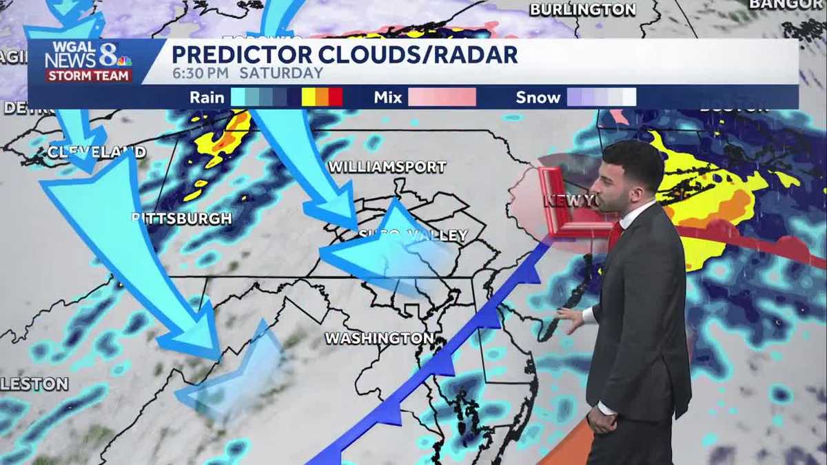
If you need to get anything done outdoors, early Saturday morning is your best bet. Rain will return from south to north by lunchtime Saturday. A soaking rain is expected through the afternoon, wrapping up by evening. Two-day rain totals will range between 0.25″ to 0.75″ for most of the area. Higher totals near 1″ are possible southeast. Saturday’s highs will reach the low 40s, much cooler than the stretch of 50s we’ve seen over the past few days.
Sunday will be the drier half of the weekend. Highs will reach the low 40s, but with a stiff 15-25 mph wind, it will feel like the 30s. Look for a mix of clouds and sunshine.
More sunshine is in store Monday, as high pressure builds to our south. Temperatures will remain a few degrees above average, near 40. However, the wind will make it feel like the low 30s. Winds diminish Monday evening.
After a dry and calmer Tuesday, a chance of rain showers returns Wednesday. A chance of rain/snow showers may linger into Thursday. Highs will fall to the mid-30s at the end of the week, more typical for mid-January.
Looking into the upcoming holiday weekend, highs will stay in the 30s with a chance of snow showers Sunday.