
This is a reality check after the thaw. Today’s Impact Day is for scattered light snow showers, especially this afternoon. Accumulations will be under an inch for most, but visibility could be an issue as wind gusts pick up. Chilly and dry for the Steelers wild card game Monday night.Temperatures will hold steady in the lower 30s today. Turning blustery with strong wind gusts of 25 to 35 mph this afternoon. Wind chills will be knocked back into the teens this afternoon.More scattered snow blow in this afternoon. There is the potential for isolated snow squalls with reduced visibility and quick light accumulations. Most of western Pennsylvania could pick up around half an inch. Locally higher amounts are possible along the I-80 corridor and in the Laurel Highlands. Winter Weather Advisory Issued:A Winter Weather Advisory has been issued for parts of Western Pennsylvania starting Sunday morning. The National Weather Service said the advisory will be in place for 8 a.m. Sunday to 1 a.m. Monday for the following: Higher Elevations of Fayette and Westmoreland counties. Cities include Ligonier, Donegal, Champion, and Ohiopyle. Snow is expected, with accumulations between two to four inches. Wind gusts are expected to reach 40 miles per hour. Chilly but dry for the Steelers Monday A textbook January day for our Steelers on Monday. It will stay breezy through the afternoon with temperatures in the mid to upper 30s under intervals of sunshine and clouds. Once the sun goes down, the wind will settle. The Steelers and Texans will kick off with a temperature closer to freezing.Rain to snow chance mid-weekTuesday will be slightly milder with temperatures pushing into the upper 40s. We are watching our next system on Wednesday. It will be mostly rain, however a brief period of mixing for areas north and east is possible. Colder air will wrap around on the backside. Lingering flurries and light snow, especially south of Pittsburgh, on Thursday with highs dropping back below freezing. TODAY – Impact Day: Scattered light snow and isolated snow squalls. Blustery with winds gusting 25-35 mph. High: 33°, wind chills in the teens late.TONIGHT: Breezy with partly to mostly cloudy skies. Low: 27°.MONDAY: Breezy through the afternoon with intervals of sun and clouds. High: 38°, low: 28°.TUESDAY: Milder with increasing clouds. High: 48°, low: 39°.
Pennsylvania —
This is a reality check after the thaw. Today’s Impact Day is for scattered light snow showers, especially this afternoon. Accumulations will be under an inch for most, but visibility could be an issue as wind gusts pick up. Chilly and dry for the Steelers wild card game Monday night.
Temperatures will hold steady in the lower 30s today. Turning blustery with strong wind gusts of 25 to 35 mph this afternoon. Wind chills will be knocked back into the teens this afternoon.

More scattered snow blow in this afternoon. There is the potential for isolated snow squalls with reduced visibility and quick light accumulations.
Most of western Pennsylvania could pick up around half an inch. Locally higher amounts are possible along the I-80 corridor and in the Laurel Highlands.
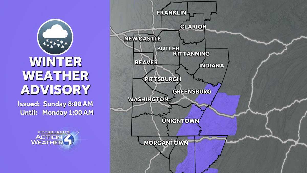
Winter Weather Advisory Issued:
A Winter Weather Advisory has been issued for parts of Western Pennsylvania starting Sunday morning.
The National Weather Service said the advisory will be in place for 8 a.m. Sunday to 1 a.m. Monday for the following: Higher Elevations of Fayette and Westmoreland counties.
Cities include Ligonier, Donegal, Champion, and Ohiopyle.
Snow is expected, with accumulations between two to four inches. Wind gusts are expected to reach 40 miles per hour.

Chilly but dry for the Steelers Monday
A textbook January day for our Steelers on Monday.
It will stay breezy through the afternoon with temperatures in the mid to upper 30s under intervals of sunshine and clouds. Once the sun goes down, the wind will settle. The Steelers and Texans will kick off with a temperature closer to freezing.

Rain to snow chance mid-week
Tuesday will be slightly milder with temperatures pushing into the upper 40s. We are watching our next system on Wednesday. It will be mostly rain, however a brief period of mixing for areas north and east is possible. Colder air will wrap around on the backside. Lingering flurries and light snow, especially south of Pittsburgh, on Thursday with highs dropping back below freezing.

TODAY – Impact Day: Scattered light snow and isolated snow squalls. Blustery with winds gusting 25-35 mph. High: 33°, wind chills in the teens late.
TONIGHT: Breezy with partly to mostly cloudy skies. Low: 27°.
MONDAY: Breezy through the afternoon with intervals of sun and clouds. High: 38°, low: 28°.
TUESDAY: Milder with increasing clouds. High: 48°, low: 39°.