
Another warm day across the Valley with partly sunny skies and highs in the mid 70s. The breeze picks up out of the south 10 to 20 mph, with gusts pushing 30 mph. Non-thunderstorm wind gusts of 30 to 40 mph are still possible this evening. As a slow-moving cold front approaches the area this evening, a line of gusty rain showers and storms are expected to impact the Valley. Main timing is between 7 PM and 2 AM.The Storm Prediction Center has highlighted the Susquehanna Valley in a Marginal Risk (a level 1 out of 5) for severe weather with isolated damaging wind gusts & heavy rain as the primary threats. A brief spin-up tornado is possible for eastern counties; however, the threat is very low.The News 8 Storm Team has declared an Impact period for tonight from 7 PM – 2 AM. Also, if you have outdoor holiday decorations, such as inflatables or other items that may be unfastened, you may want to consider bringing them inside temporarily for the night.Once the cold front pushes through, rain chances stick around through Monday morning as the upper-level system continues swinging across the Commonwealth. So, for your Monday morning commute, expect some lingering showers up until around noon to 1 PM Monday. Skies become sunnier by the afternoon. It will be cooler & breezy, thanks to west-northwest winds of 10 to 20 mph. Winds may gust to 30 mph again. Highs will fall back to more seasonable norms in the low 60s.Expect partly sunny skies Tuesday. Highs are back in the mid 60s. There may be a few showers in the evening, as the next front approaches. In the wake of the front, temperatures drop back to the 50s to around 60-degrees the rest of the week.Next weekend, another system brings rain chances back Saturday with slightly milder temperatures and dry conditions Sunday.Have a safe rest of your evening!~ Ryan
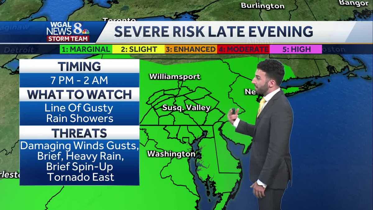
Another warm day across the Valley with partly sunny skies and highs in the mid 70s. The breeze picks up out of the south 10 to 20 mph, with gusts pushing 30 mph. Non-thunderstorm wind gusts of 30 to 40 mph are still possible this evening. As a slow-moving cold front approaches the area this evening, a line of gusty rain showers and storms are expected to impact the Valley. Main timing is between 7 PM and 2 AM.
The Storm Prediction Center has highlighted the Susquehanna Valley in a Marginal Risk (a level 1 out of 5) for severe weather with isolated damaging wind gusts & heavy rain as the primary threats. A brief spin-up tornado is possible for eastern counties; however, the threat is very low.
The News 8 Storm Team has declared an Impact period for tonight from 7 PM – 2 AM. Also, if you have outdoor holiday decorations, such as inflatables or other items that may be unfastened, you may want to consider bringing them inside temporarily for the night.
Once the cold front pushes through, rain chances stick around through Monday morning as the upper-level system continues swinging across the Commonwealth. So, for your Monday morning commute, expect some lingering showers up until around noon to 1 PM Monday. Skies become sunnier by the afternoon. It will be cooler & breezy, thanks to west-northwest winds of 10 to 20 mph. Winds may gust to 30 mph again. Highs will fall back to more seasonable norms in the low 60s.
Expect partly sunny skies Tuesday. Highs are back in the mid 60s. There may be a few showers in the evening, as the next front approaches. In the wake of the front, temperatures drop back to the 50s to around 60-degrees the rest of the week.
Next weekend, another system brings rain chances back Saturday with slightly milder temperatures and dry conditions Sunday.
Have a safe rest of your evening!
~ Ryan