
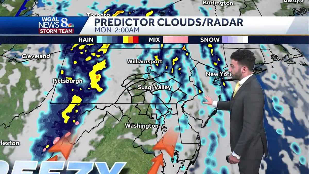
IMPACT: Gusty showers & storms tonight across south-central Pennsylvania
A line of gusty rain showers with low-topped thunderstorms continue to traverse the Susquehanna Valley and will exit eastern counties by 2 AM. Lingering showers are expected for Monday AM with seasonably cool conditions.
BRAND.ORG. TRACKING SOME GUSTY SHOWERS AT THIS TIME ACROSS STORM TEAM LIVE RADAR NETWORK. LET’S ZOOM IN TO SOME OF THESE COMMUNITIES THAT ARE DEALING WITH SOME OF THE HEAVIEST RAIN AT THIS TIME. NOW STARTING TO PUSH OUT OF DAUPHIN COUNTY. BUT HUMMELSTOWN HERSHEY GETTING ALREADY INTO PALMYRA AT THIS TIME GOING INTO LEBANON COUNTY. JUST A LINE OF SOME HEAVY SHOWERS THAT ARE NOW PUSHING EASTWARD, SHIFTING TOWARDS THE SOUTH TOWARDS YORK COUNTY, SEEING A BIT OF A DOWNPOUR, JUST MOVING TO THE EAST OF YORK AT THIS TIME, MOVING NORTH NORTHEAST AT THIS TIME TOWARDS HELLAM TOWNSHIP. AND THEN JUST WIDENING OUT THE PICTURE, I WANT TO SHOW YOU TOWARDS OUR WESTERN COUNTIES, REALLY MORE SO DEALING WITH SOME LIGHTER SHOWERS, BUT EARLIER TOWARDS FRANKLIN COUNTY, ADAMS COUNTY, YOU DEFINITELY GOT SOME. YOU DEFINITELY GOT SOME RAIN EARLIER, ESPECIALLY GETTYSBURG. YOU’RE WATCHING THE SKY CAM A LITTLE BIT. SAW SOME SHEETS OF RAIN COMING DOWN OVER THE THE CENTER SQUARE IN GETTYSBURG. BUT NOW WE’RE SEEING THE MAJORITY OF THAT HEAVY THOSE THAT HEAVY SHOWER ACTIVITY PUSHING TOWARDS THE EAST. SO WHAT WE’RE WATCHING AS WE GO THROUGH THE REST OF THE NIGHT TONIGHT, STILL WATCHING FOR SOME OF THESE DAMAGING OR POTENTIALLY DAMAGING WIND GUSTS WITH THIS LINE OF SOME SHOWERS OR THESE THESE STORMS REALLY. SO THAT’S WHY WE STILL HAVE IT AS AN IMPACT NIGHT UP UNTIL ABOUT 2 A.M. OVERNIGHT TONIGHT. NOW GETTING INTO TOMORROW MORNING, WE’LL SEE SOME LINGERING SHOWERS. SO SOME EARLY RAIN FOR MONDAY. BUT THEN WE WILL BE DRYING OUT FOR THE AFTERNOON. REMAINING COOLER AND BREEZY. AND THEN ONCE WE GET INTO THE REST OF THE WORKWEEK TUESDAY THROUGH THE REST OF THE WEEK HEADING INTO FRIDAY, TEMPERATURES ARE GETTING INTO THE 60S. ALSO SOME 50S IN, SOME IN FOR FOR SOME OF THE DAYS. I’LL SHOW YOU THAT IN A TEN DAY FORECAST, BUT WE’RE GOING TO BE FEELING MUCH MORE SEASONABLE AS WE GET INTO THE NEXT WORK WEEK. NOW, TODAY, HERE’S SOME OF THE WIND GUST REPORTS THAT WE RECEIVED FROM THE NATIONAL WEATHER SERVICE. CHAMBERSBURG, YOU GUSTED TO JUST BELOW THAT 50 MILE PER HOUR BREEZE OR THAT THAT GUST GUST MARK AT 47MPH IN MARION, MANHEIM, SHREWSBURY, MOUNT WOLF, ALL RANGING FROM ALMOST 40 MILES AN HOUR UP TO ALMOST 50MPH TODAY. IN TERMS OF THE WIND GUSTS, CERTAINLY A BREEZY AND WINDY DAY TODAY, AND IT’S GOING TO CONTINUE TO BE BREEZY AS WE GET INTO THE REST OF THE OVERNIGHT PERIOD. NOW, STORMS WILL BE ENDING RIGHT AROUND 2 A.M., BUT THE SHOWERS WILL PERSIST INTO THE NEXT MORNING. STILL HAVE THAT WEST NORTHWESTERLY BREEZE ABOUT 10 TO 15MPH WITH THOSE LINGERING SHOWERS. ALSO, WE’LL SEE SOME DECREASING CLOUDS AS WE GET INTO THE AFTERNOON. WE’LL START TO BREAK OUT INTO PARTLY TO MOSTLY SUNNY CONDITIONS AS WE GET INTO TOMORROW AFTERNOON, WITH BREEZY AND COOLER CONDITIONS REMAINING. NOW THE ALMANAC FOR THE DAY. TODAY WE HIT A HIGH OF 73 DEGREES, STILL MILD FOR THIS TIME OF THE YEAR. IT’S 65 IS WHAT WE EXPECT FOR FOR FOR THIS TIME OF THE MONTH. BUT WE DIDN’T GET ANY RAIN FROM THE LATEST CLIMATE CLIMATOLOGICAL REPORT. BUT AS OF SOME AS THE SHOWERS PASSED BY, I DID SEE A READING OF JUST OVER ABOUT 12 HUNDREDTHS OF AN INCH OF RAIN RECEIVED AT HARRISBURG INTERNATIONAL AIRPORT. NOW, IN TERMS OF YOUR TUESDAY, ANOTHER CHANCE OF SOME SHOWERS, BUT FOR THE EVENING, THE REST REALLY THE THE ENTIRETY OF THE DAY IS GOING TO BE DRY WITH SUNSHINE AND LIGHTER WINDS OUT OF THE SOUTHWEST. LOW POLLEN LEVELS FOR TOMORROW. MOLD LEVELS ARE LOW. LOW UV INDEX FOR THE FOR THE AFTERNOON RAIN CHANCES. NEXT BEST RAIN CHANCE IS GOING TO BE AGAIN EARLY IN THE MORNING TOMORROW AS WE GET INTO TUESDAY LATE IN THE EVENING, THAT’S GOING TO BE OUR NEXT BEST CHANCE OF RAIN. YOU CAN SEE TEMPERATURES INTO THE 60S FOR SOME AREAS. YOU CAN SEE THE DELINEATION OF THAT COLD FRONT PUSHING EASTWARD THROUGH THE SUSQUEHANNA VALLEY. HERE ARE SOME OF THOSE WIND SPEEDS OUT OF THE SOUTH FOR LANCASTER. NOW SWITCHING TOWARDS OR COMING OUT OF THE WEST FOR SOME AREAS LIKE CARLISLE AND GETTYSBURG, AS THAT COLD FRONT CONTINUES TO PUSH THROUGH. BUT IT’S STILL GOING TO BE BREEZY AS WE GET INTO MONDAY AFTERNOON AND MONDAY EVENING. SO WE’RE GOING TO CONTINUE TO WATCH SOME OF THESE SHOWERS. LOOK AT THIS. NOT FOR OUR AREA SOUTH OF WASHINGTON, D.C. THERE’S A TORNADO WARNING THAT’S JUST TO THE SOUTH OF WASHINGTON. SO THAT’S AGAIN, THAT’S GOING TO BE SOMETHING THAT WE’RE GOING TO CONTINUE TO WATCH FOR AS WE GET INTO THE OVERNIGHT PERIOD. NOW, AS WE GET INTO THE OVERNIGHT, AS AS WE GET INTO THE OVERNIGHT HOURS, YOU CAN SEE SOME OF THESE SHOWERS STILL LINGERING AROUND. BUT THEN ONCE WE GET INTO THE AFTERNOON, CHECK THIS OUT. PARTLY TO MOSTLY SUNNY CONDITIONS FOR YOUR EVENING. AND THAT’S JUST GOING TO BE IT’S GOING TO BE STAYING LIKE THAT AS WE GO THROUGH THE REST OF THE DAY, MONDAY AND ALSO INTO TUESDAY. IT’S ONCE WE GET INTO TUESDAY EVENING, I STOP THE CLOCK FOR YOU THERE. THAT’S WHEN WE’LL START TO SEE A FEW MORE EVENING SHOWERS. NOW, ONE MORE THING I WANT TO BRING UP. WE ARE TRACKING THIS TROPICAL SYSTEM THAT’S MAKING ITS WAY INTO THE CARIBBEAN, HAS ABOUT A 70% CHANCE OF DEVELOPMENT, BUT RIGHT NOW IT’S LIMITED IN DEVELOPMENT. ONCE WE GET INTO NEXT WEEK STARTS TO MOVE INTO MORE OF A CONDUCIVE ENVIRONMENT FOR FOR MORE TROPICAL DEVELOPMENT. SO TEMPERATURES INTO THE 60S TO START THE WORKWEEK DOWN INTO THE UPPER 50S F
IMPACT: Gusty showers & storms tonight across south-central Pennsylvania
A line of gusty rain showers with low-topped thunderstorms continue to traverse the Susquehanna Valley and will exit eastern counties by 2 AM. Lingering showers are expected for Monday AM with seasonably cool conditions.

Updated: 10:38 PM EDT Oct 19, 2025
As a slow-moving cold front crosses through the area tonight, gusty rain showers and storms are expected to impact the Valley. This line is expected to exit the area by 2 AM Monday. The Storm Prediction Center highlighted the Susquehanna Valley in a Marginal Risk (a level 1 out of 5) for severe weather with isolated damaging wind gusts & heavy rain as the primary threats. A brief spin-up tornado is possible for eastern counties; however, the threat is very low. Therefore, the News 8 Storm Team has declared tonight as an Impact Night up until 2 AM overnight.Once the cold front pushes through, rain chances stick around through Monday morning as the upper-level system continues swinging across the Commonwealth. So, for your Monday morning commute, expect some lingering showers up until around noon to 1 PM Monday. Skies become sunnier by the afternoon. It will be cooler & breezy, thanks to west-northwest winds of 10 to 20 mph. Winds may gust to 30 mph again. Highs will fall back to more seasonable norms in the low 60s.Expect partly sunny skies Tuesday. Highs are back in the mid 60s. There may be a few showers in the evening, as the next front approaches. In the wake of the front, temperatures drop back to the 50s to around 60-degrees the rest of the week.Next weekend, another system brings rain chances back Saturday with slightly milder temperatures and dry conditions Sunday.Have a safe rest of your night!~ Ryan
As a slow-moving cold front crosses through the area tonight, gusty rain showers and storms are expected to impact the Valley. This line is expected to exit the area by 2 AM Monday. The Storm Prediction Center highlighted the Susquehanna Valley in a Marginal Risk (a level 1 out of 5) for severe weather with isolated damaging wind gusts & heavy rain as the primary threats. A brief spin-up tornado is possible for eastern counties; however, the threat is very low. Therefore, the News 8 Storm Team has declared tonight as an Impact Night up until 2 AM overnight.
Once the cold front pushes through, rain chances stick around through Monday morning as the upper-level system continues swinging across the Commonwealth. So, for your Monday morning commute, expect some lingering showers up until around noon to 1 PM Monday. Skies become sunnier by the afternoon. It will be cooler & breezy, thanks to west-northwest winds of 10 to 20 mph. Winds may gust to 30 mph again. Highs will fall back to more seasonable norms in the low 60s.
Expect partly sunny skies Tuesday. Highs are back in the mid 60s. There may be a few showers in the evening, as the next front approaches. In the wake of the front, temperatures drop back to the 50s to around 60-degrees the rest of the week.
Next weekend, another system brings rain chances back Saturday with slightly milder temperatures and dry conditions Sunday.
Have a safe rest of your night!
~ Ryan