
Impact Day in Western Pa. Thursday ahead of rain changing to snow
Wind chills will be in the single digits for Thursday.
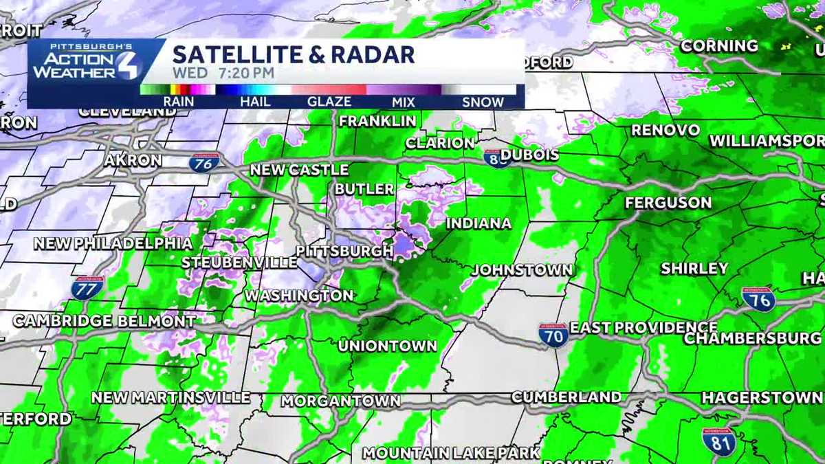
COUNTY RIGHT HERE IN BUTLER. CARLOS FLORES, PITTSBURGH’S ACTION NEWS FOUR. IT HAS BEEN A DAMP DAY, AND NOW WE’RE GOING TO START TO SEE A LITTLE BIT OF SNOW START TO MAKE ITS WAY INTO TOWN AS WE HEAD OVERNIGHT. RIGHT NOW WE’RE DOWN TO 36 DEGREES, SO GETTING CLOSER TO SEEING SOME SNOW OUT THERE FEELS LIKE 30 DEGREES WITH THE WINDS WEST SEVEN MILES PER HOUR. TEMPERATURE RIGHT NOW 36. IN NEW CASTLE, CRANBERRY AND MONROEVILLE, AS WELL AS KITTANNING, 36, IN WASHINGTON AND 38 IN WAYNESBURG. AND THOSE TEMPERATURES WILL CONTINUE TO DROP OFF AS WE HEAD INTO TOMORROW. WE’LL HAVE A HIGH TEMPERATURE IN THE AFTERNOON, AROUND 20 DEGREES, BUT MOST OF THE DAY WE WILL BE IN THE TEENS AND WITH THE WIND GUSTS WILL BE EXPERIENCING TOMORROW. THAT WILL TAKE YOUR WIND CHILLS DOWN REALLY INTO THE SINGLE DIGITS FOR THE MAJORITY OF THE DAY. SO IMPACT DAY ON THURSDAY BECAUSE OF THE COLD AIR, THE WIND AND THE BIT OF SNOW WILL HAVE FOR THE MORNING COMMUTE. AND THEN ON FRIDAY WE’RE ALL THE WAY DOWN TO 14 DEGREES. THIS IS GOING TO BE A LONG DURATION OF COLD AIR THAT WILL BE EXPERIENCING AS WE GO THROUGH THE WEEKEND AND INTO NEXT WEEK. 15 FOR YOUR LOW ON SUNDAY, 12 ON MONDAY, AND THEN WE’RE DOWN TO SIX DEGREES FOR A LOW TEMPERATURE ON TUESDAY AS WELL AS WEDNESDAY. WEDNESDAY WE’LL HAVE ANOTHER SHOT AT SEEING SOME LIGHT SNOW SHOWERS, SO WE’RE JUST BEGINNING TO SEE THAT RAIN START TO CHANGE OVER TO SNOW ACROSS THE AREA. PRETTY MUCH RIGHT ON TIME. AND WE HAVE MORE OF THAT SNOW THAT IS GOING TO BE MOVING THROUGH. NOT EXPECTING A LOT IN THE WAY OF ACCUMULATION. PITTSBURGH MAYBE AN INCH, POSSIBLY TWO. IN SOME LOCATIONS WE WILL HAVE LAKE EFFECT BANDS MOVING IN LAKE EFFECT SNOW. AND IN THOSE BANDS, OF COURSE, YOU COULD HAVE A BRIEF HIT OF HEAVY SNOW AND LOW VISIBILITY. OTHERWISE, WE’RE LOOKING AT ONE INCH OF SNOW, TWO INCHES OF SNOW IN AND AROUND PITTSBURGH, AND THEN IN THE OUTLYING AREAS, LAUREL HIGHLANDS AND UP ALONG I-80 AND THOSE LOCATIONS, YOU CAN SEE 2 TO 4IN OF SNOW AS WE GO THROUGH FRIDAY. WE MAY HAVE A FEW FLURRIES. THAT’S PRETTY MUCH IT. AND THEN WE TAKE IT TO SATURDAY. WE’LL HAVE ANOTHER ROUND OF SNOW, BUT AGAIN, THIS WILL BE FAIRLY LIGHT SNOW THAT WILL BE EXPERIENCING OVER THE WEEKEND. AS FAR AS THE WIND CHILLS GO, WE’LL BE SEEING THOSE TOMORROW MORNING THAT WILL BE DROPPING DOWN AROUND ZERO, SO IT’S GOING TO BE VERY COLD WHEN WE WALK OUT THE DOOR AND AS WE GO THROUGH THE NEXT FOUR DAY PLUS FOUR MORE IMPACT DAY ON THURSDAY. BUT REALLY EACH OF THESE DAYS IT IS GOING TO B
Impact Day in Western Pa. Thursday ahead of rain changing to snow
Wind chills will be in the single digits for Thursday.

Updated: 7:34 PM EST Jan 14, 2026
Rain to snow showers todayColder air will rush into the area to allow for rain to transition to snow. All of us will see snow as temperatures drop. Most locations will see an inch of snow or less. The exceptions will be the Interstate 80 corridor and Laurel Highlands where lake effect snow could mean up to three inches are possible by the end of snow Thursday afternoon.Impact Day tonight into ThursdaySnow showers will last into Thursday will not accumulate too much but it only takes a light dusting to cause hazardous road conditions. As air temperatures drop, eventually the road temperatures will drop as well. Anything left untreated overnight and into Thursday could get icy for the Thursday AM commute.. A Winter Weather Advisory is in effect for the Laurel Highlands due to snow and travel concerns.Highs on Thursday will top out around 20°. Wind gusts could reach 30 mph which will take wind chills, through the entire day Thursday, will be in the single digits. Snow will taper off in the afternoon with winds dying down into Friday morning.Weekend flurries then even colderAnother system will pass over the Great Lakes on Saturday to allow for flurries or light snow showers across Western PA. At this time, little accumulation is expected. This system will usher in colder air to finish the weekend as highs drop into the 20s. Lows will drop into the teens and even single digits for the middle of next week.OVERNIGHT- IMPACT DAY: Scattered snow showers, cold. Low 16°THURSDAY – IMPACT DAY: Flurries to light snow showers, windy. High: 20°, low: 14°. Wind chills near 0°FRIDAY: Cloudy with flurries. High: 33°, low: 25°.
PITTSBURGH — Rain to snow showers today
Colder air will rush into the area to allow for rain to transition to snow. All of us will see snow as temperatures drop. Most locations will see an inch of snow or less. The exceptions will be the Interstate 80 corridor and Laurel Highlands where lake effect snow could mean up to three inches are possible by the end of snow Thursday afternoon.

Impact Day tonight into Thursday
Snow showers will last into Thursday will not accumulate too much but it only takes a light dusting to cause hazardous road conditions. As air temperatures drop, eventually the road temperatures will drop as well. Anything left untreated overnight and into Thursday could get icy for the Thursday AM commute.. A Winter Weather Advisory is in effect for the Laurel Highlands due to snow and travel concerns.

Hearst Owned
Winter Weather Advisory for Venango, Forest, Westmoreland, Fayette, Monongalia, Preston, and Garrett counties.
Highs on Thursday will top out around 20°. Wind gusts could reach 30 mph which will take wind chills, through the entire day Thursday, will be in the single digits. Snow will taper off in the afternoon with winds dying down into Friday morning.

Hearst Owned
Wind chills will be a couple degree either side of zero Thursday morning.
Weekend flurries then even colder
Another system will pass over the Great Lakes on Saturday to allow for flurries or light snow showers across Western PA. At this time, little accumulation is expected. This system will usher in colder air to finish the weekend as highs drop into the 20s. Lows will drop into the teens and even single digits for the middle of next week.

Hearst Owned
Snow showers into the weekend then even colder next week.
OVERNIGHT- IMPACT DAY: Scattered snow showers, cold. Low 16°
THURSDAY – IMPACT DAY: Flurries to light snow showers, windy. High: 20°, low: 14°. Wind chills near 0°
FRIDAY: Cloudy with flurries. High: 33°, low: 25°.