

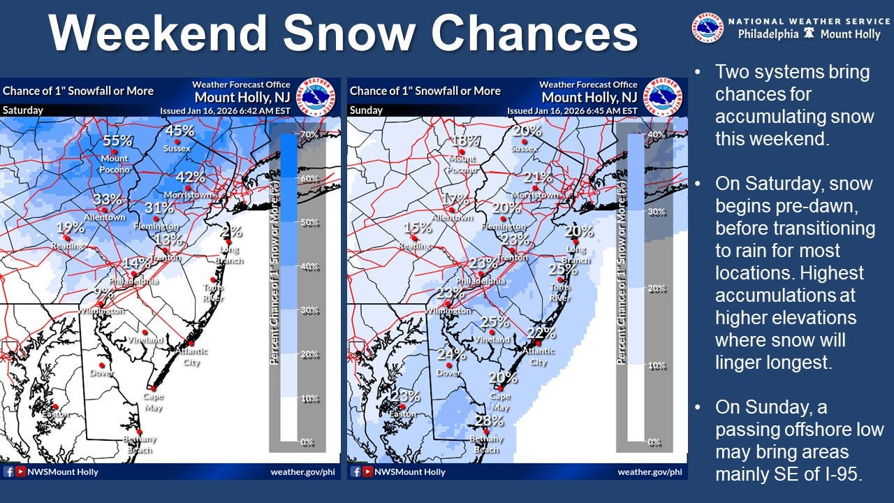
Two winter storm fronts will bring two separate chances for snow to the greater Philadelphia area this weekend, according to forecasters.
While the overall likelihood of significant accumulation is low, there is a possibility of some depending on the track of the storms.
The first front will arrive overnight Friday into the early morning hours of Saturday, according to the National Weather Service.
Find out what’s happening in Across Pennsylvaniafor free with the latest updates from Patch.
The storm will continue into the afternoon, until possibly mixing with rain or turning into rain by 4 p.m., forecasters said.
The agency gives most of the Philadelphia region about a 15 to 20 percent chance of accumulation of an inch or more. The total will be largely dependent upon how cool it can stay later in the day.
Find out what’s happening in Across Pennsylvaniafor free with the latest updates from Patch.
A second front will arrive from the coast on early Sunday morning, with a slight chance of rain or snow overnight and then a slightly higher chance after 7 a.m., forecasters said.
Areas to the southeast of I-95 are more likely to see additional accumulation. Snow could continue into the afternoon.
The city and immediate suburbs have about a 23 percent chance of another inch of accumulation, while the likelihood drops to around 15 percent for suburbs west and north.
Regardless of the final accumulation, the conditions will be significant enough to cause issues on the roads, even if it’s mostly freezing rain that falls. Temperatures will plummet to 21 overnight Sunday and then down to 12 Monday, meaning that remaining moisture on roads could quickly freeze over.
“The conditions may be wintry enough to prompt aircraft deicing operations, which can delay flights,” Accuweather added.
The same storm is expected to be much more severe in western Pennsylvania and parts of New York state, dropping a foot more in places, according to Accuweather.
Here’s the full forecast for the coming week, according to the National Weather Service:
Today
Sunny, with a high near 35. West wind 10 to 15 mph.
Tonight
A chance of snow, mainly after 4 a.m. Increasing clouds, with a low around 29. South wind 5 to 10 mph. Chance of precipitation is 30 percent. New snow accumulation of less than a half inch possible.
Saturday
Snow likely, possibly mixed with rain before 4pm, then a chance of rain. Mostly cloudy, with a high near 42. South wind 5 to 10 mph. Chance of precipitation is 60 percent. New snow accumulation of less than a half inch possible.
Saturday Night
A slight chance of rain between 1 a.m. and 4 a.m., then a slight chance of snow after 4 a.m. Mostly cloudy, with a low around 30. Southwest wind around 5 mph becoming calm. Chance of precipitation is 20 percent.
Sunday
A chance of snow, mainly after 7 a.m. Mostly cloudy, with a high near 35. West wind around 5 mph. Chance of precipitation is 30 percent. New snow accumulation of less than a half inch possible.
Sunday Night
Partly cloudy, with a low around 21.
M.L.King Day
Sunny, with a high near 35.
Monday Night
Mostly clear, with a low around 12.
Tuesday
Sunny, with a high near 23.
Tuesday Night
Mostly clear, with a low around 12.
Wednesday
Mostly sunny, with a high near 32.
Wednesday Night
Mostly cloudy, with a low around 27.
Thursday
Partly sunny, with a high near 40
Get more local news delivered straight to your inbox. Sign up for free Patch newsletters and alerts.