
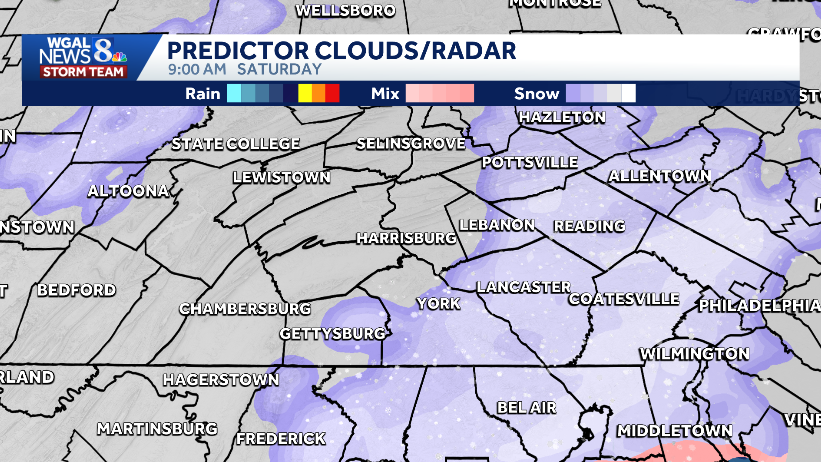
Hour-by-hour snow projections for the Susquehanna Valley
CONDITIONS EARLY TOMORROW MORNING. SO I’VE HIGHLIGHTED THAT AS AN IMPACT. MORNING FOR YOU TOMORROW. STORM TEAM LIVE RADAR NETWORK RIGHT NOW. ALREADY STARTING TO SEE SOME CLOUDS SCOOTING INTO OUR WESTERN COUNTIES WHILE IT’S CLEAR EAST SERIES OF FRONTS LINING UP IN THE MIDWEST, PACKING SOME SNOW SHOWERS, PACKING SOME COLDER AIR. AND THAT’S WHAT’S COMING FOR US AS WE HEAD INTO TONIGHT AND TOMORROW. SO HERE’S THE PREDICTOR. NOTICE CLOUDS INCREASING THIS MORNING. THICKENING THIS AFTERNOON. MIGHT SEE A FEW BREAKS AS THE SUN GOES DOWN, BUT THAT’S ONLY TEMPORARY. I DO THINK THE CLOUDS COME BACK IN TONIGHT. AND THIS IS AT 1 A.M. ON SATURDAY. SOME SCATTERED SNOW SHOWERS WILL BE AROUND IN THE OVERNIGHT HOURS. BETTER CHANCE FOR SOME LIGHT SNOW AS A COLD FRONT APPROACHES AROUND SUNRISE TOMORROW. NOTICE, ESPECIALLY ALONG AND EAST OF THE SUSQUEHANNA RIVER. THAT’S WHERE WE’LL SEE SOME STEADY LIGHT SNOW FOR AN HOUR OR TWO, MAYBE THREE HOURS AT THE MOST. PUTTING DOWN A QUICK COATING TO AROUND AN INCH OF SNOW, AND THEN THAT EXITS BY LUNCHTIME. IT’S OUT OF HERE LATER IN THE DAY, AND MAYBE A RAIN OR SNOW SHOWER LATER IN THE DAY ON SATURDAY, BUT TEMPERATURES WILL BE WELL ABOVE FREEZING FOR SUNDAY. LOW PRESSURE DEVELOPS OFFSHORE. MOST OF THAT SNOW STAYS WELL TO OUR EAST. WON’T RULE OUT A FLURRY OR TWO HERE, BUT SUNDAY DOES LOOK LIKE A QUIETER DAY FOR US, BUT A COLDER ONE. HERE’S A LOOK AT THE PREDICTOR. ESTIMATED SNOWFALL TOTALS FOR SATURDAY MORNING. MOST SPOTS AGAIN COATING TO AN INCH. AND THEN IT IS GONE. TEN DAY FORECAST. WE ARE GOING TO SEE SOME SIGNIFICANT COLDER AIR NEXT WEEK. MONDAY AN ARCTIC FRONT COMES THROUGH AND LOOK AT TUESDAY’S HIGH. ONLY 22 DEGREES. WE COULD HAVE SUBZERO WIND CHILLS TUESDAY MORNING. THAT’S GOING TO STING. AND THEN AS WE HEAD INTO WEDNESDAY, WINDS RELAX A LITTLE BIT. THURSDAY AND FRIDAY LOOK A BIT MORE SEASONABLE WITH A CHANCE FOR SOME RA
Hour-by-hour snow projections for the Susquehanna Valley

Updated: 12:11 PM EST Jan 16, 2026
A fast-moving clipper will bring light snow to South-Central Pennsylvania Saturday morning.The winter storm is expected to produce a coating to one inch of snow, with some isolated amounts of two inches at elevation.The snow could cause slick roads before conditions improve.Timing and snowfallSaturday morning: light snow arrives early and tapers by noon.Snow totals: coating to one inch with isolated pockets near two inches in northeast counties at elevation.ImpactsTravel: slick or slushy roads possible early Saturday; plan for slower commutes.Afternoon recovery: conditions improve quickly as highs rise into the upper 30s Saturday afternoon.Sunday outlookChance: a few snow showers or flurries possible as low pressure develops offshore, but likelihood is decreasing as the storm tracks farther out to sea.Sky/temps: mostly cloudy with clearing late; highs around 30 degrees with a brisk breeze.
A fast-moving clipper will bring light snow to South-Central Pennsylvania Saturday morning.
The winter storm is expected to produce a coating to one inch of snow, with some isolated amounts of two inches at elevation.
The snow could cause slick roads before conditions improve.
Timing and snowfallSaturday morning: light snow arrives early and tapers by noon.Snow totals: coating to one inch with isolated pockets near two inches in northeast counties at elevation.Impacts
Travel: slick or slushy roads possible early Saturday; plan for slower commutes.Afternoon recovery: conditions improve quickly as highs rise into the upper 30s Saturday afternoon.
Sunday outlookChance: a few snow showers or flurries possible as low pressure develops offshore, but likelihood is decreasing as the storm tracks farther out to sea.Sky/temps: mostly cloudy with clearing late; highs around 30 degrees with a brisk breeze.