
All of us should see some snow and rain showers at some point over the weekend, so be prepared with everything from umbrellas to snow shovels. Also leave extra drive time with slippery roads across the region.
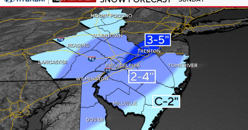
2-4″ of snow possible for Philly and either side of the I-95 corridor.

CBS News Philadelphia
A coastal low will pass close enough for another round of snow and rain mainly I-95 and areas south and east. Light early morning snow is possible north and west of the city with rain for I-95 and South Jersey. By late morning, the rain will change to snow over South Jersey and I-95.

CBS News Philadelphia
As the coastal low moves away from our area in the afternoon any snow will shift to South Jersey. Two inches of snow is possible for inland South Jersey and the Shore.
Less snow in the northwest, a little more northeast—toward Trenton, we could see a few bands setting up to get up to 5″ in a few spots.
NEXT big weather change
A NEXT Weather Alert on Tuesday for dangerous cold: Tuesday the coldest air of the season arrives. Morning lows will range from 5 to 15 and wind chills from -15 to 15. Daytime highs on Tuesday will range from 15 to 25 with winds chills continuing in the teens and single digits.
All skin must be covered to avoid frostbite. Special care for pets.
Here’s your 7-day forecast:

CBS News Philadelphia
Sunday: NEXT Weather Alert for rain and snow. High 35, low 32.
Monday/MLK Day: Mostly sunny and cold. High 37, low 19.
Tuesday: NEXT Weather Alert for the coldest weather of the season. High 25, low 17.
Wednesday: Partly cloudy. High 41, low 12.
Thursday: Mostly cloudy. High 44, low 33.
Friday: Partly cloudy. High 38, low 26.
Saturday: Chance of snow. High 33, low 28.