
SHORT TERM FORECAST
MONDAY: Partly to mostly sunny, cold, and turning breezy. High: 32
MONDAY NIGHT: Mainly clear, brisk, and quite cold. Low: 10
THE BIG PICTURE
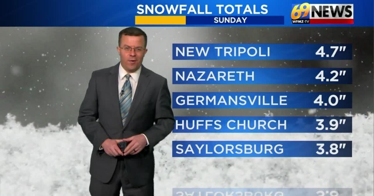
The region saw yet another bout of snow on Sunday, this time thanks to a low-pressure system lifting northeastward offshore. Temperatures throughout much of the day Sunday held steady either side of 32 degrees. While snowfall totals Sunday weren’t quite as much as Saturday, many still saw at least a couple inches leading to some slippery roads in the morning. Adding up both Saturday and Sunday’s snow totals, much of the region saw anywhere from 4 to 7 inches of snow. A little additional snow is possible early on this evening before things come to an end for good tonight. We now turn our attention to an incoming blast of arctic air early in the new week. The core of the cold arrives Monday night and lasts through Wednesday morning, with lows eventually in the single digits and highs only around 20 degrees, and some near or below zero wind chills at night and early each morning. It’s mostly dry for the new work and school week, but it’s cold throughout, with the coldest weather the first half of the week and more seasonable cold later in the week. Snow chances could increase again next weekend.
FORECAST DETAILS
TONIGHT
While there was a decent lull in the snow for a while Sunday, some steady light snow is picking back up across far eastern Pennsylvania and much of New Jersey as low pressure offshore gathers a little strength lifting further to the northeast. The National Weather Service does continue a Winter Weather Advisory until early this evening for the Lehigh Valley, Berks, Lebanon, and Lancaster counties, the Delaware Valley, northern Delaware, southwestern New Jersey, and central and northern New Jersey. Another coating to as much as 1.5″ of snow will be possible on top of what you’ve already received. The further east one travels into New Jersey, like the more snow you will see. Some roads, certainly secondary, could become a little slick again. After 8pm tonight, the snow should come to an end and we’ll see some gradually clearing skies as overnight low temperatures dip down to some pretty cold levels in the mid teens. Watch for a refreeze of any leftover standing water or slush on untreated surfaces.
TRACK THE WEATHER:
LINKS: HOUR BY HOUR | RADAR | TRAFFIC