
IMPACT DAY | Temperatures plummet as wind chills drop below zero in south-central Pennsylvania
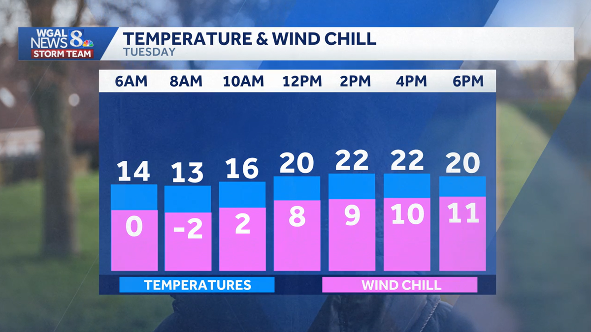
TO REBUILD THAT BRIDGE, BUT IT NEVER RAISED ENOUGH MONEY. 509 AND WE CERTAINLY HAD SOME SNOW OVER THE WEEKEND, AND NOW WE ARE DEALING WITH THE COLD, COLD TEMPS THIS MORNING. THE WINDCHILL. THAT’S WHAT WILL IMPACT YOU FOR SURE TODAY. SO LET ME SHOW YOU WHAT WE HAVE RIGHT NOW. WE HAVE THIS BRISK BREEZE COMING OUT OF THE NORTHWEST AT ABOUT 10 TO 15MPH IN SOME SPOTS. AND THAT IS WHAT’S DRIVING OUR WIND CHILLS DOWN TO NEAR ZERO BECAUSE IT’S JUST SO COLD OUTSIDE. IT’S NINE IN LEWISTOWN. IT’S 16 IN GETTYSBURG, 14 IN HARRISBURG, 11 RIGHT NOW IN LANCASTER. AND THEN THE WIND SPEEDS THERE ABOUT 10 TO 20MPH THROUGHOUT THE DAY. SO THAT IS CERTAINLY GOING TO KEEP OUR WIND CHILLS BELOW ZERO THIS MORNING AND THEN GIVE A SINGLE DIGIT CHILLS THIS AFTERNOON. SO OUR FEELS LIKE TEMPERATURES RIGHT NOW, ONE BELOW IN CHAMBERSBURG AND SELINSGROVE. SEVEN BELOW IN LEWISTOWN, ZERO IN LANCASTER. AND THOSE NUMBERS COULD GET COLDER. SO HERE’S A LOOK AT YOUR TEMPERATURE IN THE BLUE BOXES. WE ONLY GET TO 22 TODAY. AND THE WIND CHILL THROUGHOUT THE DAY. NEAR ZERO OR SUBZERO THIS MORNING. AND SINGLE DIGIT CHILLS LATER THIS AFTERNOON. NOW THE GOOD NEWS IS THAT WINDS DO DIMINISH AS WE HEAD TOWARD EVENING, SO BE PREPARED. DRESS IN LAYERS THIS MORNING. THIS AFTERNOON, TEMPERATURES WILL REACH 22 BETWEEN HOURS THERE WITH THE SINGL
IMPACT DAY | Temperatures plummet as wind chills drop below zero in south-central Pennsylvania

Updated: 5:22 AM EST Jan 20, 2026
Bitterly cold air and sub-zero wind chills across south-central Pennsylvania have made Tuesday an Impact Day.The WGAL News 8 Storm Team is tracking a cold front moving into the Susquehanna Valley.Bitter cold temperaturesMorning: Temperatures in the teens; 10 to 20 mph winds; Wind chills below zero to near zero. Afternoon: Mostly sunny skies; Highs reach the low 20s; Winds remain brisk, keeping wind chills in the single digits. Night: Winds diminish; Temperatures plummet to the single digits under mostly clear skies. Safety precautions Dress in warm layers and cover exposed skin; wear a hat and gloves. Limit time outdoors when possible. Check on vulnerable neighbors, friends, and family, and bring pets indoors. Protect outdoor plumbing and check exposed pipes for freezing. Stay weather aware with WGAL’s online toolsRADAR: Track severe weather with WGAL’s interactive radar.LOCATION-BASED ALERTS: Instructions for activating our customized weather alerts are here.CLOSINGS: When severe weather strikes, see if businesses, churches or organizations have closed or delayed.ROAD CLOSURES: Our interactive traffic map is always updated with crashes, construction and road closures. It even has a weather radar overlay.EMAIL ALERTS: We’ll send you daily updates, or just alerts when severe weather is headed your way.HOUR-BY-HOUR: See what you can expect every day with the hourly forecast.WEEKEND WEATHER: Know what to expect before you make your plans.10-DAY FORECAST: Check WGAL’s extended forecast here.
Bitterly cold air and sub-zero wind chills across south-central Pennsylvania have made Tuesday an Impact Day.
The WGAL News 8 Storm Team is tracking a cold front moving into the Susquehanna Valley.
Bitter cold temperatures
Morning: Temperatures in the teens; 10 to 20 mph winds; Wind chills below zero to near zero.
Afternoon: Mostly sunny skies; Highs reach the low 20s; Winds remain brisk, keeping wind chills in the single digits.
Night: Winds diminish; Temperatures plummet to the single digits under mostly clear skies.
Safety precautions Dress in warm layers and cover exposed skin; wear a hat and gloves. Limit time outdoors when possible. Check on vulnerable neighbors, friends, and family, and bring pets indoors. Protect outdoor plumbing and check exposed pipes for freezing. Stay weather aware with WGAL’s online tools