

There is “increasing potential” of a major snow event in eastern Pennsylvania this coming weekend, with five inches of accumulation or more impacting the region, according to the National Weather Service.
The storm will arrive Saturday afternoon and continue through the weekend into Sunday night, forecasters said.
Precise details on the storm remain unclear and could take better shape in the coming days.
Find out what’s happening in Across Pennsylvaniafor free with the latest updates from Patch.
“While it is too early for specifics, potential exists for substantial snow accumulations, primarily Saturday night through Sunday,” the National Weather Service’s Mt. Holly, New Jersey branch shared.
The agency believes there is roughly a 55 percent chance that Philadelphia and the immediate suburbs could receive 5 inches or more. Areas to the north and west have a slightly lower probability, of about 45 percent.
Find out what’s happening in Across Pennsylvaniafor free with the latest updates from Patch.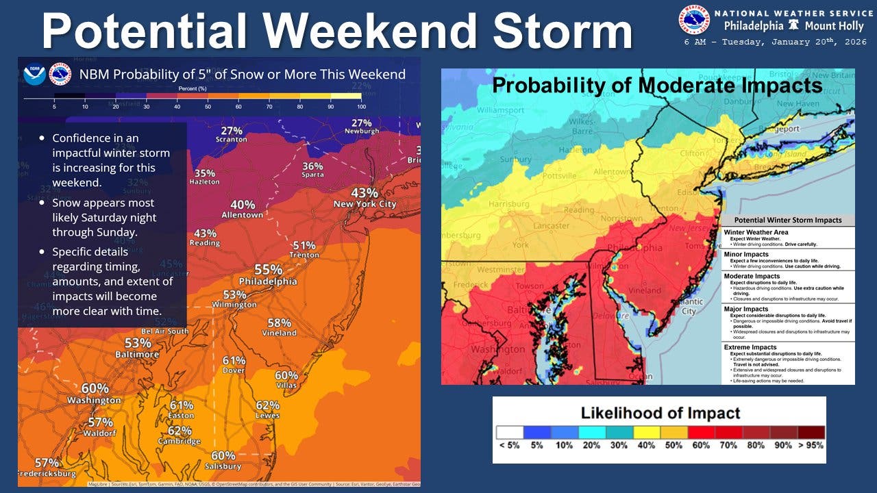
At least “moderate” impacts are expected, which include hazardous driving conditions, ice, potential whiteouts, and closures of schools and businesses.
The stage will be set for a powerful storm due to the frigid air that will already be in place this week before the front arrives.
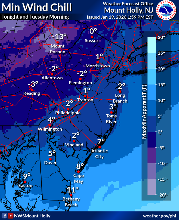
Temperatures will not escape the low 20s on Tuesday, and mostly chilly weather is on tap for the rest of the week. The wind chill plummeted down to near zero through much of the region early Tuesday.
By Friday night before the storm front is set to arrive, temperatures will drop to 11. The high on Saturday is expected to be 19, and 21 on Sunday.
“The ingredients are coming into place for a long-duration storm that brings a substantial amount of snow,” for numerous states, Accuweather Senior Meteorologist Alex Sosnowski said.
Here’s the full forecast, according to the National Weather Service:
Tuesday
Sunny, with a high near 23. West wind 10 to 15 mph.
Tuesday Night
Mostly clear, with a low around 12. West wind around 5 mph becoming calm after midnight.
Wednesday
Mostly sunny, with a high near 36. Light south wind increasing to 10 to 15 mph in the morning.
Wednesday Night
Mostly cloudy, with a low around 31. Southwest wind around 10 mph.
Thursday
Mostly sunny, with a high near 45. Southwest wind 5 to 10 mph, with gusts as high as 20 mph.
Thursday Night
Partly cloudy, with a low around 25.
Friday
Partly sunny, with a high near 35.
Friday Night
Mostly cloudy, with a low around 11.
Saturday
A chance of snow after 1 p.m. Partly sunny, with a high near 19. Chance of precipitation is 30 percent.
Saturday Night
A chance of snow. Mostly cloudy, with a low around 12. Chance of precipitation is 50 percent.
Sunday
Snow likely. Mostly cloudy, with a high near 21. Chance of precipitation is 60 percent.
Sunday Night
A chance of snow. Mostly cloudy, with a low around 11. Chance of precipitation is 40 percent.
Monday
Mostly sunny, with a high near 22.
Get more local news delivered straight to your inbox. Sign up for free Patch newsletters and alerts.