
We’ll see morning sunshine today and bitterly cold temperatures ranging from the single digits to sub-zero readings. Right now, temperatures are the coldest in Lancaster County, where there is still quite a bit of snow on the ground.Look for increasing clouds this afternoon and highs around 34 degrees. It will turn breezy again as a warm front moves north. A few flurries or a snow shower is possible this evening, mainly north and west of Harrisburg.Tonight, lows will hold steady around 30 degrees. Much warmer than this morning! A stray snow shower is possible.A weak cold front will pass early Thursday, with the slim chance of a snow shower. Otherwise, we’ll get a break in the cold, as highs climb to 42 degrees under partly sunny skies.Another arctic airmass will move into the Susquehanna Valley Friday, knocking highs down to 34 degrees. Winds will increase to 15-25 mph in the afternoon, making it feel like the 20s.Highs will reach 18 degrees on Saturday and Sunday. We’re watching a large winter storm, which will pass through the Mid-Atlantic late Saturday night through Monday morning. At this time, Pennsylvania is in a good position for plowable snowfall, and possible high snow totals. We’ll have a better idea of track, timing, and impacts today and Thursday. Snow totals will come into view on Friday morning, so please stay tuned!Early next week, highs will remain in the low 20s, along with blustery winds and frigid overnight lows in the single digits to low teens. Wind chills will have to be monitored, as they could be near or below zero at times.Arctic air remains entrenched over the area through the end of next week.
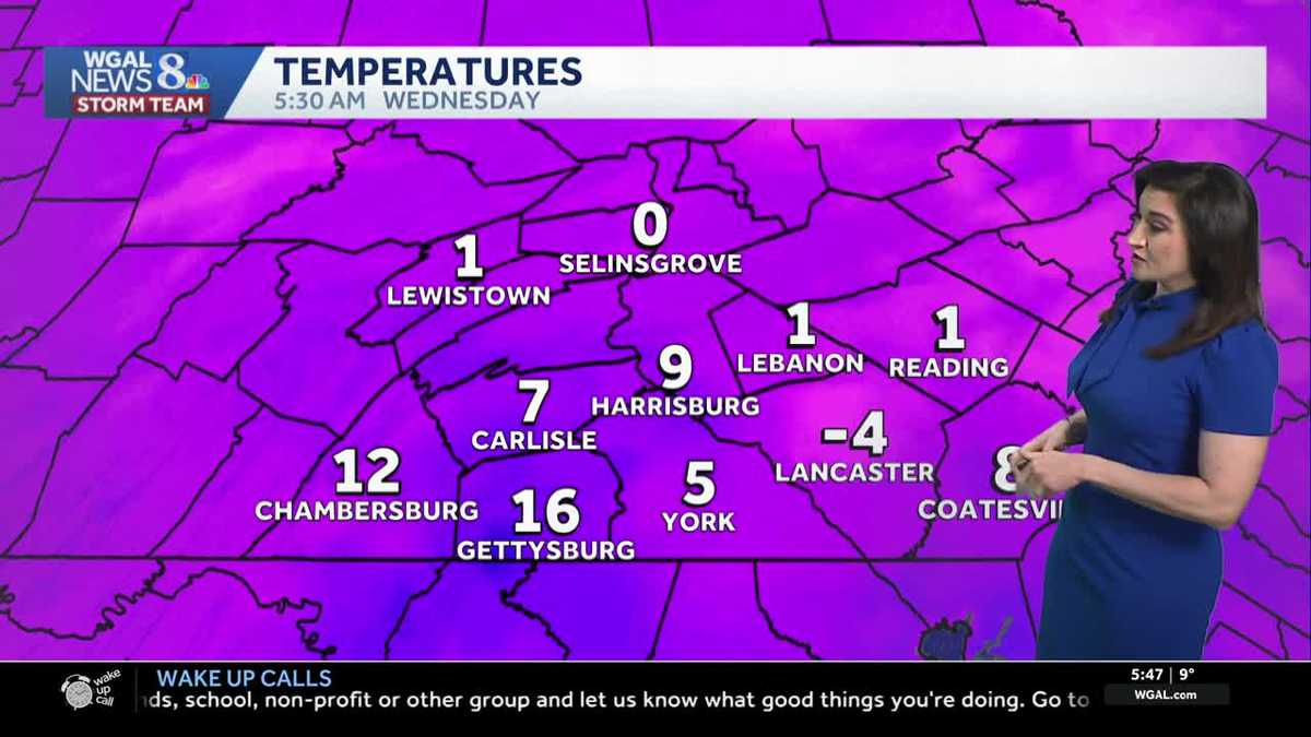
We’ll see morning sunshine today and bitterly cold temperatures ranging from the single digits to sub-zero readings. Right now, temperatures are the coldest in Lancaster County, where there is still quite a bit of snow on the ground.
Look for increasing clouds this afternoon and highs around 34 degrees. It will turn breezy again as a warm front moves north. A few flurries or a snow shower is possible this evening, mainly north and west of Harrisburg.
Tonight, lows will hold steady around 30 degrees. Much warmer than this morning! A stray snow shower is possible.
A weak cold front will pass early Thursday, with the slim chance of a snow shower. Otherwise, we’ll get a break in the cold, as highs climb to 42 degrees under partly sunny skies.
Another arctic airmass will move into the Susquehanna Valley Friday, knocking highs down to 34 degrees. Winds will increase to 15-25 mph in the afternoon, making it feel like the 20s.
Highs will reach 18 degrees on Saturday and Sunday. We’re watching a large winter storm, which will pass through the Mid-Atlantic late Saturday night through Monday morning. At this time, Pennsylvania is in a good position for plowable snowfall, and possible high snow totals. We’ll have a better idea of track, timing, and impacts today and Thursday. Snow totals will come into view on Friday morning, so please stay tuned!
Early next week, highs will remain in the low 20s, along with blustery winds and frigid overnight lows in the single digits to low teens. Wind chills will have to be monitored, as they could be near or below zero at times.
Arctic air remains entrenched over the area through the end of next week.