
AND TEMPERATURES WILL BE MILDER. THEY’RE GOING TO BE THE WARMEST OF THE WEEK IN THE LOWER 40S. NOW ON FRIDAY, HERE COMES A DRY BOUNDARY. THAT’S THE ARCTIC AIR. AND THE WIND WILL PICK UP FRIDAY AFTERNOON, USHERING IN THAT ARCTIC AIR JUST IN TIME FOR THE WEEKEND. SO WITH THAT ARCTIC AIR IN PLACE, YOU CAN SEE THE ARCTIC HIGH OVER THE NORTHEAST THAT’S GOING TO HOLD OFF THE STORM JUST A LITTLE BIT. TIMING IS STILL IN QUESTION ON SUNDAY, WHERE THIS SNOWSTORM STARTS. IS IT SATURDAY NIGHT? IS IT SUNDAY MORNING? WE’RE STILL WORKING ON THOSE DETAILS, BUT THE CONFIDENCE IS GROWING. THAT LOW PRESSURE WILL MOVE OFF THE MID-ATLANTIC COAST, PUTTING US IN THAT SWEET SPOT FOR SNOW. SO WE ARE LOOKING AT A PLOWABLE SNOW ON SUNDAY. POSSIBLY COULD BE SOME HIGHER TOTALS. WE WILL KEEP YOU POSTED AS TOTALS WILL COME OUT ON FRIDAY AND WE WILL HAVE BETTER DETAILS AS HIGHER RESOLUTION MODELING COMES IN OVER THE COMING DAYS. BUT BEHIND THAT STORM, IT’S JUST GOING TO BE DOWNRIGHT FRIGID. SO IT’S GOING TO BE HARD TO GET CLEANED UP FROM THE STORM BECAUSE TEMPERATURES WILL BE SO COLD. SO HERE’S WHAT WE KNOW ARCTIC AIR IS IN PLACE. PRECIPITATION WILL BE ALL SNOW SUNDAY, POSSIBLY LINGERING INTO MONDAY MORNING. AND THEN THIS IS A PLOWABLE SNOW. IT’S LIKELY HIGH TOTALS ARE POSSIBLE AND THE SNOW IS GOING TO BE VERY LIGHT AND FLUFFY. IT’S NOT GOING TO BE THAT HEAVY, WET SNOW THAT WE SAW OVER THE WEEKEND. ROAD CONDITIONS. YOU CAN EXPECT SNOW COVERED ROADS EASILY. THAT’S A LOCK. TRANSIT DELAYS WILL BE HIGH, COULD HAVE SOME LOW VISIBILITY IF THE SNOW COMES DOWN AT A HEAVY CLIP, BUT THAT REMAINS TO BE SEEN. AND THEN POWER OUTAGE CHANCE LOW. NOT EXPECTING MUCH WIND WITH THIS STORM. IT’S NOT A NOR’EASTER OR A CLASSIC WINDSTORM WITH THE SNOW. AS FAR AS OUR CONFIDENCE GO. ALL SNOW. I THINK THAT’S A LOCK FOR US. TIMING. WE’RE MODERATELY CONFIDENT ON THAT SUNDAY INTO MONDAY, AND THEN THE TRACK MODERATELY CONFIDENT TRACK THAT IT MOVES OFF THE EAST COAST, BUT TOTALS STILL LOW BECAUSE WE DON’T HAVE THAT HIGH RESOLUTION DATA UNTIL WE GET TOWARD THE END OF THE WEEK. HERE’S A LOOK AT OUR TEN DAY FORECAST. TEMPERATURES THAW OUT NEXT COUPLE OF DAYS JUST A LITTLE BIT, BUT THEN WE REALLY SEE THE SURGE OF ARCTIC AIR, WHICH OOPS SORRY ABOUT THAT, STAYS IN PLACE AS WE HEAD INTO THE WEEKEND AND BEYOND INTO NEXT WEEK. SO THAT’S REALLY THE KEY. REGINA CONSIDERING, YOU KNOW, WE GET SOME SNOW ON SUNDAY THAT’S GOING TO REALLY GIVE US COLD TEMP
Chance of significant snow is in the forecast for this weekend | What we know, and don’t know, right now

Updated: 11:34 AM EST Jan 21, 2026
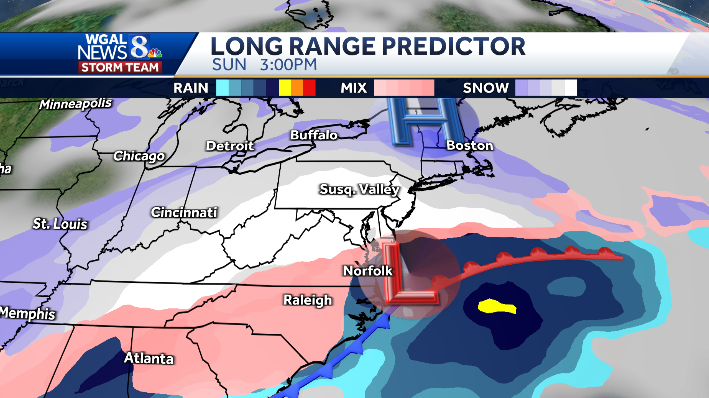
A chance of significant snow is in the forecast this weekend in South-Central Pennsylvania. “Timing is still in question on Sunday, (when) this snow storm starts. Is it Saturday night? Is it Sunday morning? We’re still working on those details, but the confidence is growing,” WGAL Chief Meteorologist Christine Ferreira said. Christine says the Susquehanna Valley could see higher snowfall totals, but more precise accumulation estimates won’t be available until later this week.”We will keep you posted as totals will come out on Friday. And we will have better details as higher resolution modeling comes in over the coming days,” Christine said. The WGAL News 8 Storm Team has designated Sunday as an Alert Day, meaning the day could feature the threat of extreme, severe, and possibly life-threatening weather. Monday is an Impact Day, meaning the day’s weather could disrupt your normal daily schedule or routine.When does the snow start?Still uncertain: could begin Saturday night or Sunday morning.Low pressure likely moves off the Mid‑Atlantic coast, putting South‑Central Pennsylvania in a favorable spot for snow.Precipitation expected to be all snow Sunday, possibly lingering into Monday morning.Snow totals and typeThe chance of significant snow is growing, meaning a foot or more could be possible. Expect light, fluffy snow (not heavy wet snow).More precise totals will be released Friday as higher‑resolution models run.Impacts: Travel and powerSnow-covered roads are likely; prepare for travel delays and transit disruptions.Visibility could drop during heavier bursts of snow.Power outage risk is low — storm is not expected to be a wind‑driven nor’easter.Confidence and updatesAll‑snow forecast: high confidence.Timing and storm track: moderate confidence; totals remain uncertain until later this week.Expect updated totals and timing Friday as model resolution improves.Ten-day outlookTemperatures fall over the next few days, then a strong Arctic push keeps readings very cold through the weekend and into next week.Any snowpack from Sunday will help maintain colder conditions afterward.SOUTH-CENTRAL PA WEATHER RESOURCES: INTERACTIVE RADAR | ACTIVE WEATHER ALERTS | CURRENT CONDITIONS | HOURLY FORECAST | 10-DAY FORECAST | WEEKEND FORECAST | MAP ROOM | DOWNLOAD THE APP | WEATHER EMAILS
A chance of significant snow is in the forecast this weekend in South-Central Pennsylvania.
“Timing is still in question on Sunday, (when) this snow storm starts. Is it Saturday night? Is it Sunday morning? We’re still working on those details, but the confidence is growing,” WGAL Chief Meteorologist Christine Ferreira said.
Christine says the Susquehanna Valley could see higher snowfall totals, but more precise accumulation estimates won’t be available until later this week.
“We will keep you posted as totals will come out on Friday. And we will have better details as higher resolution modeling comes in over the coming days,” Christine said.

The WGAL News 8 Storm Team has designated Sunday as an Alert Day, meaning the day could feature the threat of extreme, severe, and possibly life-threatening weather. Monday is an Impact Day, meaning the day’s weather could disrupt your normal daily schedule or routine.
When does the snow start?
Still uncertain: could begin Saturday night or Sunday morning.Low pressure likely moves off the Mid‑Atlantic coast, putting South‑Central Pennsylvania in a favorable spot for snow.Precipitation expected to be all snow Sunday, possibly lingering into Monday morning.

Snow totals and typeThe chance of significant snow is growing, meaning a foot or more could be possible. Expect light, fluffy snow (not heavy wet snow).More precise totals will be released Friday as higher‑resolution models run.Impacts: Travel and powerSnow-covered roads are likely; prepare for travel delays and transit disruptions.Visibility could drop during heavier bursts of snow.Power outage risk is low — storm is not expected to be a wind‑driven nor’easter.

Confidence and updatesAll‑snow forecast: high confidence.Timing and storm track: moderate confidence; totals remain uncertain until later this week.Expect updated totals and timing Friday as model resolution improves.

Ten-day outlookTemperatures fall over the next few days, then a strong Arctic push keeps readings very cold through the weekend and into next week.Any snowpack from Sunday will help maintain colder conditions afterward.
This content is imported from Woobox.
You may be able to find the same content in another format, or you may be able to find more information, at their web site.
SOUTH-CENTRAL PA WEATHER RESOURCES: INTERACTIVE RADAR | ACTIVE WEATHER ALERTS | CURRENT CONDITIONS | HOURLY FORECAST | 10-DAY FORECAST | WEEKEND FORECAST | MAP ROOM | DOWNLOAD THE APP | WEATHER EMAILS