
Milder Thursday; Significant Winter Storm Expected This Weekend In South Central Pennsylvania
High temperatures will reach the low 30s today with highs in the low 40s on Thursday. Significant snowfall is expected Sunday across the Susquehanna Valley.
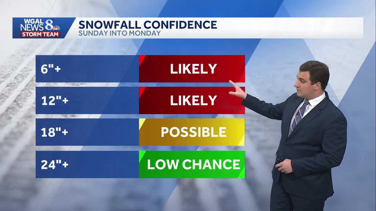
AS EXPECTED, THE APP WILL ROLL OUT IN THE COMING DAYS. NOW, THE WGAL NEWS EIGHT STORM TEAM FORECAST, WITH METEOROLOGIST MIKE SUSKO. GOOD AFTERNOON. THIS WEEK IT’S GOING TO TURN MILDER AS WE SEE HIGHS IN THE LOW 40S AS WE GO INTO TOMORROW. THEN OUR ATTENTION TURNS TO THE WEEKEND. SUNDAY IS AN ALERT DAY BECAUSE SIGNIFICANT SNOW IS MORE LIKELY. THE MODELS ARE STARTING TO COME TOGETHER, AND OUR CHANCES OF SEEING A FOOT OR MORE SNOW SOMEWHERE IN THE SUSQUEHANNA VALLEY IS INCREASING ACROSS THE AREA, SO YOU WANT TO MAKE SURE YOU’RE STARTING TO MAKE PLANS WITH THAT. HERE, LET’S TAKE A LOOK AT THE WEEKEND FORECAST HERE. SO THIS IS WHAT THE SETUP IS. HIGH PRESSURE WILL MOVE IN OVERHEAD. WE’RE STILL WATCHING TO SEE HOW STRONG THAT HIGH IS BECAUSE THAT’S GOING TO PLAY A MAJOR ROLE IN THE EXACT TRACK OF THIS SYSTEM. BUT IT DOES LOOK LIKE WE HAVE A LOW THAT WILL BE DEVELOPING OFF THE COAST OF VIRGINIA AND NORTH CAROLINAS, AND THAT WILL BE ENOUGH TO BRING COLD AIR IN WITH MULTIPLE HOURS OF PERIODS OF SNOW ACROSS THE AREA HERE. LOOKS LIKE THIS WILL BEGIN AS WE GO INTO SUNDAY EARLY MORNING AND CONTINUE THROUGHOUT. SUNDAY IS ALL DAY, SO SUNDAY ITSELF. YOU WANT TO BE PLANNING TO STAY INSIDE. AS WE GO INTO MONDAY, WE MAY SEE SOME SNOW ON THE BACKSIDE EARLY MONDAY MORNING, BUT THINGS SHOULD BEGIN TO WIND DOWN AS WE HEAD INTO MONDAY AFTERNOON. HERE’S A LOOK AT THE SNOWFALL CONFIDENCE RIGHT NOW. WE DO EXPECT THERE TO BE AT LEAST SIX INCHES OR MORE IN PARTS OF THE AREA. EVEN A FOOT OF SNOW AT THIS POINT IS BECOMING VERY LIKELY IN PARTS OF THE SUSQUEHANNA VALLEY. I KNOW SOME PHONE APPS ARE SHOWING 18IN OR MORE. IT IS A POSSIBILITY. HOWEVER, WE’RE STILL SEEING A WIDESPREAD IN THE MODELING. WE KIND OF WANT TO SEE IT COME CLOSER TOGETHER BEFORE WE REALLY SAY YES. THAT’S A DEFINITE BECAUSE THERE COULD BE A COUPLE CHANGES WITH THAT. AND TWO FEET OR MORE IS A LOW CHANCE. HERE’S ANOTHER WAY TO REPRESENT THIS HERE A FOOT OR MORE SNOW. GENERALLY AROUND 60 TO 80% CHANCE ACROSS THE SUSQUEHANNA VALLEY. BUT NOTICE THE CHANCE IS HIGHER THE FARTHER SOUTH YOU GO. SO I DO EXPECT IT TO BE GREATER. SNOW TOTALS ACROSS THE SOUTHERN PARTS OF OUR AREA COMPARED TO NORTHERN AREAS NORTH OF THE PENNSYLVANIA TURNPIKE. BUT WE ARE GOING TO BE SEEING SNOW THAT IS GOING TO BE SIGNIFICANT ACROSS THE AREA AS WE HEAD INTO SUNDAY. SO WHAT YOU CAN EXPECT IS THAT ARCTIC AIR TO BE IN PLACE WITH PRECIPITATION. MOST LIKELY IT ALL SNOW FOR THE ENTIRE EVENT. IT STARTS SUNDAY, ENDING MONDAY MORNING HERE. AND THEN AGAIN SIGNIFICANT SNOW LIKELY, WHICH IS 12IN OR MORE EXPECTED. WE DO ANTICIPATE THIS SNOW TO BE MAINLY LIGHT AND FLUFFY, SO IT’S NOT GOING TO BE THAT HEAVY, WET SNOW THAT YOU CAN SOMETIMES GET. THE TEMPERATURES SHOULD BE COLD ENOUGH WHERE WE DON’T HAVE REALLY THAT PROBLEM HERE. AND AGAIN THIS IS GOING TO BE ON SUNDAY. SO ANYTHING THAT YOU HAVE PLANNED ON SUNDAY TRY TO MOVE IT TO SATURDAY IF YOU CAN, TO BE ON THE SAFE SIDE HERE AS BECAUSE THE SNOW AGAIN WILL BE THROUGHOUT THE DAY FOR THE SECOND HALF OF THE WEEKEND. LANCASTER. RIGHT NOW THOUGH, ENJOY THE SUNSHINE WHILE YOU CAN. A NICE BEAUTIFUL WINTRY SCENE THERE. IT FEELS LIKE WINTER. WE’RE IN THE 20S RIGHT NOW, 20 IN LANCASTER, 25, IN CARLISLE, 32, IN YORK. THE FORECAST FOR THE REST OF THE DAY TODAY, GETTING UP TO AROUND 34 WITH A MIX OF SUN AND CLOUDS. TONIGHT IT DROPS DOWN TO 28 TO 32. MAY SEE A STRAY SNOW SHOWER FOR OUR WESTERN COUNTIES, BUT MOST OF US ARE GOING TO STAY DRY TOMORROW. PARTLY SUNNY WITH TEMPERATURES GETTING INTO THE LOW 40S HERE. AND WHEN WE LOOK AT THE TEN DAY FORECAST, YOU CAN SEE THURSDAY IS REALLY THE NICEST DAY WE GOT BECAUSE TEMPERATURES DROP ON FRIDAY TO AROUND 34. THE ARCTIC AIR COMES IN SATURDAY, AND AGAIN THERE’S THE ALERT DAY FOR SUNDAY WITH THAT SNOW FOR MOST, IF NOT THE ENTIRE DAY. AND SOME OF THAT LINGERING INTO MONDAY MORNING HERE AS WE
Milder Thursday; Significant Winter Storm Expected This Weekend In South Central Pennsylvania
High temperatures will reach the low 30s today with highs in the low 40s on Thursday. Significant snowfall is expected Sunday across the Susquehanna Valley.

Updated: 12:26 PM EST Jan 21, 2026
Good afternoon,Look for increasing clouds this afternoon and highs around 34 degrees. It will turn breezy again as a warm front moves north. A few flurries or a snow shower is possible this evening, mainly north and west of Harrisburg.Tonight, lows will hold steady around 30 degrees. Much warmer than this morning! A stray snow shower is possible.A weak cold front will pass early Thursday, with the slim chance of a snow shower. Otherwise, we’ll get a break in the cold, as highs climb to 42 degrees under partly sunny skies.Another arctic airmass will move into the Susquehanna Valley on Friday, knocking highs down to 34 degrees. Winds will increase to 15-25 mph in the afternoon, making it feel like the 20s.Highs will reach 18 degrees on Saturday and Sunday. We’re watching a large winter storm, which will pass through the Mid-Atlantic late Saturday night through Monday morning. At this time, Pennsylvania is in a good position for plowable snowfall and possible high snow totals. We’ll have a better idea of track, timing, and impacts today and Thursday. Snow totals will come into view on Friday morning, so please stay tuned!Early next week, highs will remain in the low 20s, along with blustery winds and frigid overnight lows in the single digits to low teens. Wind chills will have to be monitored, as they could be near or below zero at times.Arctic air remains entrenched over the area through the end of next week.Have a great day!
Good afternoon,
Look for increasing clouds this afternoon and highs around 34 degrees. It will turn breezy again as a warm front moves north. A few flurries or a snow shower is possible this evening, mainly north and west of Harrisburg.
Tonight, lows will hold steady around 30 degrees. Much warmer than this morning! A stray snow shower is possible.
A weak cold front will pass early Thursday, with the slim chance of a snow shower. Otherwise, we’ll get a break in the cold, as highs climb to 42 degrees under partly sunny skies.
Another arctic airmass will move into the Susquehanna Valley on Friday, knocking highs down to 34 degrees. Winds will increase to 15-25 mph in the afternoon, making it feel like the 20s.
Highs will reach 18 degrees on Saturday and Sunday. We’re watching a large winter storm, which will pass through the Mid-Atlantic late Saturday night through Monday morning. At this time, Pennsylvania is in a good position for plowable snowfall and possible high snow totals. We’ll have a better idea of track, timing, and impacts today and Thursday. Snow totals will come into view on Friday morning, so please stay tuned!
Early next week, highs will remain in the low 20s, along with blustery winds and frigid overnight lows in the single digits to low teens. Wind chills will have to be monitored, as they could be near or below zero at times.
Arctic air remains entrenched over the area through the end of next week.
Have a great day!