
Hour-by-hour snow projections for south-central Pennsylvania
I’M BRIAN ROCHE ON YOUR SIDE. WGAL NEWS EIGHT. NOW THE WGAL NEWS EIGHT STORM TEAM FORECAST WITH METEOROLOGIST ETHAN HUSTON GOT SOME SCATTERED SNOW SHOWERS OUTSIDE RIGHT NOW ACROSS THE SUSQUEHANNA VALLEY. BEST CHANCE FOR THOSE WILL BE NORTH AND NORTHWEST OF HARRISBURG, NORTHWEST OF I-81, BUT COULD PUT DOWN A LIGHT COATING MAKING TRAVEL SLIPPERY FOR NORTHWESTERN COMMUNITIES. CONFIDENCE IS INCREASING. WE’RE GOING TO SEE A SIGNIFICANT SNOWSTORM ON SUNDAY, AND IT IS POSSIBLE SOME AREAS OF THE VALLEY COULD AT LEAST PICK UP A FOOT. WE’LL TALK ABOUT THAT. AND THEN AS THE STORM PULLS AWAY, AN INTENSE, PROLONGED ARCTIC CHILL WILL BE AROUND. WE’RE TALKING AT LEAST A WEEK. TEMPERATURES MAY NOT GET ABOVE FREEZING. SO HERE’S THE LATEST INFORMATION ON THE SUNDAY SNOWSTORM. IT’S LIKELY GOING TO BE AROUND THROUGHOUT THE ENTIRE DAY. STARTS OFF WAY BEFORE DAWN EARLY SUNDAY MORNING AND THEN ENDS MONDAY MORNING. AGAIN, SIGNIFICANT SNOWFALLS ON THE TABLE. AND I THINK SOME OF THESE SNOWFALL RATES COULD BE IN EXCESS OF AN INCH PER HOUR. SO THAT’S GOING TO CREATE HAZARDOUS TRAVEL AS WE GO THROUGH THE DAY. WITH FRIGID TEMPERATURES IN PLACE. THAT MEANS WE’RE TALKING A LIGHT AND FLUFFY SNOW FOR MUCH OF THE VALLEY. AND MUCH OF THE AREA COULD SEE BLOWING AND DRIFTING SNOW AS THE STORM PULLS AWAY SUNDAY NIGHT INTO MONDAY. OUTSIDE RIGHT NOW, MUCH OF THE VALLEY IS DRY, BUT WE ARE STARTING TO SEE THE SNOW REACH THE GROUND AND ACCUMULATE IN OUR NORTHWESTERN COMMUNITIES. SO RIGHT ALONG THE ROUTE THREE, 22 AND 22 CORRIDOR, WE DO HAVE SOME SNOW REACHING THE GROUND, SO COATING PARTS OF THE ROADWAYS NORTH OF LEWISTOWN AND MIFFLIN COUNTY. THAT COULD ALSO BE THE CASE RIGHT NOW IN PARTS OF JUNIATA AND PERRY COUNTY. WE’LL KEEP THE CHANCES FOR SOME SPOTTY SNOW SHOWERS, PRIMARILY NORTHWEST OF HARRISBURG, DURING THE NEXT COUPLE OF HOURS. WE SHOULD START TO SEE OUR WEATHER QUIETING DOWN AS WE GET CLOSER TO MIDNIGHT, AND THEN ISOLATED SNOW SHOWERS. NOT OUT OF THE QUESTION, BUT LOW CHANCES THROUGH THE NIGHT TONIGHT AND ALSO ON INTO THURSDAY. SO NOTICE HERE ON THE PREDICTOR THAT HEAVIER BAND OF SNOW THAT’S OFF TO OUR WEST STARTS FALLING APART AROUND 11:00. COLD FRONT MOVES ON BY OUT AHEAD OF ANOTHER COLD FRONT ON THURSDAY MORNING. ISOLATED SNOW SHOWERS. NOT OUT OF THE QUESTION, BUT CHANCES ARE QUITE LOW. IN FACT, THAT FRONT FALLS APART AND WE’LL GET A LITTLE BIT MORE SUNSHINE AT TIMES AND TEMPERATURES WILL BE MILDER THAN TODAY. IT’S STILL GOING TO BE BREEZY OUT THERE AND TEMPERATURES BACK INTO THE 40S. WE’RE DRY FOR YOUR FRIDAY AND THEN THAT ARCTIC AIR STARTS MOVING ON IN AHEAD OF THE STORMS FOR THE START OF THE WEEKEND. IT’S VERY LATE SATURDAY NIGHT. THAT’S WHEN WE COULD SEE THE SNOW START MOVING IN ACROSS THE VALLEY. 32 RIGHT NOW, IF YOU’RE WATCHING US IN LEBANON, CURRENTLY 35, IN DOVER, THERE’S THE ARCTIC CHILL BUILDING ACROSS THE NORTHERN TIER OF THE COUNTRY, ACROSS THE DAKOTAS. IT’S JUST SEVEN RIGHT NOW IN MINOT. WHERE’S THE STORM RIGHT NOW? OFF THE COAST OF CALIFORNIA. WE’RE GOING TO START GETTING MORE DATA INGESTED INTO OUR WEATHER MODELING AS IT MOVES INLAND, AND THAT WILL INCREASE THE CONFIDENCE OF WHAT WE’RE GOING TO SEE FOR YOUR SUNDAY. WHAT’S STEERING THE STORM? THIS RIDGE OF HIGH PRESSURE THAT’S BUILDING OVER THE PACIFIC NORTHWEST. AND THERE’S THAT FRIGID AIR THAT’S GOING TO BE IN PLACE WHEN THE STORM STARTS TO ARRIVE. SO LET’S TALK ABOUT THE TIMING OF THIS STORM. HERE’S THAT RIDGE OF HIGH PRESSURE STORM OFF DOWN TO THE SOUTHWEST. AND NOTICE THAT LEADING EDGE OF THAT SNOW STARTS MOVING IN IN THE PRE-DAWN HOURS OF SUNDAY MORNING. AND THEN IT COULD PICK UP IN INTENSITY. AND IT’S LOOKING MORE LIKELY THAT IT’S GOING TO DO THAT AS WE GO INTO SUNDAY MORNING INTO SUNDAY AFTERNOON. AGAIN, POSSIBLY RATES OF AN INCH PER HOUR, IF NOT A LITTLE BIT HIGHER, AND THEN THE STORM PULLS AWAY ON INTO SUNDAY NIGHT. BUT IN THE STORM’S WAKE, BLUSTERY CONDITIONS WILL BE AROUND, BLOWING AND DRIFTING SNOW WILL BE POSSIBLE AS THAT RIDGE OF HIGH PRESSURE BUILDS ON IN AND TEMPERATURES STAY VERY COLD. NOW, HOW MUCH SNOW? CONFIDENCE LOOKS VERY HIGH. THIS IS GOING TO BE AT LEAST A HALF FOOT, OR WE’RE STARTING TO SEE SOME INDICATIONS THAT IT’S LIKELY SOME AREAS OF THE VALLEY COULD PICK UP AT LEAST A FOOT LOWER CONFIDENCE AS YOU GET MORE THAN THAT AGAIN, ONCE YOU GET ABOVE 18IN WITH THE SNOW STORM, YOU’RE TALKING A FREQUENCY OF MAYBE 30 TIMES IN RECORDED HISTORY THAT’S HAPPENED ACROSS THE SUSQUEHANNA VALLEY. SO WHO HAS THE BEST CHANCE FOR SEEING POSSIBLY A FOOT? SOUTHERN PORTIONS OF THE SUSQUEHANNA VALLEY, BUT A 60 TO 80% CHANCE THAT SOME AREAS ARE SEEING AT LEAST A FOOT. AND IT’S BEEN A WHILE SINCE WE’VE HAD THIS MUCH SNOW. GOT TO GO BACK TO 2021, WHEN WE SAW A STORM OF THIS STRENGTH. SO ROAD SNOW COVERED, HIGH TRAVEL IMPACTS, VISIBILITY, POOR TIMES AND SOME POWER OUTAGES WILL BE POSSIBLE. BUT THE TRACK OF THE STORM IS KEY. WE’VE SEEN THAT NORTHERN TREND, SO WE WILL CONTINUE TO SEE SOME CHANGES IN WHAT WE’RE ANTICIPATING. TEMPERATURES ARE KEY. THAT’S ALSO UP NEAR CLOUD LEVEL. IF WE SEE SOME MILDER AIR, THERE COULD BE SOME MELTING WITH THIS OR THE SNOW COULD CHANGE IN STYLE, COULD BE A HEAVIER, WETTER SNOW. AND HOW LONG THE STORM STICKS AROUND. THAT COULD BE AN INDICATION OF JUST HOW MUCH SNOW WE SEE. SO FORECAST IS NOT SET IN STONE, BUT BE PREPARED FOR A POWERFUL, DISRUPTIVE SNOWSTORM THROUGH THE DAY ON SUNDAY, ON INTO MONDAY, THERE’S THAT INTENSE CHILL THAT FOLLOWS THE SNOWSTORM. NOTICE THE SERIES OF DAYS AT OR
Hour-by-hour snow projections for south-central Pennsylvania

Updated: 8:07 PM EST Jan 21, 2026
A significant winter storm will impact South-Central Pennsylvania starting Sunday, with most areas likely to see more than six inches of snow and many locations expecting a foot or more.WGAL Meteorologist Ethan Huston has the latest hour-by-hour snow timeline in the video player above. Snow timingSnow develops in the predawn hours of Sunday morning.Snow intensifies Sunday afternoon and Sunday evening — this is when the heaviest snow is likely.The coastal low pulls away by Monday morning, but additional snow on the backside is possible into Monday. In the storm’s wake, blustery conditions will be blowing and drifting snow around. Expected snowfallAbout a 24-hour event is likely.6 inches or more: very likely across the region.12 inches: currently looking likely for much of the area.18 inches (1.5 ft): possible but probability is decreasing.12–24 inches or 2 feet+: low probability for South-Central Pennsylvania at this time.Some guidance shows a 60–80% chance of at least a foot across much of the area, tapering off to the north.Why this storm could be potentHigh pressure to the west will lock in Arctic air, favoring heavy, cold snow.Storm track will control intensity and precipitation type; small shifts can change totals and whether any mixing occurs.Longer duration of snowfall will drive higher totals.Impacts and hazardsSnow-covered roads and high travel impacts expected — visibility could be poor at times.Breezy conditions into Monday may reduce visibility further and raise the risk of post-storm power outages.Temperatures and minor track changes could alter precipitation type and melting during the event.Bottom lineMonitor forecast updates; heavy snow Sunday into Monday will create hazardous travel and potential service impacts across South-Central Pennsylvania.SOUTH-CENTRAL PA WEATHER RESOURCES: INTERACTIVE RADAR | ACTIVE WEATHER ALERTS | CURRENT CONDITIONS | HOURLY FORECAST | 10-DAY FORECAST | WEEKEND FORECAST | MAP ROOM | DOWNLOAD THE APP | WEATHER EMAILS
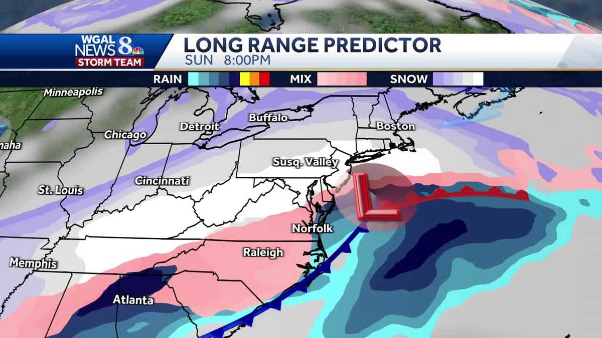
A significant winter storm will impact South-Central Pennsylvania starting Sunday, with most areas likely to see more than six inches of snow and many locations expecting a foot or more.
WGAL Meteorologist Ethan Huston has the latest hour-by-hour snow timeline in the video player above.
Snow timingSnow develops in the predawn hours of Sunday morning.Snow intensifies Sunday afternoon and Sunday evening — this is when the heaviest snow is likely.The coastal low pulls away by Monday morning, but additional snow on the backside is possible into Monday. In the storm’s wake, blustery conditions will be blowing and drifting snow around.


Expected snowfallAbout a 24-hour event is likely.6 inches or more: very likely across the region.12 inches: currently looking likely for much of the area.18 inches (1.5 ft): possible but probability is decreasing.12–24 inches or 2 feet+: low probability for South-Central Pennsylvania at this time.Some guidance shows a 60–80% chance of at least a foot across much of the area, tapering off to the north.


Why this storm could be potentHigh pressure to the west will lock in Arctic air, favoring heavy, cold snow.Storm track will control intensity and precipitation type; small shifts can change totals and whether any mixing occurs.Longer duration of snowfall will drive higher totals.Impacts and hazardsSnow-covered roads and high travel impacts expected — visibility could be poor at times.Breezy conditions into Monday may reduce visibility further and raise the risk of post-storm power outages.Temperatures and minor track changes could alter precipitation type and melting during the event.

Bottom lineMonitor forecast updates; heavy snow Sunday into Monday will create hazardous travel and potential service impacts across South-Central Pennsylvania.
SOUTH-CENTRAL PA WEATHER RESOURCES: INTERACTIVE RADAR | ACTIVE WEATHER ALERTS | CURRENT CONDITIONS | HOURLY FORECAST | 10-DAY FORECAST | WEEKEND FORECAST | MAP ROOM | DOWNLOAD THE APP | WEATHER EMAILS