
Weekend winter storm in Western Pennsylvania | Up to a foot of snow
PITTSBURGH’S ACTION SPORTS. I’LL TELL YOU WHAT THE WEATHER GODS MUST HAVE DISRESPECTED THE TERRIBLE TOWEL BECAUSE I THINK WE’RE GOING TO PAY THE PRICE THIS WEEKEND. I KNOW JUST ABOUT EVERYBODY ACROSS THE COUNTRY DEALING WITH THESE COLD TEMPERATURES, AND THIS STORM IS MASSIVE, TOO, SO. WELL, WE’RE OF COURSE DEALING WITH THE IMPACTS. IT’S GOING TO BE REALLY A GOOD PORTION OF THE COUNTRY SEEING SOME SIGNIFICANT SNOW COMING OUT OF THIS STORM. BUT BEFORE WE GET THERE, WE’VE GOT TO TALK ABOUT THE EXTREME COLD HERE THIS MORNING. WIND CHILLS ALREADY DOWN DOUBLE DIGITS BELOW ZERO. NOT EXPECTING MUCH IMPROVEMENT AS WE GO THROUGHOUT THE DAY. WHEN WILL THE SNOW BEGIN? WELL, FOR MOST OF US WILL BE CLOSER TO MIDNIGHT. SO DURING THE DAY OUTSIDE THE COLD THINGS ARE GOING TO BE DRY AND JUST FINE. BUT OF COURSE, TOMORROW A WHOLE DIFFERENT BALLGAME AS SNOW IS GOING TO BE HEAVY AT TIMES. STILL CONCERNED ABOUT SOME OF THAT WINTRY MIX THAT COULD BE CREEPING IN FROM THE SOUTH. WELL, PINPOINT THAT WITH FUTURECAST HERE IN JUST A MOMENT, AND EVENTUALLY ALL THE SNOW WILL BE WRAPPING UP ON MONDAY. BUT AS YOU CAN SEE, THREE ALERT DAYS IN A ROW NOW FEELS LIKE TEN BELOW RIGHT NOW IN PITTSBURGH. ALSO FOR WASHINGTON. RIGHT AROUND THAT MARK FOR FRANKLIN. MEANWHILE, IT’S 13 BELOW FOR YOUR CURRENT FEELS-LIKE TEMPERATURE IN UNIONTOWN FEELS LIKE ONE BELOW IN BEAVER. POSITIVE SIDE OF THINGS. WE CHECK INTO KITTANNING HERE THIS MORNING, BUT SIMPLY PUT, EVERYBODY IS BITTERLY COLD AND IT’S GOING TO STAY THAT WAY AS WE GO THROUGH THIS ALERT DAY. HERE’S 10:00 THIS MORNING. STILL, A NUMBER OF NEIGHBORHOODS FEELING SUBZERO AS WE HEAD INTO THE AFTERNOON. NOT MUCH IMPROVEMENT AS WIND CHILLS WILL STAY CLOSE TO ZERO BASICALLY ALL DAY LONG FOR THIS DAY BEFORE THE WINTER STORMS. SPEAKING OF THE WINTER STORM, WINTER STORM WARNING GOES INTO EFFECT AT 7:00 TONIGHT. WE’LL TAKE US THROUGH 1 P.M. ON MONDAY. THAT’S EVERYBODY ACROSS WESTERN PENNSYLVANIA, AS WE WILL ALL TAP INTO THIS SNOW. WANT TO REALLY HONE IN ON THE TIME LINE OF THESE ACCUMULATIONS FROM LATE TONIGHT THROUGH THE END OF THE DAY TOMORROW. STILL TALKING ABOUT AN AREA WIDE 8 TO 12IN OF SNOW. THAT WINTRY MIX COULD DROP SOME OF THOSE TOTALS DOWN THROUGH PARTS OF WESTMORELAND, FAYETTE COUNTY’S NORTHERN WEST VIRGINIA AS WELL, BUT STILL TALKING ABOUT DOUBLE DIGITS OF SNOW IN MOST NEIGHBORHOODS. AND STILL WE COULD TACK ON SOME ADDITIONAL ACCUMULATIONS MONDAY MORNING AS WELL. WE’RE GOING TO SPEED AHEAD THROUGH THE DAY TODAY. AGAIN, ALL IS QUIET UNTIL WE ROLL CLOSER TO THE MIDNIGHT HOUR. WE WILL SEE SOME STEADY SNOW STARTING TO LIFT IN FROM THE SOUTH BECOMES AREA WIDE VERY QUICKLY WHILE YOU’RE SLEEPING LATE TONIGHT, EVEN SOME OF THAT HEAVY SNOW COULD BE KICKING IN AS EARLY AS 6 A.M. TOMORROW. KEEP AN EYE ON THAT DARKER SHADE OF THAT BLUE PURPLE ALREADY STARTING TO MOVE INTO NEIGHBORHOODS ACROSS ALLEGHENY COUNTY. BY 6 A.M. SEVERAL HOURS, THE HEAVY SNOW IT COULD PUT DOWN AN INCH OR TWO PER HOUR. THEN WE GET A LITTLE CONCERNED ABOUT THIS WARM NOSE THAT CONTINUES TO COME IN. WE’VE BEEN TALKING ABOUT THAT FOR SEVERAL DAYS NOW. ONE OF THE BIG QUESTION MARKS WITH THIS STORM STILL LOOKS TO REACH SOME AREAS INTO WESTMORELAND, CERTAINLY FAYETTE COUNTY, EVEN BACK THROUGH NORTHERN WEST VIRGINIA. SO SOME OF THAT SLEET AND FREEZING RAIN WILL STILL PILE UP, BUT IT WILL COMPACT SOME. THE SNOW THAT IS ALREADY ON THE GROUND, EVEN MAKING IT MORE DIFFICULT FOR YOU TO MOVE THAT SNOW AS THAT WARM NOSE BUILDS IN. WE’RE ALSO GOING TO SEE THE CHANGE IN THE NATURE OF THE SNOWFLAKES IN AND AROUND PITTSBURGH, EVEN POINTS FARTHER TOWARDS THE NORTH. BECOME MORE OF THAT PASTY, HEAVY, WET SNOW FOR AT LEAST A PERIOD OF TIME. SO THAT REALLY COULD WEIGH THINGS DOWN AS WE GO THROUGH THE AFTERNOON HOURS. THEN WE MAKE THAT CHANGE BACK OVER TO SNOW AROUND DINNERTIME SUNDAY. STILL TALK ABOUT SOME STEADY BURSTS OF SNOW THROUGH ABOUT THE MIDNIGHT HOUR. THINGS WILL BE TAPERING OFF MONDAY BEFORE EVENTUALLY THINGS WILL BE WRAPPING UP TOWARDS MIDDAY. WE WILL SEE THAT WINTER STORM WARNING EXPIRE. OVER TO YOUR 4-DAY PLUS 4 MORE FORECAST AGAIN. THREE IMPACT DAYS IN A ROW. THAT ADDITIONAL SNOW ON MONDAY COULD BE ANYWHERE FROM 1 TO 3IN. SO AGAIN, THAT REALLY IS PILING UP OUR TOTALS. COULD WE TALK ABOUT MORE THAN A FOOT IN SEVERAL NEIGHBORHOODS? ONCE THE STORM IS ALL SAID AND DONE ON MONDAY, STILL, TEMPERATURES ARE GOING TO BE VERY COLD AS EVERYBODY IS OUT TRYING TO CLEAR THE SNOW. AND REALLY NO BREAK FROM THAT BITING COLD INTO NEXT WEEK. I’VE ADDED AN IMPACT DAY TO TUESDAY, BUT MORE THAN LIKELY WE’LL NEED TO UPGRADE THIS TO AN ALERT DAY FOR MORE EXTREME COLD, ESPECIALLY INTO THE MORNINGS MORNING HOURS, AS WIND CHILLS COULD BE ANYWHERE FROM 30 TO EVEN 20 DEGREES BELOW ZERO. NOT EXPECTING MUCH IMPROVEMENT. AS WE GO THROUGH THE UPCOMING WEEK. SO YOUR FURNACE IS REALLY GOING TO BE WORKING OVERTIME HERE AS LOWS ARE GOING TO START AROUND ZERO. AFTERNOON TEMPERATURES ONLY IN THE TEENS, MAYBE PUSHING 20 AS WE HEAD TOWARDS THIS TIME NEXT WEEK. SO IT IS GOING TO BE A LONG, COLD STRETCH HERE IN WESTERN PENNSYLVANIA. AND OF COURSE THAT FRESH SNOW NOT REALLY HELPING US OUT AS WELL. I DON’T HAVE ANYTHING TO SAY. BRUTAL, BRUTAL BY ALL REGARDS, ESPECIALLY FOR JANUARY. BUT THIS SEEMS THIS SEEMS AGGRESSIVE. IT IS. IT’S A LOT. AND WE JUST GOT TO GET THROUGH IT TOGETHER. I KNOW THAT’S EASIER SAID THAN DONE, BUT WE WILL MAKE IT THROUGH. ABSOLUTELY. THAT’S A GREAT REMINDER TO CHECK ON YOUR NEIGHBORS, YOUR LOVED ONES, MAKE SURE EVERYONE IS GOOD TO GO. TH
Weekend winter storm in Western Pennsylvania | Up to a foot of snow

Updated: 7:35 AM EST Jan 24, 2026
Extreme cold will be followed by a major snowstorm as a blast of winter weather hits Western Pennsylvania this weekend.Watch the latest forecast from Pittsburgh’s Action Weather in the video aboveA winter storm warning goes into effect Saturday evening. We are expecting around 8 to 12 inches of snow by the end of Sunday, with higher amounts of 10 or more inches possible into the Laurel Highlands along the I-68 corridor, according to the latest forecast from Pittsburgh’s Action Weather. There could be an additional 1 to 3 inches of snow through Monday morning.Stay with WTAE.com and the WTAE app for breaking news updates.More: See current weather alerts for your countyInteractive radar: Track snow moving through your areaLearn how to enable automatic weather alerts on the WTAE appWinter Storm WarningThe National Weather Service has issued a winter storm warning for the entire region, starting at 7 p.m. Saturday and continuing through noon Monday. Alert Day for extreme cold Saturday is a Severe Weather Alert Day with another round of brutal cold. Wake-up temperatures will be near 0° with wind chills between -10° and -20° for most of Western Pennsylvania. Temperatures and wind chills will barely improve as we head through the day. A cold weather advisory has been issued for Saturday morning.Conditions will remain quiet and dry for last-minute trips to the store before the snow arrives Saturday night.Winter storm warning: Significant snow on SundaySunday is also a Severe Weather Alert Day for snow. The storm will approach from the south with the snow starting Saturday night.Models are in agreement that the brunt of the storm will be during the day on Sunday. Snow could pile up at rates of 1 to 2 inches per hour.The heaviest snow will taper off Sunday evening, and the storm will finally end Monday morning.Significant snow is anticipated across the Pittsburgh region. The forecast holds with 8 to 12 inches of snow to fall by the end of Sunday for most of Western Pennsylvania. We could tack on an additional one to three inches through Monday morning.The question remains whether enough warm air will make it north into our area to allow for a period of sleet and/or freezing rain south of Interstate 70 and into the Laurel Highlands. If it does, this will limit snow totals here but add icing concerns.SATURDAY – Severe Weather Alert Day: Dangerous cold with sub-zero wind chills. High: 14.SATURDAY NIGHT – Severe Weather Alert Day: Snow arrives after midnight. Low: 10.SUNDAY – Severe Weather Alert Day: A significant amount of snow. High: 24, low: 14.MONDAY – Severe Weather Alert Day: Morning snow, then cold. High: 18, low: 0.
PITTSBURGH —
Extreme cold will be followed by a major snowstorm as a blast of winter weather hits Western Pennsylvania this weekend.
Watch the latest forecast from Pittsburgh’s Action Weather in the video above
A winter storm warning goes into effect Saturday evening. We are expecting around 8 to 12 inches of snow by the end of Sunday, with higher amounts of 10 or more inches possible into the Laurel Highlands along the I-68 corridor, according to the latest forecast from Pittsburgh’s Action Weather.
There could be an additional 1 to 3 inches of snow through Monday morning.
Stay with WTAE.com and the WTAE app for breaking news updates.
Winter Storm Warning
The National Weather Service has issued a winter storm warning for the entire region, starting at 7 p.m. Saturday and continuing through noon Monday.

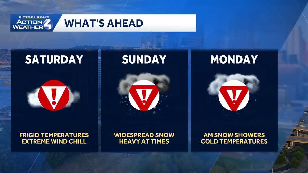
Alert Day for extreme cold
Saturday is a Severe Weather Alert Day with another round of brutal cold. Wake-up temperatures will be near 0° with wind chills between -10° and -20° for most of Western Pennsylvania. Temperatures and wind chills will barely improve as we head through the day. A cold weather advisory has been issued for Saturday morning.

Conditions will remain quiet and dry for last-minute trips to the store before the snow arrives Saturday night.
Winter storm warning: Significant snow on Sunday
Sunday is also a Severe Weather Alert Day for snow. The storm will approach from the south with the snow starting Saturday night.
Models are in agreement that the brunt of the storm will be during the day on Sunday. Snow could pile up at rates of 1 to 2 inches per hour.
The heaviest snow will taper off Sunday evening, and the storm will finally end Monday morning.
Significant snow is anticipated across the Pittsburgh region. The forecast holds with 8 to 12 inches of snow to fall by the end of Sunday for most of Western Pennsylvania. We could tack on an additional one to three inches through Monday morning.

The question remains whether enough warm air will make it north into our area to allow for a period of sleet and/or freezing rain south of Interstate 70 and into the Laurel Highlands. If it does, this will limit snow totals here but add icing concerns.
SATURDAY – Severe Weather Alert Day: Dangerous cold with sub-zero wind chills. High: 14.
SATURDAY NIGHT – Severe Weather Alert Day: Snow arrives after midnight. Low: 10.
SUNDAY – Severe Weather Alert Day: A significant amount of snow. High: 24, low: 14.
MONDAY – Severe Weather Alert Day: Morning snow, then cold. High: 18, low: 0.
