
GOOD MORNING. IT IS AN ALERT DAY. SNOW HAS BEEN FALLING FOR HOURS NOW. IN SOME SPOTS, YOU ALREADY HAVE AN INCH OR TWO ON THE GROUND, SO THAT WILL CONTINUE THIS MORNING. YOU SEE WIDESPREAD SNOW. IT COULD BECOME HEAVY AT TIMES. WE’RE TALKING SNOWFALL RATES OF 1 TO 2IN PER HOUR LATE MORNING INTO THE AFTERNOON. AND WE’RE GOING TO BE REALLY WATCHING THAT LINE OF SLEET. HOW FAR NORTH DOES IT COME AND HOW DOES THAT IMPACT OUR TOTALS? SO I AM THINKING THAT ESPECIALLY ADAMS, YORK AND LANCASTER COUNTIES, YOU WILL SEE UP TO A FOOT OF SNOW, BUT YOU COULD ALSO GET A COUPLE OF INCHES OF SLEET, PROVIDED THIS LINE GETS AS FAR NORTH AS WE THINK IT WILL. MOST OF THE SUSQUEHANNA VALLEY, THOUGH. 12 TO 18IN OF SNOW. SO THIS IS GOING TO BE OUR BIGGEST STORM IN FIVE YEARS FOR THE MORNING. EVERYBODY SEES SNOW IN THE AFTERNOON. IT’S SNOW AND SOME SLEET. SOUTHEAST EVENING STILL SNOW AND SOME SLEET SOUTHEAST. AND THE WHOLE STORM STARTS TO WIND DOWN AS WE APPROACH THE LATE EVENING. I THINK IT’S OUT OF HERE BY MIDNIGHT. THE BAD NEWS IS, IF YOU’RE OUT IN THE SNOW SHOVELING, IT IS GOING TO BE FRIGID TODAY. LOOK AT THESE TEMPERATURES. THEY’RE GOING TO STAY IN THE THIS IS THE WINDCHILL IN THE PINK. AND THAT IS DEFINITELY IN THE LOWER SINGLE DIGITS. SO VER
SNOWSTORM HITS PA: Heavy snow coats Susquehanna Valley | NEW total map

Updated: 6:31 AM EST Jan 25, 2026
Snow is falling across the Susquehanna Valley and accumulating quickly.WGAL News 8’s Storm Team is monitoring the snowstorm in real time and will continue to share the latest updates. A Winter Storm Warning, issued by the National Weather Service, is in effect until 1 p.m. on Monday. Snow TimingSnow developed after midnight and is moving south to north.Heavy snow overnight will continue into the morning and early afternoon, with peak rates during the morning. As we go into the afternoon, southern/southeastern counties will see snow mix over to sleet. This could lower snow totals.Most precipitation should taper/end late Sunday night.Totals: 1-2 inches per hour Most locations: Between 12-18 inches. Southern Lancaster, York and Adams counties: About a foot of snow, followed by a couple of inches of sleet. Sleet could reduce totals, and some models show sleet pushing north toward Harrisburg—this would lower accumulations where it occurs. Snowfall rates: 1–2 inches per hour at times. Winds, drifting snow and cold ahead Windy stretch: Blustery conditions build Sunday afternoon into evening; Northwest winds strengthen Monday with gusts of 15–25 mph.Visibility and roads: Blowing and drifting snow could reduce visibility and further worsen travel conditions.Cold blast next week: Highs in the low 20s, lows in the single digits, with wind chills likely below zero on many nights.Impacts and precautions Travel: Conditions may be hazardous and dangerous at times—avoid travel if you can.Road restrictions: PennDOT has reduced speed limits on major highways across the region. Visibility and disruptions: Heavy snow will reduce visibility; expect delays, potential road closures, and possible power outages.Be prepared: Plan for extended cold and limited mobility after the storm, and keep up with local updates.Do you have photos or videos of the snowstorm? Send them to WGAL News 8 at https://www.wgal.com/upload. Be sure to include where the image was captured. SOUTH-CENTRAL PA WEATHER RESOURCES: INTERACTIVE RADAR | ACTIVE WEATHER ALERTS | CURRENT CONDITIONS | HOURLY FORECAST | 10-DAY FORECAST | WEEKEND FORECAST | MAP ROOM | DOWNLOAD THE APP | WEATHER EMAILS
Snow is falling across the Susquehanna Valley and accumulating quickly.
WGAL News 8’s Storm Team is monitoring the snowstorm in real time and will continue to share the latest updates.
A Winter Storm Warning, issued by the National Weather Service, is in effect until 1 p.m. on Monday.


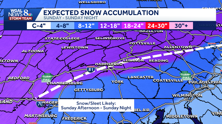
Snow Timing
Snow developed after midnight and is moving south to north.Heavy snow overnight will continue into the morning and early afternoon, with peak rates during the morning. As we go into the afternoon, southern/southeastern counties will see snow mix over to sleet. This could lower snow totals.Most precipitation should taper/end late Sunday night.


Totals: 1-2 inches per hour Most locations: Between 12-18 inches. Southern Lancaster, York and Adams counties: About a foot of snow, followed by a couple of inches of sleet. Sleet could reduce totals, and some models show sleet pushing north toward Harrisburg—this would lower accumulations where it occurs. Snowfall rates: 1–2 inches per hour at times.


Winds, drifting snow and cold ahead Windy stretch: Blustery conditions build Sunday afternoon into evening; Northwest winds strengthen Monday with gusts of 15–25 mph.Visibility and roads: Blowing and drifting snow could reduce visibility and further worsen travel conditions.Cold blast next week: Highs in the low 20s, lows in the single digits, with wind chills likely below zero on many nights.


Impacts and precautions Travel: Conditions may be hazardous and dangerous at times—avoid travel if you can.Road restrictions: PennDOT has reduced speed limits on major highways across the region. Visibility and disruptions: Heavy snow will reduce visibility; expect delays, potential road closures, and possible power outages.Be prepared: Plan for extended cold and limited mobility after the storm, and keep up with local updates.


Do you have photos or videos of the snowstorm? Send them to WGAL News 8 at https://www.wgal.com/upload. Be sure to include where the image was captured.
SOUTH-CENTRAL PA WEATHER RESOURCES: INTERACTIVE RADAR | ACTIVE WEATHER ALERTS | CURRENT CONDITIONS | HOURLY FORECAST | 10-DAY FORECAST | WEEKEND FORECAST | MAP ROOM | DOWNLOAD THE APP | WEATHER EMAILS