
Snowstorm hits Western Pennsylvania | Up to a foot of snow possible
Accumulations through Monday morning could top a foot.
OUT ALREADY THIS WINTER STORM WELL UNDERWAY AND STILL THE HEAVIEST SNOW IS STILL HOURS AWAY. MORE THAN LIKELY WE’LL SEE THAT HAPPENING BETWEEN ABOUT TEN AND FOUR TODAY. TOTAL ACCUMULATIONS. BY THE TIME THINGS ARE ALL SAID AND DONE ABOUT MIDDAY TOMORROW, ABOUT 9 TO 12IN OF SNOW ACROSS A GOOD PORTION OF THE AREA. A LITTLE BIT HIGHER AS ALREADY SOME SNOW BANDS HAVE BEEN PULLING DOWN SOME CONSIDERABLE AMOUNTS OF SNOW, ESPECIALLY NORTHERN PARTS OF ALLEGHENY COUNTY, INTO NOW BEAVER, BUTLER, POTENTIALLY EVEN INTO ARMSTRONG AND INDIANA COUNTIES. AS WE CONTINUE THROUGH THE SIGNIFICANT WINTER STORM. THE ALERT DAY IS ALSO FOR WINTRY MIX WILL BE SETTING UP CLOSER TO NOONTIME, ESPECIALLY FOR THOSE OF YOU SOUTH AND EAST OF THE CITY. I THINK AREAS AS FAR NORTH AS LATROBE, POSSIBLY EVEN INTO UNIONTOWN, BACK TOWARDS WAYNESBORO. YOU COULD SEE A LITTLE BIT OF THAT SLEET, SO YOU WILL HEAR THE DING, AND THEN THE FREEZING RAIN WILL START TO CLING TO THINGS, AND ALL THAT ICE COULD LEAD TO SOME ADDITIONAL IMPACTS, INCLUDING SOME POWER OUTAGES, ESPECIALLY AS THE SNOW CONTINUES TO PILE ON AGAIN. EVERYTHING WILL BE WRAPPING UP TOWARDS MIDDAY TOMORROW. SOME HEAVIER SNOW NOW STARTING TO BUILD IN ACROSS A GOOD PORTION OF BEAVER COUNTY THAT INCLUDES BEAVER FALLS EXTENDING DOWN TOWARDS HOPEWELL, EVEN INTO THE WESTERN PARTS OF ALLEGHENY COUNTY. RIGHT NOW. HARD TO DECIPHER THESE SHADES OF BLUE BECAUSE EVERYBODY IS SEEING A GOOD AMOUNT OF SNOW ACROSS THE REGION. THE GOOD NEWS? IF YOU WANT TO KIND OF GET A LITTLE BIT OF A HEAD START ON SHOVELING AND CLEARING THE SNOW, EVERYTHING IS VERY LIGHT AND POWDERY, SO IT WILL BE EASIER TO CLEAR A LITTLE LATER ON TODAY, THE TYPE OF SNOW WE GET WILL BE CHANGING, SO INTENSITY IS ALSO STARTING TO RAMP UP THROUGH THE MON VALLEY. EVEN AS WE SPREAD INTO WESTMORELAND COUNTY AS WELL. RIGHT NOW, SNOW IS A BIT LIGHTER IN FAYETTE COUNTY, BUT THAT ALSO WILL BE SHORT LIVED. YOU CAN SEE PLENTY OF SNOW STILL BEING PUMPED IN, AND THIS STORM SYSTEM IS STRETCHING OUT ACROSS A GOOD PORTION OF THE COUNTRY AS WE STILL HAVE A WAYS TO GO. WINTER STORM WARNING WILL TAKE US THROUGH NOON TOMORROW. THAT’S FOR EVERYBODY ACROSS WESTERN PENNSYLVANIA. SO KIND OF A BREAKDOWN OF HOW QUICKLY THE SNOW WILL BE COMING IN, EVEN THOUGH THERE’S STILL JUST SEVERAL INCHES OF SNOW ON THE GROUND RIGHT NOW. A LITTLE EASIER TO CLEAR THINGS OUT BEFORE 7:00 HERE THIS MORNING AS WE LOOK TOWARDS THE TOP OF THE HOUR. BUT AS YOU GO TOWARDS THE AFTERNOON EVENING HOURS AS WELL, THE SNOW INTENSITY WILL RAMP UP. WE’RE GOING TO SEE SEVERAL INCHES COMING IN OVER THE COURSE OF JUST A MATTER OF HOURS BEFORE THINGS START TO TAPER OFF LATER ON TONIGHT, A LITTLE BIT OF A CLOSER LOOK AT THAT SNOW FORECAST IS GOING TO TAKE US THROUGH MONDAY MORNING. 9 TO 12IN A GOOD BASE FOR MOST OF THE AREA. LOCALLY HIGHER AMOUNTS EXPECTED NORTH OF THE CITY. WE’VE ALREADY SEEN THOSE INTENSE BANDS OF SNOW WORKING THROUGH. MORE HEAVY SNOW WILL BE DEVELOPING AS WE GO THROUGHOUT THE DAY. AND AGAIN, THAT SNOW IS GOING TO GO FROM LIGHT AND POWDERY TO A LITTLE BIT HEAVIER AND WETTER. BETTER FOR PACKING. THAT ALSO COULD LEAD TO SOME RAPID ACCUMULATIONS AS WELL. AS WE WORK THROUGH THE DAY SOUTH AND EAST, THOUGH, YOUR TOTALS GET CUT BACK CLOSER TO 6 TO 9IN BECAUSE OF THAT WINTRY MIX. THAT WILL ALSO ADD SOME ICY ACCUMULATIONS. A LOOK AT FUTURECAST. YOU’RE GOING TO SEE A LOT OF SNOW THROUGHOUT THE DAY. INTENSITIES WILL BE PICKING UP FROM TIME TO TIME, SO OBVIOUSLY TRAVEL CONDITIONS WILL BE DETERIORATED NOT JUST IN THE SHAPE OF THE ROADS, BUT ALSO VISIBILITY AS WELL. KEEP AN EYE SOUTH OF I-70 AS WE GET CLOSER TO NOON TODAY. THAT WARM NOSE, THAT WARM LAYER TRYING TO BUILD IN, BRING THAT WINTRY MIX INTO SPOTS LIKE MORGANTOWN, ALSO INTO FAYETTE COUNTY, POSSIBLY, AS I MENTIONED BEFORE, AS FAR NORTH AS LATROBE. THAT WOULD BE RELATIVELY SHORT LIVED. SHOULD BE WRAPPING UP AS WE GET CLOSER TO 4:00. BUT FOR EVERYBODY ELSE, AGAIN, THAT SNOW BECOMES A LITTLE BIT PASTIER AND HEAVIER, HARDER TO MOVE AS WE GO THROUGH THE SECOND PART OF THE DAY. STILL SOME STEADY SNOW INTO 8:00 TONIGHT AND THINGS SHOULD BEGIN TO TAPER OFF AS WE APPROACH MIDNIGHT, WITH STILL SOME LINGERING SNOW CHANCES EVEN INTO TOMORROW MORNING. WE’VE GOT THREE ALERT DAYS IN A ROW. THE SNOW WILL END EVENTUALLY. TOMORROW MORNING. NOW WE SHIFT OUR FOCUS TO SUBZERO WIND CHILLS AS WE ARE EXPECTING THOSE TO STICK AROUND TUESDAY, POSSIBLY EVEN WEDNESDAY, BUT STILL
Snowstorm hits Western Pennsylvania | Up to a foot of snow possible
Accumulations through Monday morning could top a foot.

Updated: 9:37 AM EST Jan 25, 2026
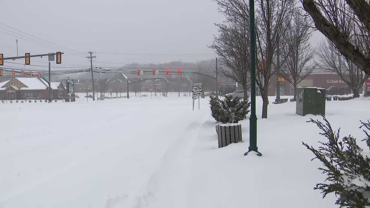
Snow is underway as a massive winter storm hits western Pennsylvania on Sunday morning.Watch the latest forecast from Pittsburgh’s Action Weather in the video aboveThe majority of the accumulation will come between 10 a.m. and 4 p.m. We are still watching a period of sleet/freezing rain for areas to the southeast of Pittsburgh.A winter storm warning is in effect for the entire area through noon Monday. Travel will be treacherous as heavy snow falls throughout the day.Stay with WTAE.com and the WTAE app for breaking news updates.More: See current weather alerts for your countyInteractive radar: Track snow moving through your areaLearn how to enable automatic weather alerts on the WTAE appAlert Day: Heavy snow for western Pennsylvania Sunday is a Severe Weather Alert Day for heavy snow. A couple of inches of snow are already on the ground. Snow could pile up at rates of one to two inches per hour. The majority of this significant accumulation will come between 10 a.m. and 4 p.m.Steady snow will taper off Sunday evening. The storm will finally end Monday morning.We are keeping a close eye on warm air moving north through West Virginia. A period of sleet and/or freezing rain is expected between late morning and this evening. The warm air will settle over areas south of Interstate 70 and into the Laurel Highlands. This will limit snow totals and add icing concerns for cities like Waynesburg, Uniontown, and possibly as far north as Latrobe.How much snow will we get?This will be Pittsburgh’s biggest snowstorm since “Snowmageddon” in 2010. The forecast calls for 9-12 inches of snow with some locations reaching 14 inches of snow. Bands of heavier snow will set up just north of Pittsburgh and up the totals. Areas that experience the wintry mix will see reduced accumulations of six to nine inches. Additional light snow is possible as the storm pulls away Monday morning. TODAY – Severe Weather Alert Day: A significant amount of snow. High: 27°.TONIGHT – Severe Weather Alert Day: Snow tapers off. Low: 14°.MONDAY – Severe Weather Alert Day: Morning snow then very cold. High: 18°, low: 0°.TUESDAY – Severe Weather Alert Day: Sub-zero wind chills in the morning, partly cloudy with stray flurries. High: 16°, low: 3°.WEDNESDAY – Impact Day: Harsh wind chills and flurries. High: 17°, low: 1°.
PITTSBURGH —
Snow is underway as a massive winter storm hits western Pennsylvania on Sunday morning.
Watch the latest forecast from Pittsburgh’s Action Weather in the video above
The majority of the accumulation will come between 10 a.m. and 4 p.m. We are still watching a period of sleet/freezing rain for areas to the southeast of Pittsburgh.
A winter storm warning is in effect for the entire area through noon Monday. Travel will be treacherous as heavy snow falls throughout the day.
Stay with WTAE.com and the WTAE app for breaking news updates.
Alert Day: Heavy snow for western Pennsylvania
Sunday is a Severe Weather Alert Day for heavy snow. A couple of inches of snow are already on the ground. Snow could pile up at rates of one to two inches per hour. The majority of this significant accumulation will come between 10 a.m. and 4 p.m.
Steady snow will taper off Sunday evening. The storm will finally end Monday morning.
We are keeping a close eye on warm air moving north through West Virginia. A period of sleet and/or freezing rain is expected between late morning and this evening. The warm air will settle over areas south of Interstate 70 and into the Laurel Highlands. This will limit snow totals and add icing concerns for cities like Waynesburg, Uniontown, and possibly as far north as Latrobe.
How much snow will we get?
This will be Pittsburgh’s biggest snowstorm since “Snowmageddon” in 2010. The forecast calls for 9-12 inches of snow with some locations reaching 14 inches of snow. Bands of heavier snow will set up just north of Pittsburgh and up the totals. Areas that experience the wintry mix will see reduced accumulations of six to nine inches.
Additional light snow is possible as the storm pulls away Monday morning.
TODAY – Severe Weather Alert Day: A significant amount of snow. High: 27°.
TONIGHT – Severe Weather Alert Day: Snow tapers off. Low: 14°.
MONDAY – Severe Weather Alert Day: Morning snow then very cold. High: 18°, low: 0°.
TUESDAY – Severe Weather Alert Day: Sub-zero wind chills in the morning, partly cloudy with stray flurries. High: 16°, low: 3°.
WEDNESDAY – Impact Day: Harsh wind chills and flurries. High: 17°, low: 1°.