
Alert Day: Ongoing heavy snow for western PA
Accumulations through Monday morning could top a foot.
KAYLA, WE DO APPRECIATE ALL OF YOUR REPORTS AND HOPEFULLY THE PEACE AND QUIET THAT YOU’RE ALSO ENJOYING THERE ON WASHINGTON ROAD IN MOUNT LEBANON. CERTAINLY NOT THE CASE DURING A USUAL DAY. AGAIN, WE’RE IN THE MIDST OF A SIGNIFICANT WINTER STORM. COULD PUT DOWN ANYWHERE FROM 9 TO 12IN OF SNOW ACROSS A GOOD PORTION OF THE AREA. ALREADY, A NUMBER OF AREAS NORTH OF THE CITY, OVER A HALF FOOT, WORKING TOWARDS TEN INCHES OF SNOW. SO VERY EASILY WE COULD BE TALKING ABOUT MORE THAN A FOOT, MAYBE PUSHING 14IN OF SNOW THROUGH PARTS OF BEAVER, LAWRENCE AND BUTLER COUNTY. STILL, THE HEAVIEST SNOW REALLY KNOCKING ON OUR DOORSTEP AS WE WILL SEE THAT SNOW REALLY STARTING TO RAMP UP IN INTENSITY. WE’VE ALREADY BEEN DEALING WITH VERY DIFFICULT ROAD CONDITIONS IN TERMS OF THE SNOWY ROADS, BUT ALSO LIMITED VISIBILITY. MEANWHILE, SOUTH AND EAST OF THE CITY, YOUR SNOW TOTALS WILL BE CUT MORE LIKE A HALF FOOT TO NINE INCHES OF SNOW BECAUSE OF A WINTRY MIX THAT IS CREEPING ITS WAY NORTHWARD THROUGH WEST VIRGINIA RIGHT NOW, ACROSS ALLEGHENY COUNTY. IT IS SNOWING AT A MODERATE TO EVEN HEAVY RATE AT TIMES. WE’VE BEEN SEEING SOME OF THESE SNOWFALL ACCUMULATIONS OF AN INCH OR TWO PER HOUR. THESE ARE STILL SOMEWHAT OF THESE TINY FLAKES, BUT AS THOSE SNOWFLAKES CONTINUE TO PILE UP, THERE’S ACTUALLY SOME AIR GAPS BETWEEN THEM. SO YOU CAN GET A LITTLE MORE FLUFF FACTOR GOING ON, IF YOU WILL, AS WE SOMETIMES CALL IT. AND IT COULD LEAD TO SOME OF THOSE HIGHER ACCUMULATIONS, AT LEAST INITIALLY. BUT WE STILL GOT A WAYS TO GO HERE. ALSO, SEEING SOME OF THOSE DARKER SHADES OF BLUE COMING OUT OF NORTHEASTERN BUTLER COUNTY SLIDING ALONG THE LINE BETWEEN CLARION AND ARMSTRONG COUNTY, THAT’S A PRETTY GOOD BURST OF SNOW RIGHT NOW AND STILL STEADY ACROSS BEAVER AND LAWRENCE COUNTIES. SNOW IS ALSO RAMPING UP JUST A BIT, ESPECIALLY AS YOU TRAVEL RIGHT ALONG ROUTE 22 AND EVEN ROUTE 30 HEADING INTO THE HEART OF GREENSBURG. YOU CAN SEE MORE OF THAT STEADY SNOW THAT CONTINUES OVER INTO THE HIGHER TERRAIN FROM LATROBE AND LIGONIER AND BLAIRSVILLE. ALSO, SNOW HAS BEEN FILTERING IN ACROSS UNIONTOWN AND ALSO IN PARTS OF GREENE COUNTY. AS WE’RE GOING TO KEEP OUR ATTENTION TO THE SOUTH WITH SOME OF THAT WARMER AIR IS TRYING TO CREEP IN. GETTING CLOSE TO FAIRMONT RIGHT NOW. SO STILL A LITTLE WAYS OFF FOR US TO SEE ANY OF THOSE IMPACTS THAT COULD CHANGE THINGS OVER TO A BIT OF A WINTRY MIX SOUTH AND EAST OF ALLEGHENY COUNTY, EVERYBODY IS UNDER A WINTER STORM WARNING. THAT’S UNTIL NOON TOMORROW. A LITTLE BIT OF A CLOSER LOOK AT THOSE ACCUMULATIONS. ABOUT 9 TO 12. AGAIN, A GOOD BASE FOR MOST OF THE AREA, BUT AGAIN, FARTHER NORTH YOU TRAVEL, ESPECIALLY BETWEEN THE CITY AND ABOUT I-80. THAT’S WHERE WE COULD BE TALKING ABOUT 10 TO 14IN OF SNOW. ONCE THINGS ARE ALL SAID AND DONE BY TOMORROW MORNING, MORE LIKE 6 TO 9 ACROSS SECTIONS OF GREENE, FAYETTE, WESTMORELAND COUNTIES, ALSO INTO WEST VIRGINIA. HERE’S FUTURECAST. YOU CAN STILL SEE IT’S PAINTED IN BLUE, INDICATING THE SNOW HERE FOR THE NEXT COUPLE OF HOURS. THEN SOME OF THAT WARMER AIR TRYING TO CREEP IN FROM THE SOUTH AGAIN. POSSIBILITY OF SOME PERIODS OF SLEET. SO YOU WOULD HEAR MORE OF A PING RATHER THAN A SOFT FALL OF SNOW OR FREEZING RAIN, WHICH WILL CREATE THAT GLAZE OF ICE. OBVIOUSLY, THAT COMBINATION, THAT ICY MIX, PLUS THE SNOW COULD ADD A LITTLE EXTRA STRESS TO THE TREE LIMBS AND POWER LINES SO WE COULD SEE SOME LOCALIZED POWER OUTAGES AS WELL. SOME OF THAT FREEZING RAIN MAY WANT TO TRY AND CLIP PARTS OF GREENE COUNTY THAT WILL CONTINUE INTO THE AFTERNOON. AGAIN, WE GO OVER TO MORE OF THAT HEAVY, WET SNOW AS WE WORK THROUGH THE AFTERNOON, SO WE WILL CONTINUE TO SEE THE SNOW PILING ON AS WE GO THROUGH THE AFTERNOON. STILL EXPECTING SOME STEADY ROUNDS OF SNOW THROUGH ABOUT 8:00 TONIGHT, AND THEN SNOW SHOWER ACTIVITY BECOMES A BIT MORE SCATTERED AND STILL SOME ADDITIONAL LIGHT ACCUMULATIONS CAN’T BE RULED OUT UNTIL MONDAY, SO WE WON’T COMPLETELY SHUT THE SNOW OFF PROBABLY UNTIL ABOUT MIDDAY TOMORROW. SO WE’LL KEEP OUR ALERT DAYS ROLLING. IT IS ALSO VERY COLD. WIND CHILLS HAVE BEEN HOVERING CLOSE TO ZERO, IF NOT A FEW DEGREES BELOW THAT, AS THE WIND HAS BEEN KIND OF BLOWING. SOME OF THIS REALLY POWDERY SNOW SO FAR TODAY. AS WE CONTINUE ON INTO THE START OF THE NEW WEEK, SUBZERO WIND CHILLS POSSIBLE WITH THAT ALERT DAY ON TUESDAY, WE’RE PROBABLY GOING TO UPGRADE WEDNESDAY AS WELL. IT’S JUST AN IMPACT DAY RIGHT NOW. STILL EXPECTING THE TEENS TO ROLL IN FOR HIGHS AS WE GO THROUGH THE WEEK. TEMPERATURES WILL TRY AND
Alert Day: Ongoing heavy snow for western PA
Accumulations through Monday morning could top a foot.

Updated: 10:35 AM EST Jan 25, 2026
Snow is underway from this massive and significant winter storm. The majority of the accumulation will come between 10 a.m. and 4 p.m. We are still watching a period of sleet/freezing rain for areas to the southeast of Pittsburgh. The snow will shut off by mid-day Monday.Alert Day: Heavy snow for western PAA Winter Storm Warning is in effect for the entire area through noon Monday. Travel will be treacherous as heavy snow falls throughout the day.Today is a Severe Weather Alert Day for heavy snow. A couple of inches of snow are already on the ground. Snow could pile up at rates of one to two inches per hour. The majority of this significant accumulation will come through 4 p.m. Steady snow will taper off after 8 p.m. The storm will finally end Monday morning.We are keeping a close eye on warm air moving north through West Virginia. A period of sleet and/or freezing rain is expected between late morning and this evening. The warm air will settle over areas south of Interstate 70 and into the Laurel Highlands. This will limit snow totals and add icing concerns for cities like Waynesburg, Uniontown, and possibly as far north as Latrobe.How much snow will we get?This will be Pittsburgh’s biggest snowstorm since Snowmaggedon in 2010. The forecast calls for 9-12 inches of snow with some locations reaching 14 inches of snow. Bands of heavier snow will set up just north of Pittsburgh and up the totals. Areas that experience the wintry mix will see reduced accumulations of six to nine inches. Additional light snow is possible as the storm pulls away Monday morning.Very cold for the next weekAfter the snow ends, we will see a prolonged period of cold. Alert Days will extend through Tuesday for sub-zero wind chills, especially in the morning. The frigid air will keep morning temperatures in the single digits to around zero and highs in the teens all week long. Wednesday is an Impact Day for the bitterly cold air and a flurry chance. Substantial river icing is likely by the middle of next week.TODAY – Severe Weather Alert Day: A significant amount of snow. High: 27°.TONIGHT – Severe Weather Alert Day: Snow tapers off. Low: 14°.MONDAY – Severe Weather Alert Day: Morning snow then very cold. High: 18°, low: 0°.TUESDAY – Severe Weather Alert Day: Sub-zero wind chills in the morning, partly cloudy with stray flurries. High: 16°, low: 3°.WEDNESDAY – Impact Day: Harsh wind chills and flurries. High: 17°, low: 1°.
PITTSBURGH —
Snow is underway from this massive and significant winter storm. The majority of the accumulation will come between 10 a.m. and 4 p.m. We are still watching a period of sleet/freezing rain for areas to the southeast of Pittsburgh. The snow will shut off by mid-day Monday.
Alert Day: Heavy snow for western PA
A Winter Storm Warning is in effect for the entire area through noon Monday. Travel will be treacherous as heavy snow falls throughout the day.

Hearst OwnedHearst
A Winter Storm Warning for the entire area until noon Monday. Conditions will be treacherous during this time.
Today is a Severe Weather Alert Day for heavy snow. A couple of inches of snow are already on the ground. Snow could pile up at rates of one to two inches per hour. The majority of this significant accumulation will come through 4 p.m. Steady snow will taper off after 8 p.m. The storm will finally end Monday morning.

Hearst OwnedHearst
Noon Sunday – Steady snow, heavy at times, for most of the area. A warm wedge will change snow to sleet and/or freezing rain to the southeast.
We are keeping a close eye on warm air moving north through West Virginia. A period of sleet and/or freezing rain is expected between late morning and this evening. The warm air will settle over areas south of Interstate 70 and into the Laurel Highlands. This will limit snow totals and add icing concerns for cities like Waynesburg, Uniontown, and possibly as far north as Latrobe.
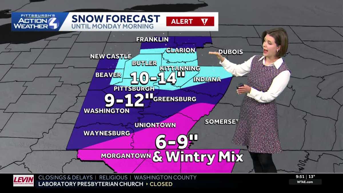
How much snow will we get?
This will be Pittsburgh’s biggest snowstorm since Snowmaggedon in 2010. The forecast calls for 9-12 inches of snow with some locations reaching 14 inches of snow. Bands of heavier snow will set up just north of Pittsburgh and up the totals. Areas that experience the wintry mix will see reduced accumulations of six to nine inches. Additional light snow is possible as the storm pulls away Monday morning.

Hearst OwnedHearst
A significant snow for all with locally higher amounts over a foot just north of Pittsburgh.
Very cold for the next week
After the snow ends, we will see a prolonged period of cold. Alert Days will extend through Tuesday for sub-zero wind chills, especially in the morning. The frigid air will keep morning temperatures in the single digits to around zero and highs in the teens all week long.

Hearst OwnedHearst
Harsh wind chills Tuesday morning of 15 to 25 degrees below zero.
Wednesday is an Impact Day for the bitterly cold air and a flurry chance. Substantial river icing is likely by the middle of next week.

Hearst OwnedHearst
No break from the cold outbreak as January comes to an end.
TODAY – Severe Weather Alert Day: A significant amount of snow. High: 27°.
TONIGHT – Severe Weather Alert Day: Snow tapers off. Low: 14°.
MONDAY – Severe Weather Alert Day: Morning snow then very cold. High: 18°, low: 0°.
TUESDAY – Severe Weather Alert Day: Sub-zero wind chills in the morning, partly cloudy with stray flurries. High: 16°, low: 3°.
WEDNESDAY – Impact Day: Harsh wind chills and flurries. High: 17°, low: 1°.