
Through all of this bitter cold, which still is locked in place through the weekend, we’re still closely tracking the likely development of a strong storm off the East Coast this weekend.
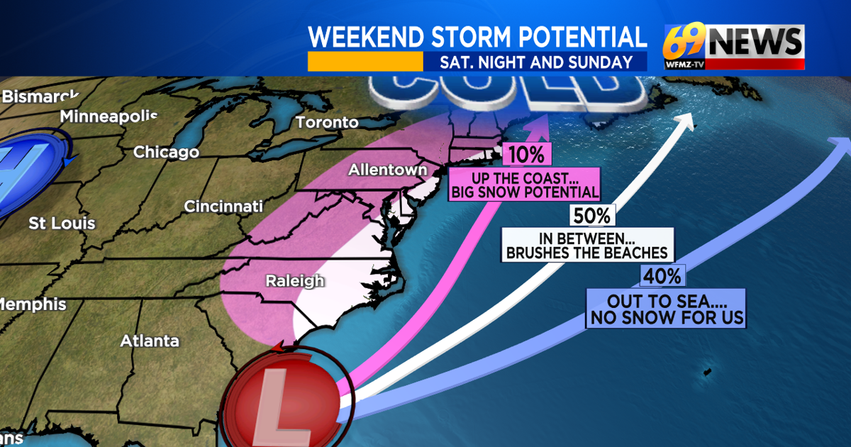
And while that storm is still likely to develop, and still could become quite strong and large, the chances of it bringing impactful snow to our area continues to slowly decrease. The chance isn’t zero just yet, but at least right now, it looks like the immediate coasts of New Jersey, Delaware, and Maryland will have the best chance for some accumulating snow from our mostly offshore storm.
With a full moon this weekend and increasing winds with our developing ocean storm, strong winds, tidal flooding, and beach erosion are possible impacts to coastal communities, depending on storm track and strength. Possible snowfall along the shore can range from little to none, a few inches, or something plowable, even if the actual storm stays well offshore. For most of our area, eastern Pennsylvania and western New Jersey, little to no snow is forecast, but we’ll keep a 30 percent chance of a little light snow later Saturday night into Sunday morning, just in case a little fringe snows can spread farther inland. Chances will be higher the farther south and east from the Lehigh Valley you travel.
The setup still bears watching, as small shifts can lead to big consequences and forecast changes, mostly along the coast. But the chances of this being a big winter storm for the entire area, which started the week as high as 30%, have now dropped to around 10%. If you’re rooting for a break from the snow, the trend, at least for now, is your friend.
The cold, meantime, shows no signs of relenting or mercy, with below zero nighttime lows and even more below zero wind chills overnight and each morning from Thursday through Saturday.
TRACK THE WEATHER:
LINKS: HOUR BY HOUR | RADAR | TRAFFIC