
ARCTIC CHILL REMAINS: Bitter temperatures could challenge record lows in south-central Pa.
METEOROLOGIST CHRISTINE FERREIRA. GOOD MORNING. 648 AND WE HAVE ANOTHER COLD WEATHER ADVISORY THAT IS IN EFFECT UNTIL 10 A.M. THIS MORNING. AND IT GETS REISSUED AT 7:00 THIS EVENING THROUGH 10 A.M. TOMORROW. AND WHAT THIS MEANS IS WE COULD SEE SUBZERO WIND CHILLS. WE ARE SEEING THEM THIS MORNING. SO HERE’S THE TEMPERATURE VERSUS THE WIND CHILL TODAY. OUR HIGH GETS UP TO 20. BUT LOOK AT THAT. WINDCHILL ONLY TO SEVEN AT BEST THIS AFTERNOON. SO WE WILL CONTINUE TO SEE THIS PESKY BRISK BREEZE. 5 TO 15MPH. REALLY PUTTING A CHILL IN THE AIR. IN ADDITION TO THAT, WE COULD BE SETTING SOME RECORDS OVER THE NEXT TWO DAYS FOR MORNING LOWS TOMORROW MORNING. THE FORECAST IS TWO. THE RECORD STANDS AT TWO. THAT WAS SET IN 2014 AND ON SATURDAY MORNING OUR FORECAST IS ZERO. THE RECORD STANDS AT TWO. SO WE’LL SEE HOW WE DO. BUT IT IS GOING TO BE INCREDIBLY COLD HERE AT THE END OF THE WEEK. TODAY’S IMPACT DAY FORECAST, DUE TO THE COLD, CALLS FOR A TEMPERATURE AROUND TEN AT 9:00 24 THE HIGH TODAY AND THEN BACK DOWN INTO THE TEENS. THIS EVENING WE START AND END THE DAY WITH SOME SUNSHINE, BUT RIGHT IN THE MIDDLE WE’LL SEE PARTLY SUNNY SKIES. THOSE CLOUDS BUBBLE UP IN THE AFTERNOON. TONIGHT, MOSTLY CLEAR. CHILLS WILL BE FIVE BELOW TO 15 BELOW ZERO. BITTER COLD TONIGHT. AND LOOK AT THOSE LOWS. 0 TO 4 FOR TOMORROW. ANOTHER IMPACT DAY. NO BIG CHANGE IN THE FORECAST. TEMPERATURES BARELY GET TO 20 DEGREES WITH SINGLE DIGIT CHILLS. MOSTLY SUNNY THROUGHOUT THE DAY TOMORROW. HERE’S YOUR CURRENT. IT’S NINE DEGREES IN LEWISTOWN ZERO. WE HAVE THE GOOSE EGG THERE IN YORK FOR YOU. 11 IN LEBANON, SEVEN IN LANCASTER AND NINE IN HARRISBURG AT IN JUST A 5 TO 15 MILE PER HOUR BREEZE. AND IT FEELS LIKE FIVE BELOW ON YOUR EXPOSED SKIN IN LEBANON. FEELS LIKE 12 BELOW IN YORK, EIGHT BELOW IN LANCASTER. SO PLEASE MAKE SURE ALL EXPOSED SKIN IS COVERED, ESPECIALLY IF YOU HAVE TO BE OUTDOORS FOR A LONG TIME THIS MORNING. HERE’S OUR STORM TEAM LIVE RADAR NETWORK. WE HAVE HIGH PRESSURE TO THE SOUTH AND THE ENERGY TO PRODUCE THAT COASTAL NOR’EASTER THIS WEEKEND. STARTING TO DROP DOWN FROM CANADA. THAT’S GOING TO GO OFF THE EAST COAST AND HEAD OUT TO SEA THIS WEEKEND, LEAVING US UNSCATHED. SO HERE’S A LOOK AT OUR FORECAST LOCALLY TODAY. WE GET THE MORNING SUN. THERE’S YOUR AFTERNOON CLOUD COVER AND THEN THE CLOUDS BACK AWAY LATER THIS EVENING. TONIGHT. SAME STORY. COLD. CLEAR, FRIGID. AND TEMPERATURES WILL BE SUBZERO FOR THE FEELS LIKE TOMORROW MORNING. IT’S CLEAR TO START. AND I DON’T THINK THOSE CLOUDS REALLY FORM UP IN THE AFTERNOON. WE SHOULD SEE MOSTLY SUNNY SKIES. THAT’S A LITTLE BIT OF A CHANGE. BUT REALLY, FOR THE WEEKEND, WE CONTINUE TO SEE THE DRY, FRIGID AIR EACH DAY. SATURDAY’S HIGHS DON’T GET OUT OF THE TEENS. SUNDAY’S HIGHS WILL BE IN THE 20S. LET’S TALK ABOUT THAT WEEKEND STORM. WE’VE BEEN SHOWING YOU A COMPARISON OF MODELS ALL WEEK. HERE’S THE EUROPEAN MODEL KEEPING THE STORM WELL OFFSHORE ON SUNDAY. AND THE AMERICAN MODEL ALSO IN THE SAME PLACE. ALMOST IDENTICAL LOCATION. SO THAT’S WHAT WE LIKE TO SEE THESE COMPUTER MODELS LINING UP, GIVING US A CONSENSUS THAT THE STORM STAYS WELL OFFSHORE AND PROVIDES NO IMPACT HERE IN THE SUSQUEHANNA VALLEY. SO IT’S VERY UNLIKELY THAT WE SEE ANY SNOWFALL FROM THE STORM. A LOWER CHANCE AS YOU HEAD CLOSER TO DELAWARE, NEW JERSEY, AND THEN RIGHT ALONG THE COAST, A MEDIUM TO HIGH CHANCE OF SEEING SOME SNOW, ESPECIALLY UP TO LONG ISLAND AND CAPE COD. BUT WE ON THE BACKSIDE OF THAT SYSTEM ARE GOING TO GET SOME WIND ON SUNDAY. I DO THINK IT’S A BREEZY TO WINDY DAY. SUNDAY’S HIGH IS 24 AND WE STILL WILL SEE WIND CHILLS AROUND THE SINGLE DIGITS BECAUSE OF THAT STORM. AS WE HEAD INTO NEXT WEEK, SOME MODERATION. UNLIKE IN THE 30S, IT’S LOOKING A LITTLE BIT WARMER. 32 FINALLY CRACKING THE FREEZING MARK ON TUESDAY AND WEDNESDAY, 34 ON THURSDAY AND FRIDAY. AN
ARCTIC CHILL REMAINS: Bitter temperatures could challenge record lows in south-central Pa.

Updated: 9:02 AM EST Jan 29, 2026
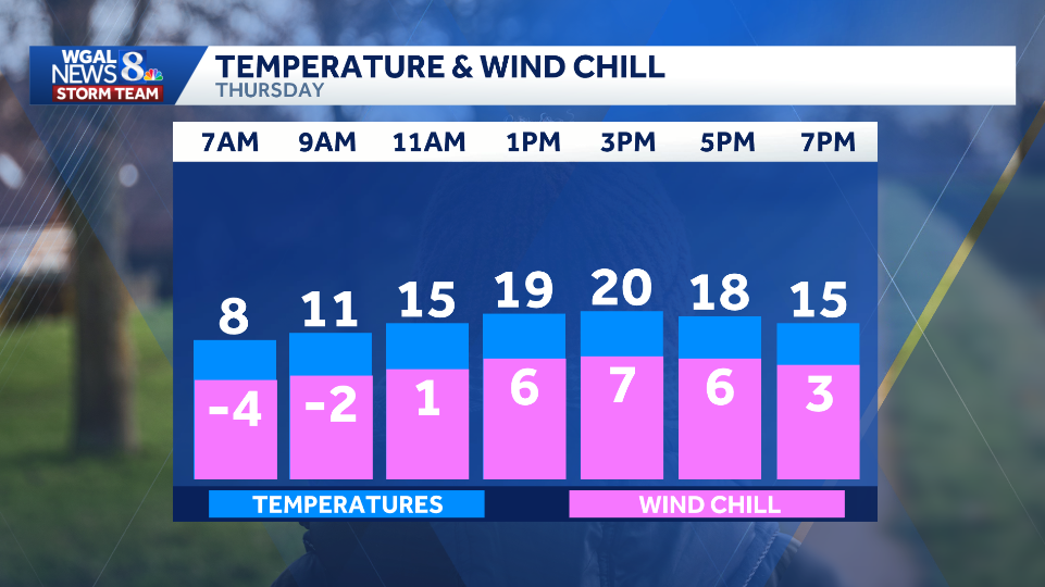
The Impact Week continues as an arctic blast remains in the Susquehanna Valley. A cold weather advisory remains in effect for all of south-central Pennsylvania until 10 a.m. Thursday.The National Weather Service has also issued another advisory from 7 p.m. Thursday to 10 a.m. Friday—marking the fourth cold weather advisory this week.ThursdayMorning: Sunny and frigid with temperatures in the single digits and below-zero wind chills.Afternoon: Partly sunny, then clearing toward evening. Brisk 10-20 mph winds make it feel like single digits. High near 20 degrees. Night: Mostly clear with a light breeze 5–10 mph and sub-zero wind chills.Possible record-breaking lowsThe extreme cold and bitter winds could challenge, and even break, record low temperatures in the region. Friday morning: Lows could drop to 2 degrees, tying the record low of 2, set in 2014. Saturday morning: Temperatures expected to be near zero, which would break the record of 2 degrees, set in 1948. When does the Impact Week end?The WGAL News 8 Storm Team has declared every day through Saturday an Impact Day as extreme arctic cold brings dangerous low temperatures and sub-zero wind chills.Thursday marks the sixth consecutive day below freezing. SOUTH-CENTRAL PA WEATHER RESOURCES: INTERACTIVE RADAR | ACTIVE WEATHER ALERTS | CURRENT CONDITIONS | HOURLY FORECAST | 10-DAY FORECAST | WEEKEND FORECAST | MAP ROOM | DOWNLOAD THE APP | WEATHER EMAILS
The Impact Week continues as an arctic blast remains in the Susquehanna Valley.
A cold weather advisory remains in effect for all of south-central Pennsylvania until 10 a.m. Thursday.
The National Weather Service has also issued another advisory from 7 p.m. Thursday to 10 a.m. Friday—marking the fourth cold weather advisory this week.

ThursdayMorning: Sunny and frigid with temperatures in the single digits and below-zero wind chills.Afternoon: Partly sunny, then clearing toward evening. Brisk 10-20 mph winds make it feel like single digits. High near 20 degrees. Night: Mostly clear with a light breeze 5–10 mph and sub-zero wind chills.

Possible record-breaking lows
The extreme cold and bitter winds could challenge, and even break, record low temperatures in the region.
Friday morning: Lows could drop to 2 degrees, tying the record low of 2, set in 2014. Saturday morning: Temperatures expected to be near zero, which would break the record of 2 degrees, set in 1948.


When does the Impact Week end?
The WGAL News 8 Storm Team has declared every day through Saturday an Impact Day as extreme arctic cold brings dangerous low temperatures and sub-zero wind chills.
Thursday marks the sixth consecutive day below freezing.


SOUTH-CENTRAL PA WEATHER RESOURCES: INTERACTIVE RADAR | ACTIVE WEATHER ALERTS | CURRENT CONDITIONS | HOURLY FORECAST | 10-DAY FORECAST | WEEKEND FORECAST | MAP ROOM | DOWNLOAD THE APP | WEATHER EMAILS