A prolonged stretch of dangerous and potentially record-setting cold will continue to grip the region through Friday, with daytime highs well below freezing and overnight lows in the single digits producing sub-zero wind chills.
A rapidly deepening coastal storm is expected to develop off the East Coast this weekend, bringing the possibility of snow, strong winds and coastal flooding impacts — particularly for areas southeast of the Lehigh Valley toward the shore.
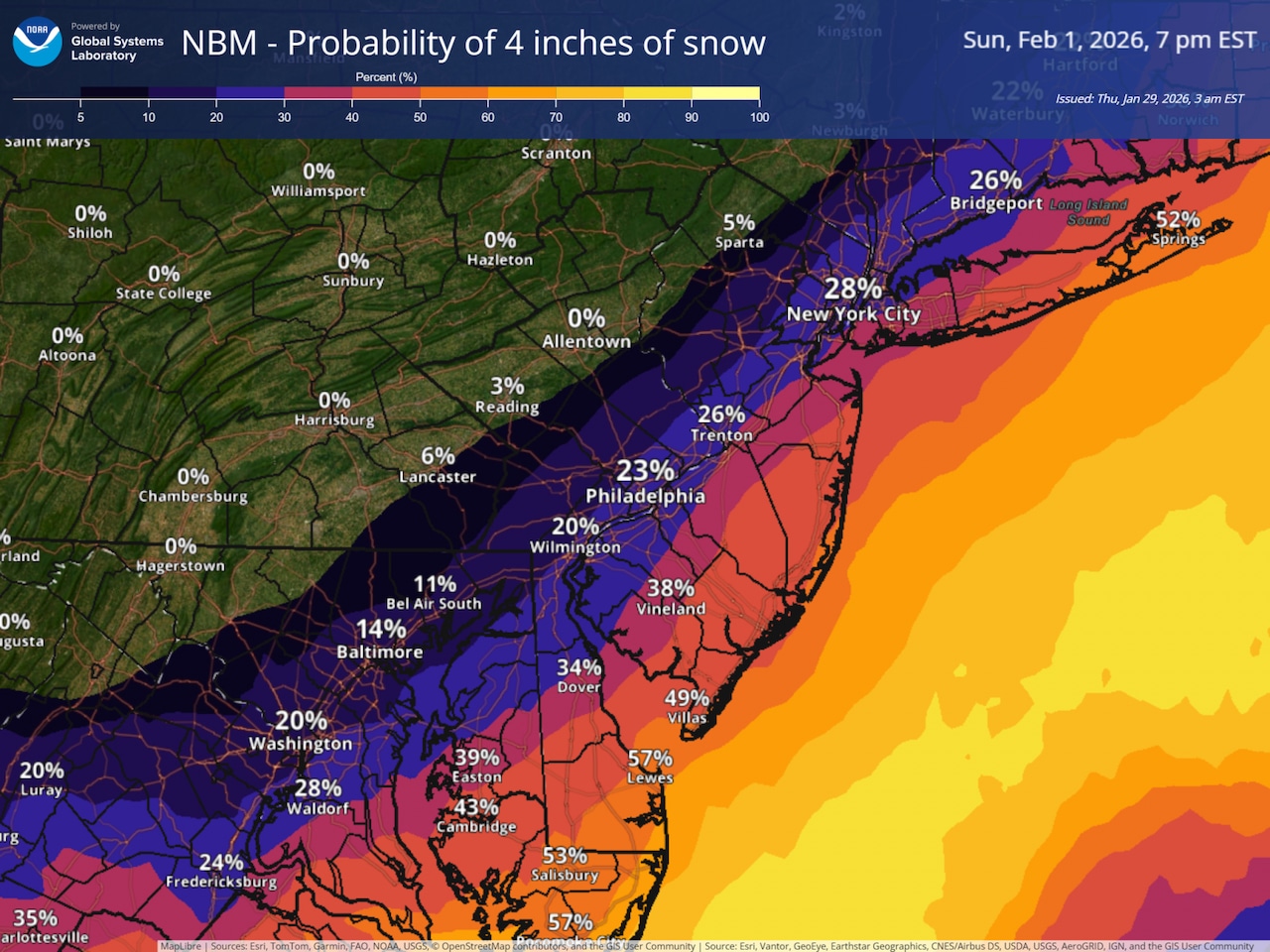
For the Lehigh Valley region, the National Weather Service on Thursday forecast a 5% chance or less of receiving 4 inches of snow through Sunday night. At Lehigh Valley International Airport, the forecast includes a slight chance of snow from about daybreak to noon Sunday.
The National Weather Service extended the Cold Weather Advisory through 10 a.m. Friday for Lehigh, Northampton and Warren counties and surrounding areas. Another reinforcing shot of cold air will move down from the northwest Thursday through Friday, with Thursday night and Friday night expected to see the coldest temperatures of the event.
Overnight lows are likely to reach near zero or below zero across much of the region, while Friday highs are expected to remain in the teens. Some of the region’s climate sites have a chance to set record low temperatures and record low maximum temperatures over the coming days.
The weekend coastal storm presents a more uncertain but potentially significant threat. Forecast models indicate rapid cyclogenesis will begin Saturday off the southeast coast, with the low pressure system moving north and east Saturday night through Sunday.
The exact track remains uncertain, but the latest guidance suggests the Lehigh Valley area will be near the northwestern fringe of the storm’s precipitation shield.
If the storm tracks closer to the region, impacts could include 1 to 2 inches of snow for eastern Pennsylvania. Strong winds of 15 to 25 mph with gusting to 35 mph are possible inland, reaching 50 mph along coastal areas, which could cause power outages.
Regardless of snow accumulation, forecasters have growing confidence that the storm will track close enough to bring those increasing winds to the area Saturday night into Sunday.
The very cold temperatures in place both at the surface and aloft mean all precipitation will fall as snow. Probabilities for plowable snow (greater than 2 inches) range from 25 to 35% near the Interstate 95 corridor to 60 to 70% near the coast, with lower probabilities northwest of the urban corridor.
By Sunday evening, the storm should be rapidly pulling away to the northeast, ushering in generally tranquil but cold weather for early next week.
Winds and temperatures are expected to relax by Monday, with the cold weather advisory likely ending by that time as the air mass begins to moderate.
Current weather radar