
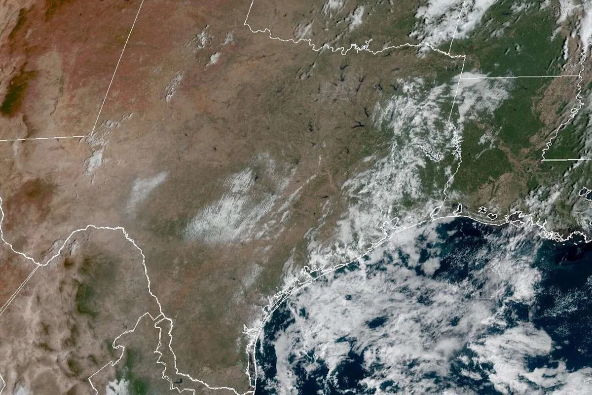
For at least 40 days and 40 nights, San Antonio has gone without significant rainfall, and the city’s dry spell will likely persist this weekend and into next week, even after the arrival of a cold front, according to the National Weather Service.
The extended seven-day forecast from the weather service calls for unusually warm afternoons with only slight rain chances this weekend closer to the Texas Gulf Coast and along the U.S. 77 corridor.
San Antonio on Saturday will start out mostly cloudy before the skies open up by 10 a.m. The abundant sunshine Saturday will help lift afternoon temperatures to 94 degrees – an especially high reading that’s a full dozen degrees warmer than normal for Oct. 18. At night, skies will remain clear while overnight temperatures stay above 69 degrees.
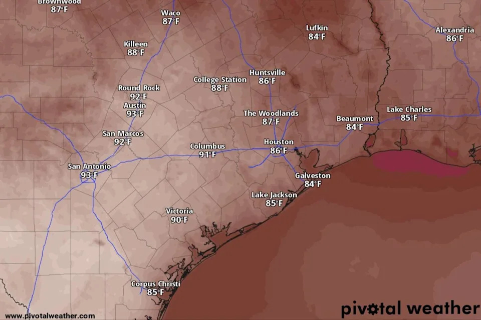
San Antonio temperatures will soar into the lower 90s by 4 p.m. Saturday, according to the National Blend of Models, a composite weather forecast model. (National Blend of Models/Pivotal Weather)
With a weak cold front approaching Texas from the north, the light southwest winds blowing across South Texas will become northerly after midnight, the weather service said.
Sunday forecast
The cold front, though, won’t be enough to trigger substantial rainfall, and forecasters give South-Central Texas no more than a slim 20% chance of rain. Instead, the cooler and drier air mass behind the front will diminish humidity in the region.
“On Sunday, with the passage of the Pacific front mentioned above, (relative humidity) values will fall to between the upper teens to mid-20s for most, if not all of South-Central Texas,” the weather service said in a forecast posted online Friday.
{ “__type”: “devHubFreeformEmbed”, “__id”: “Datawrapper”, “__fallbackImage”: “https://datawrapper.dwcdn.net/oUaNC/mobile.png”, “__data”: { “datawrapper_id”: “oUaNC” } }
San Antonio on Sunday will be sunny but blustery, as north-northeast winds of 10 to 15 mph include gusts as strong as 25 mph. The cold front will lower daytime temperatures, but not by much. Afternoon temps will peak at 87 degrees, which still would be five degrees warmer than normal.
In the evening, the clear skies and dry air will allow radiational cooling to occur. Without heat-trapping wator vapor from humidity or clouds, much of the heat accumulated by the ground gets radiated back into the atmosphere at night, lowering temperatures even more. Overnight temps could plummet to as low as 61 degrees Sunday night into Monday morning.
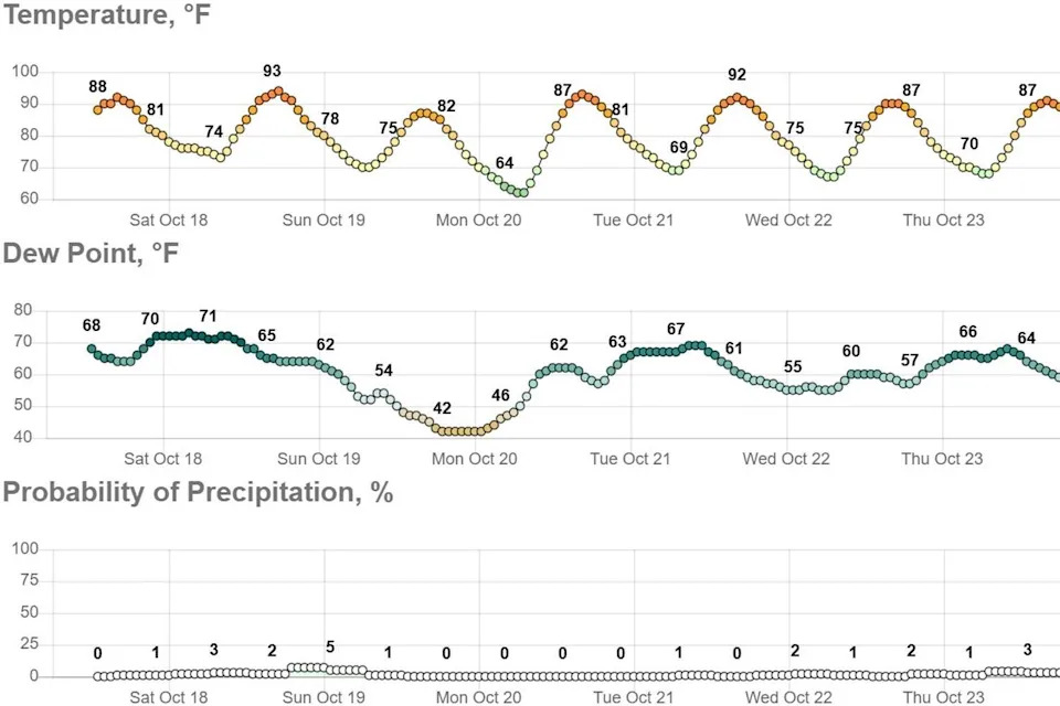
In the extended forecast for San Antonio, the arrival of a cold front and its dry air mass behind it will cause a slight dip in air temperatures but also a more noticeable drop in dew point temperatures, which are linked to atmospheric moisture levels. (National Weather Service)
Meanwhile, in parts of Texas near and east of San Antonio, forecasters warned of a growing threat from wildfire-friendly conditions.
“Light east to northeast surface winds are forecast, with portions of the Coastal Plains and I-35 Corridor showing speeds around 10 to 12 mph mid- to late afternoon,” the weather service said. “Dry conditions, lack of recent rainfall, and some dry fuels would pose an elevated risk for wildfires over those locations.”
Monday and next week
Afternoon temperatures will rebound next week, with daily forecast highs hitting or exceeding 90 degrees again, even as “normal” highs for this time of year continue to descend into the lower 80s.
{ “__type”: “devHubFreeformEmbed”, “__id”: “Datawrapper”, “__fallbackImage”: “https://datawrapper.dwcdn.net/xsK77/mobile.png”, “__data”: { “datawrapper_id”: “xsK77” } }
San Antonio on Monday and Tuesday is expected have nearly identical weather on both days: Sunny skies with temperatures as high as 92 degrees amid warm southerly winds. Clear skies on both nights could include overnight to predawn temperatures as low as 67 degrees, forecasters said.
“Mid-level ridging (of high atmospheric pressure) returns quickly on Monday and Tuesday, resulting in warm and dry days,” the weather service said in its forecast. “Yet another dry cold frontal passage may occur on Tuesday afternoon, but considerable uncertainty in the medium-range guidance beyond Monday makes it difficult to say.”
This article originally published at Dried-out San Antonio will bake in the 90s Saturday, but could a looming cold front help?.