
LUBBOCK, Texas (KCBD) – After starting the day with the coldest temperatures since early December, with lows in the teens and 20s, a warming trend begins today and continues through the first weekend of the New Year.
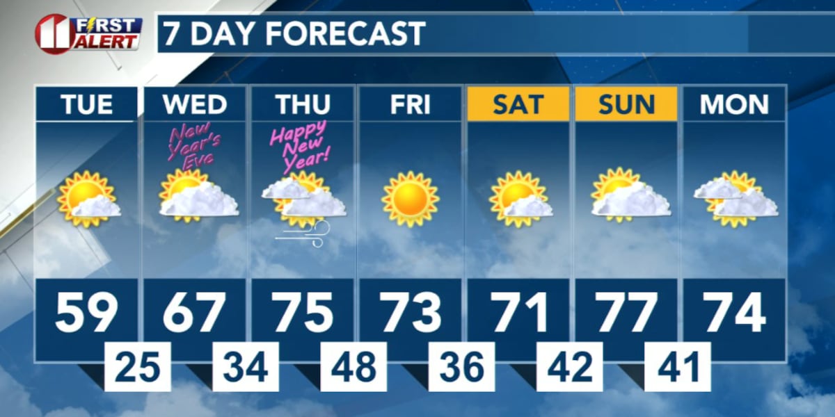
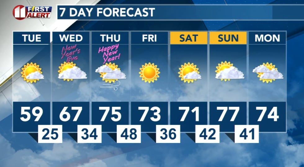
Overall, dry conditions and above-normal temperatures dominate my forecast the rest of the week and the weekend ahead.
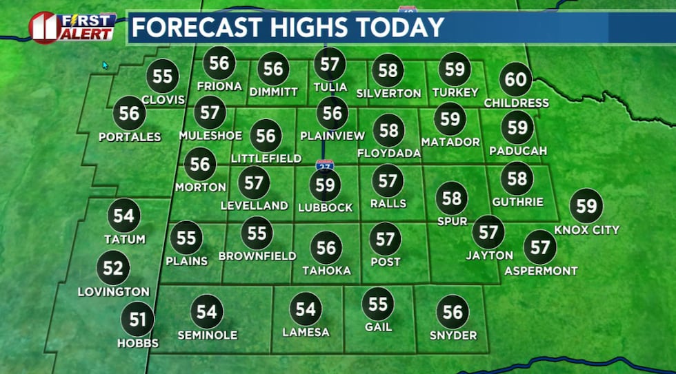 Highs today near to slightly above average for the end of the year.(KCBD First Alert)
After a cold start, temperatures this afternoon will peak about five degrees above average for the date. Other than a few high clouds the day will be sunny.
Winds, which have been light this morning, will become breezy, generally from the southwest around 10 to 20 mph. There may be occasional stronger gusts.
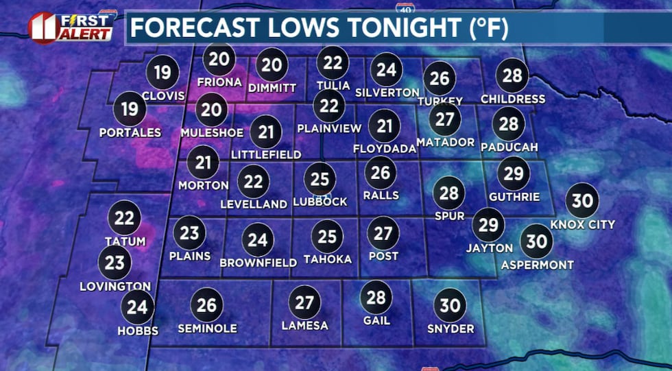 Another cold night ahead.(KCBD First Alert)
Just ahead another cold night. Temperatures will drop into the upper teens to upper 20s. A few clouds will come and go. The wind will be light.
Tomorrow, New Year’s Eve day, our area will warm even more. After a cold early morning, afternoon temperatures will climb into the 60s. Wednesday will be partly cloudy with a light wind for the most part.
 Overall, dry conditions and above-normal temperatures dominate my forecast the rest of the week and the weekend ahead.(KCBD First Alert)
My outlook for New Year’s Eve night remains unchanged. Partly cloudy in the evening, becoming chilly. Then mostly cloudy overnight. While it will get cold, lows in the upper 20s to the upper 30s are mild for the first morning of the new year.
New Year’s, Thursday, will be mostly cloudy under an overcast sky. There may be a few sprinkles, but I don’t expect any measurable rain. It will become windy, with westerly winds increasing to 20-30 mph (stronger gusts likely at time) across the Caprock, with speeds of 15 to 25 mph off the Caprock, the Rolling Plains area.
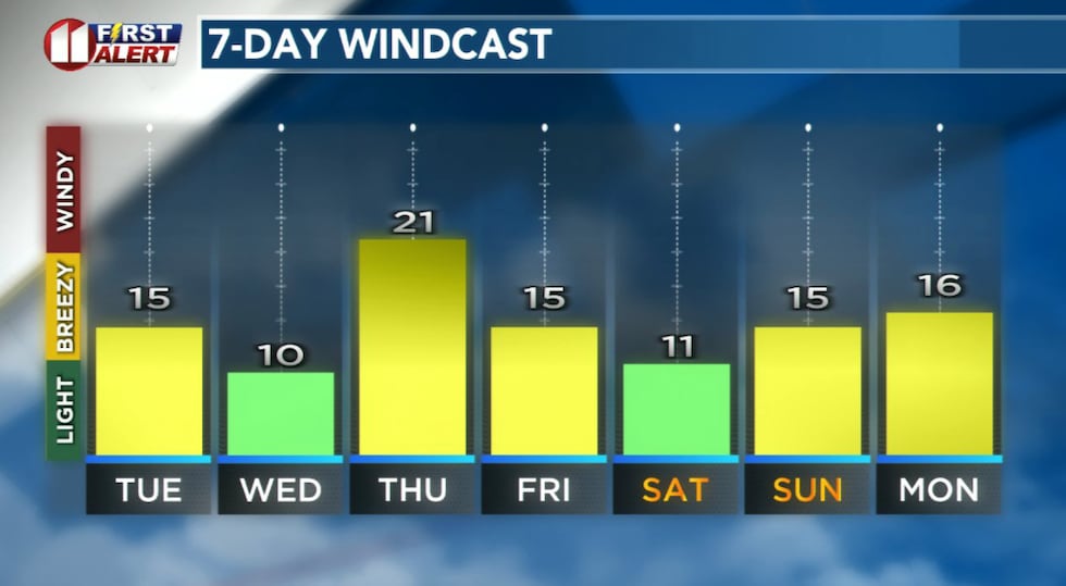 Forecast peak sustained winds are shown in this graph. Peak gusts will exceed the values shown here.(KCBD First Alert)
Above normal temperatures continue through the first weekend of the New Year. There is no signs of any significant precipitation.
On This Date
On this date in 2010, an intense storm system and upper jet stream contributed to high-based convection over the western South Plains of West Texas during the evening. The thunderstorms produced damaging wind gusts measured as high as 76 mph and blowing dust. Winds downed utility poles and lines which sparked a 2,000 acre wildfire west of Levelland.
(National Weather Service Lubbock)
Copyright 2025 KCBD. All rights reserved.