

El Paso had its third-warmest year on record in 2025, trailing only the two previous years as climate change continues to increase temperatures in the Chihuahuan Desert.
Before 2017, the average annual daily temperature in El Paso had never reached 68 degrees in records that go back to 1887. The average temperature has been at or above 69 degrees each of the past three years.
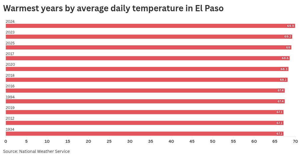
Nine of the 11 hottest years on record for El Paso have occurred since 2012, with the six hottest all coming since 2017.
El Paso had its warmest December on record to close out 2025. The average daily temperature was 55 degrees, shattering the previous record of 53.1 that had stood since 1899.
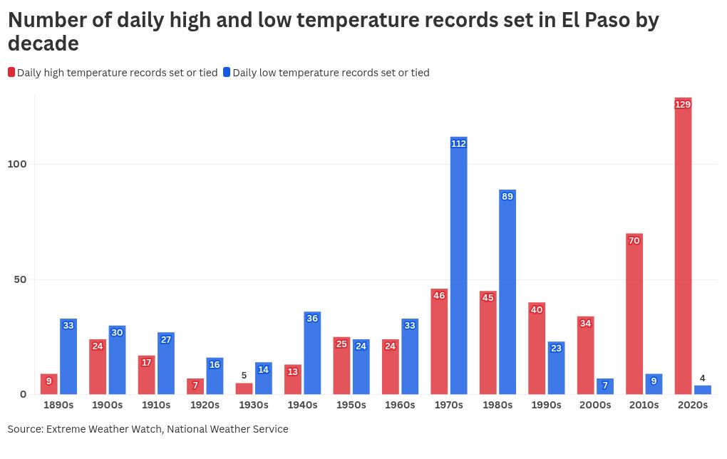
In 2025, El Paso set or tied 29 daily high temperature records, according to National Weather Service data compiled by Extreme Weather Watch. El Paso had no days in 2025 with a new daily record for low temperatures.
The last time El Paso set or tied a daily low temperature record was on Feb. 14, 2021. Since then, El Paso has had 99 days that set or tied a record for daily high temperature.
That’s an indication that carbon pollution is responsible for El Paso’s record high temperatures in recent years, according to Climate Central, an independent group of scientists and communicators who research and report facts about the changing climate and how it affects people’s lives.
“In a stable climate, extreme daily highs and lows would each account for about half of all records. But because of human-caused warming, record highs are outpacing record lows across the U.S.,” according to Climate Central.
Since 2010, El Paso has set or tied 199 records for daily high temperatures and only 13 for record daily low temperatures. In earlier decades, the records were more evenly distributed between record warm temperatures and record cool temperatures.
El Paso has been one of the nation’s most-impacted cities by rising temperatures as the global climate has changed.
El Paso’s average daily temperature warmed by 5.4 degrees between 1970 and 2023. Among U.S. cities, only Reno and Las Vegas in Nevada warmed more in that time, according to Climate Central.
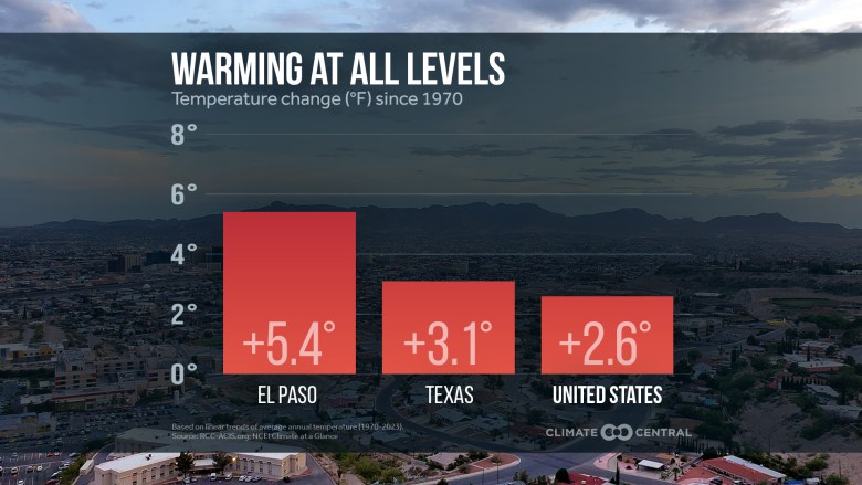 The average daily temperature in El Paso warmed more than twice as fast as the national average between 1970 and 2023, and 74% faster than the state average. (Illustration courtesy Climate Central)
Although the last three years have been the warmest on record for El Paso, rainfall was significantly higher this year than in 2023 or 2024.
El Paso recorded 9.21 inches of precipitation in 2025 – close to the historic average for the region. Precipitation in 2023 and 2024 was below 5 inches both years, the first time that had happened in consecutive years since 1909 and 1910.
Related
LISTEN: EL PASO MATTERS PODCAST