
LUBBOCK, Texas (KCBD) – As a weather system approaches from the west, winds and temperatures will increase across the South Plains today. More wind will follow tonight and tomorrow. I do have some good news about our weather this weekend.
New Year’s Day
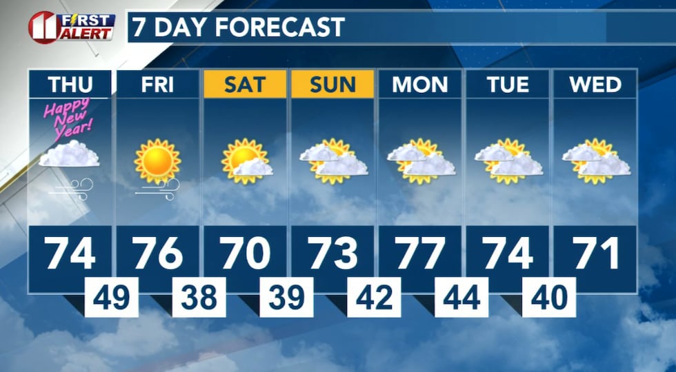
As we ring in 2026, expect a windy and warm afternoon. The westerly wind will increase to 20 to 30 mph, with stronger gusts at times, over the western KCBD/FOX34 viewing area. Speeds will come close to that elsewhere on the Caprock, including Lubbock. Speeds in a 10 to 20 mph range are expected off the Caprock, the Rolling Plains area.
 Cloudy, gusty, with seasonably warm temperatures this afternoon.(KCBD First Alert)
In addition to windy and seasonably warm, the afternoon will be mostly cloudy. There may be a few sprinkles. I do not expect any measurable rain. I do expect roads to remain dry.
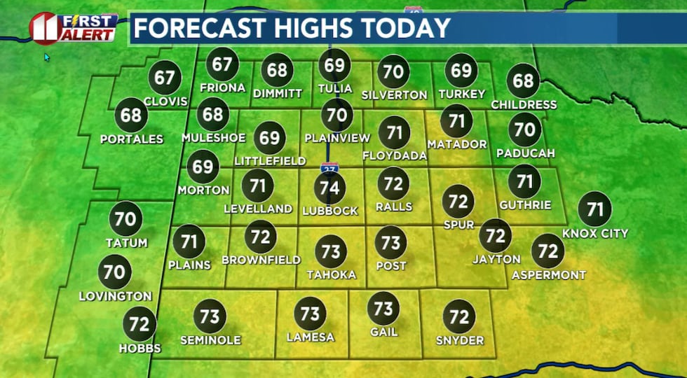
Highs today will be as much as 15 to 20 degrees above the January 1 average. That number for Lubbock is 54°. Lubbock’s record high for the first of the year is 76°, set in 1977.
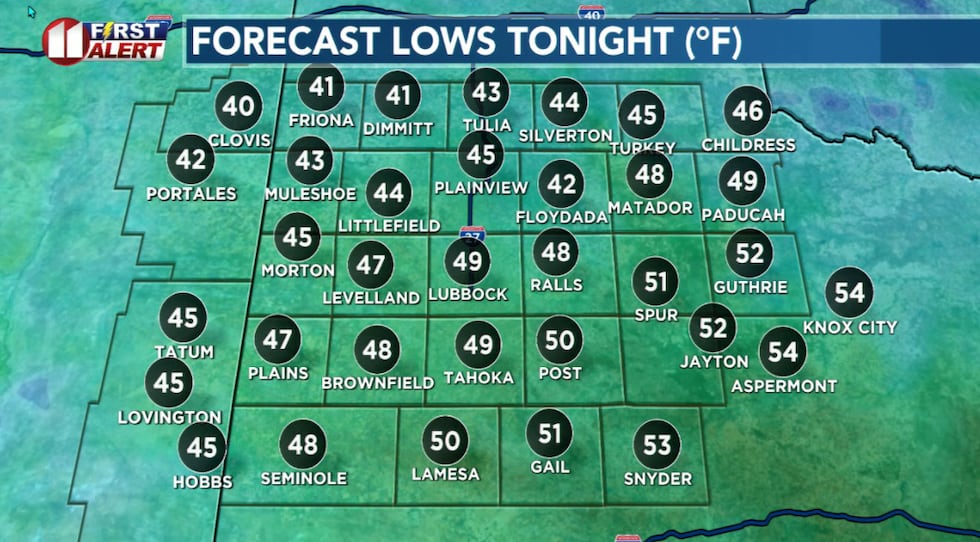 Mild morning lows with a chilly breeze early Friday morning.(KCBD First Alert)
Skies will clear from west to east this evening. Winds, however, will remain gusty through the night.
More Wind
Under a sunny sky, winds tomorrow will rapidly increase. The northwesterly wind is expected to increase to around 25 to 35 mph, with gusts near 50 mph, over the western viewing area. The central viewing area, including the Lubbock and Plainview areas, are likely to experience sustained speeds of 20 to 30 mph. Gusts of 40 to 50 mph are possible.
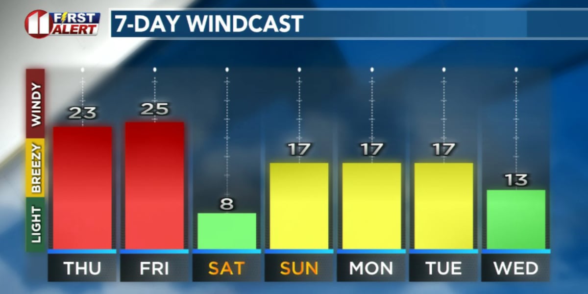
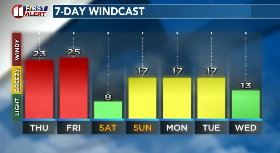 Forecast peak sustained winds are shown in this graph. Peak gusts will exceed the values shown here.(KCBD First Alert)
There may be blowing dust in the strong winds, which may cause areas of low visibility. Both today and tomorrow are NO BURN DAYS due to the wind, warmth, and continued dry conditions.
Take some time this morning to put away or otherwise secure any outdoor items which may be blown about or even become airborne in a strong wind. This might include trash cans, patio furniture, even decorations.
Exercise extra caution when driving, especially on north-south oriented roadways in open areas. The gusty winds from the west will be broadsiding vehicles.
 Winds and temperatures will increase across the South Plains today and tomorrow.(KCBD First Alert)
Weekend and Beyond
Saturday is shaping up to be quite pleasant. It will be mostly sunny. Winds will be light. Temperatures will peak about 15 degrees above average for the time of year. Highs will range from the mid-60s to the low 70s.
Dry and unseasonably warm weather will continue from Saturday through at least early next week. Expect highs mainly in the low to mid-70s, well above average for early January in Lubbock. Temperatures may approach record highs for the time of year.
More seasonable conditions may return by late next week.
Happy New Year from your First Alert Weather Team!
On This Date
On this date in 1983, a memorable New Years Day snowstorm struck much of the South Plains before tapering off on the 2nd. Locations such as Lubbock, Abernathy and Floydada measured a whopping 10 inches of snow, with 12 inches recorded in Brownfield and Spur. Although considerable travel problems developed, no injuries or casualties were reported. This otherwise significant snowstorm was just a mere taste of what was to come later this month when historic and record-breaking snows would paralyze the region.
(National Weather Service Lubbock)
Copyright 2025 KCBD. All rights reserved.