
A weak cold front that was pushing through Texas over the weekend is expected to kick up blustery northerly winds with gusts as strong as 35 mph early Sunday, and San Antonio temperatures could be capped at only the mid-80s, according to the National Weather Service. The winds, dry air and rainless weather, though, are also raising concerns about the risk of fast-spreading wildfires.
Sunday and a cold front
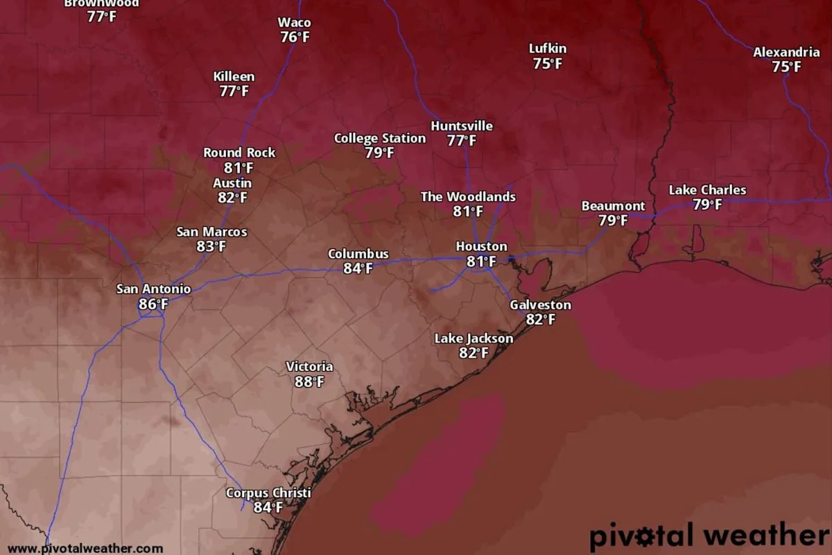
In the wake of the cold front, San Antonio on Sunday will have sunny skies, but cool north-northeast winds of 10 to 20 mph, including gusts as strong as 30 mph, will help keep afternoon temperatures below 85 degrees. Although that would still be a few degrees warmer than normal for Oct. 19, it would be as close to normal for this time of year as we’ve seen all month.
{ “__type”: “devHubFreeformEmbed”, “__id”: “Datawrapper”, “__fallbackImage”: “https://datawrapper.dwcdn.net/oUaNC/mobile.png”, “__data”: { “datawrapper_id”: “oUaNC” } }
“Breezy conditions are forecast Sunday morning through early afternoon across the Hill Country and along and east of the I-35 corridor, with north to northeast winds sustained around 20 mph and gusts around 30 mph in some areas,” the weather service said in a forecast bulletin posted online Saturday. “The wind speeds are forecast to gradually diminish late afternoon and evening Sunday, with a weak southeast flow already redeveloping along the Rio Grande.”
With drought intensifying across the state, the Texas A&M Forest Service has placed Bexar County under a high risk of fast-spreading wildfires for Sunday and under a moderate risk on Monday.
Some fire weather conditions, such as dry vegetation, gusty winds and low humidity are worse in areas east of San Antonio. For instance, along the Interstate 10 corridor, Columbus has a 50-60% chance of wind gusts stronger than 20 mph and humidity levels below 30% on Sunday.
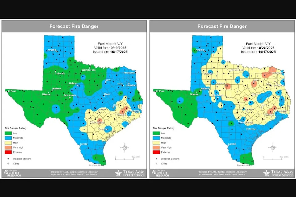
The Texas A&M Forest Service has placed Bexar County under a high risk of fast-spreading wildfires for Sunday and under a moderate risk on Monday. (Texas A&M Forest Service)
In San Antonio at night, a much drier air mass behind the cold front will settle in the region. In San Antonio, the clear skies and dry air will make radiational cooling near the ground more effective and we could see temperatures overnight and before dawn early Monday sink into the upper 50s or lower 60s.
Forecasters said South-Central Texas can expect a “cooler and dry Sunday night, especially across the eastern Hill Country and along and east of the I-35 corridor where winds decouple.” Decoupling in meteorology refers to when one layer of the atmosphere stops interacting with an adjacent layer.
Monday, Tuesday and a second front
Although San Antonio could wake up Monday to some of the chilliest temperatures since mid-May, afternoon temperatures in the upcoming week will return to the 90-degree mark.
“Southerly winds quickly strengthen across the entire area by midday Monday with a big rebound in temperatures forecast as highs reach back into the upper 80s to mid-90s,” the weather service said in its forecast bulletin.
San Antonio on Monday will be sunny and daytime temperatures could climb to 92 degrees, boosted by warm but gusty south-southwest winds of 5 to 10 mph. That projected high temperature would be 10 degrees warmer than normal for Oct. 20.
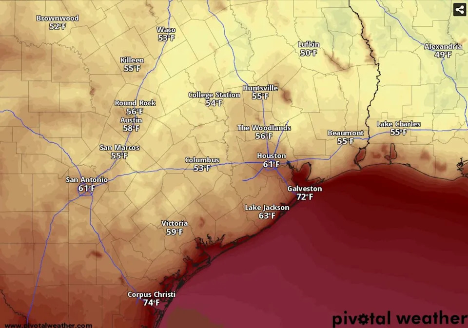
Predawn temperatures could dip into the upper 50s or lower 60s by 7 a.m. Monday across South-Central Texas, according to the National Blend of Models, a composite forecast model. (National Blend of Models/Pivotal Weather)
At night, skies over San Antonio will remain clear but overnight temperatures are expected to stay above 66 degrees.
“A progressive pattern sets in, as a trough (of low atmospheric pressure) to the north sends another cold front into the area on Tuesday,” the weather service said. “It appears moisture recovery will be minimal Monday night, and… this second front is currently forecast to be dry.”
Despite yet another weak cold front on deck, San Antonio can expect similarly dry, rain-free weather for most of the coming week.
Tuesday, Wednesday and Thursday share a forecast calling for plenty of sunshine, high temperatures around 90 degrees and nighttime lows around 67 degrees. The only significant change the weather service is confident of is the return of humid, moisture-rich air carried in by southerly winds out of the Gulf of Mexico.
“Southerly return flow quickly re-establishes over the region by Wednesday,” forecasters said. However, they have “low confidence in the forecast at the end of next week regarding whether or not another cold front makes it Friday and any rain chances associated with it.”
This article originally published at Weak front set to bring San Antonio strong winds, dry air but also higher wildfire danger.