
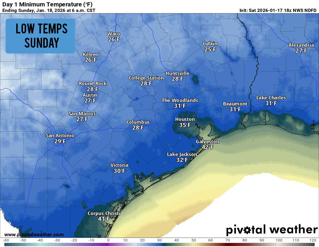
Shown are the expected low temps across the region Sunday morning. Many across Southeast Texas will encounter a brief freeze.
Pivotal Weather
After what has been a warm start to January, a relatively strong cold front finally did sweep through the region on Saturday, bringing a 15-20 degree drop in temperatures to the Houston area. Temps dropped quickly Saturday night, and a freeze is possible for parts of Southeast Texas early Sunday.
Following the cold start to Sunday, the area is expecting more up-and-down temps this week, as well as decent rain chances by the middle of the week. Here’s a breakdown of how the week will play out.
Sunday’s freezing (or near-freezing) start
Bundle up before walking out the door Sunday. Temperatures near downtown Houston are expected to hover in the mid-30s from4 to 8 a.m., likely just a few degrees above the freezing mark. However, as you start moving out of the central part of the city, temps will be slightly colder, likely falling to the freezing mark in the northern and western parts of the city.
Article continues below this ad
Cities such as Katy, Sugar Land, Conroe, and The Woodlands are expected to experience a light freeze, with lows from 29 to 31 degrees. In these areas, be sure to bring in potted plants, and drain and cover outdoor plumbing and faucets.
Farther from the city, a hard freeze is possible in areas like Crockett, Huntsville and College Station, where lows will dip to 25 to 28 degrees early Sunday.
Warming up: Thankfully, the freezing temps will not last long, as bright sunshine will promote rising temps throughout the day. Houston temps will rise into the 40s by 9:30 a.m., reaching the 50-degree mark by around noon. High temps will top out in the mid- to upper 50s, slightly below average for mid-January.
This week’s forecast
With sunshine continuing throughout the area Monday, temperatures will be noticeably warmer than on Sunday. Morning lows will stay chilly, near 40 degrees, but afternoon highs are expected to reach the mid-60s. Winds will be light, and no rain is expected anywhere across the region.
Article continues below this ad
Another cold front is expected to approach the region Tuesday, but this front will not be nearly as strong as the last. Afternoon highs will only drop by about 5 degrees, topping out at around 60 Tuesday afternoon. Clouds will increase as well, but mainly dry weather will persist.
Shown are the expected rainfall totals on Wednesday and Thursday.
Pivotal Weather
By Wednesday, a plume of Pacific moisture is expected to move into the state, likely resulting in showers and weak storms across Southeast Texas. Rain chances will rise to around 50-60% across the region, with some showers continuing into Thursday.
Rainfall totals are not expected to be huge, but parts of the Houston area could see up to an inch. Areas closer to the coast could pick up slightly higher accumulations. Temperatures will stay cool during this time, with highs expected in the mid-60s Wednesday and Thursday.
Article continues below this ad
By the end of the week and into the weekend, warmer high temps in the 70s are possible. However, some long-range weather models do show a potential strong cold front by Jan. 25-26. Stay tuned to houstonchronicle.com/weather for continued daily updates.