A sharp temperature drop arrives this weekend, but will there be any wintry precip? Here’s what we know – and don’t know.
AUSTIN, Texas — The KVUE Weather Team has issued a Weather Impact Alert for Saturday through Monday morning due to an incoming Arctic cold front. Confidence is high that a significant cold snap and hard morning freezes are on the way. Confidence in any wintry precipitation remains much lower. With that in mind, let’s walk through what we know right now and what we are still watching closely.
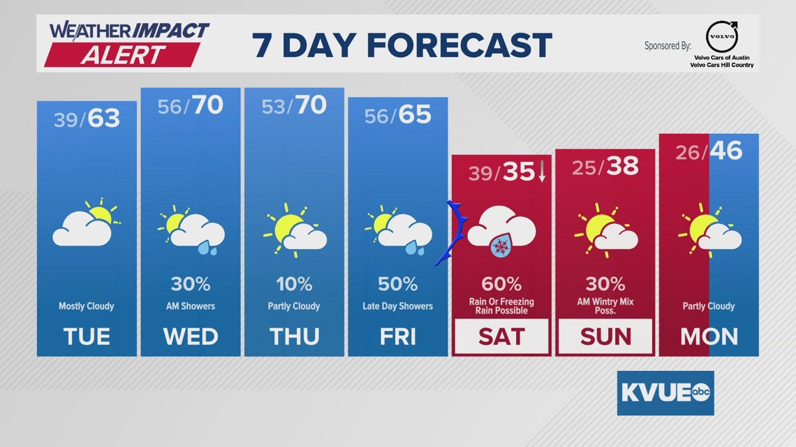
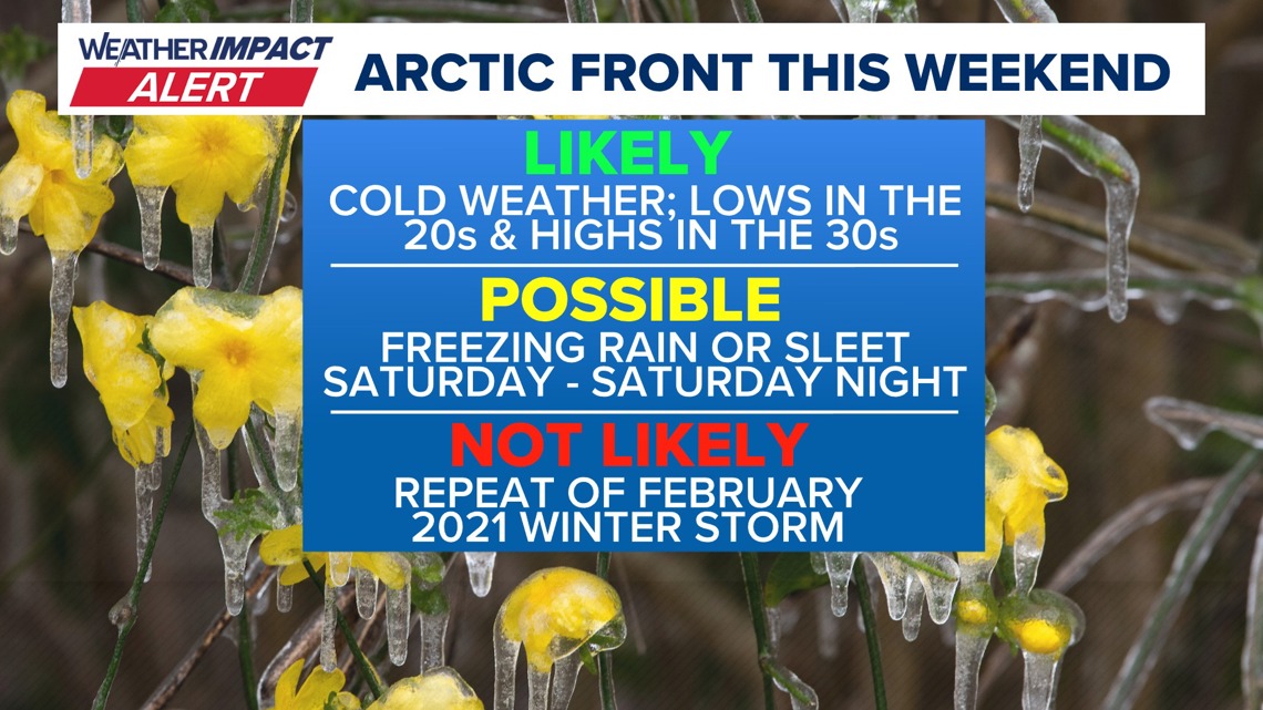
An Arctic front is expected to move through Central Texas on Friday evening. Behind the front, temperatures will fall quickly overnight, dropping into the 30s by Saturday morning. Temperatures are then expected to continue falling through the day on Saturday, with readings potentially dropping to or below freezing by late afternoon or evening.

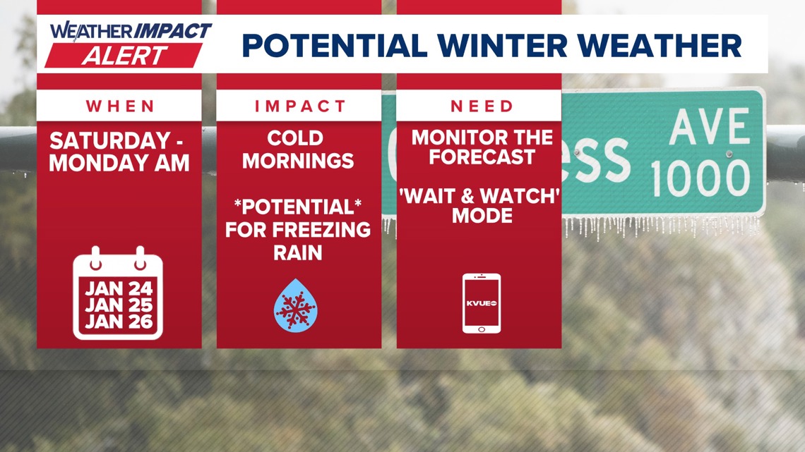
This sets the stage for a prolonged period of cold weather. Both Saturday and Sunday afternoons may struggle to warm out of the 30s in parts of the area. Sunday morning and Monday morning are shaping up to be the coldest periods, with a widespread hard freeze increasingly likely. Air temperatures could drop well into the 20s for much of Central Texas, with some of the coldest locations potentially dipping into the teens.
As for winter precipitation, this remains a lower-confidence part of the forecast.
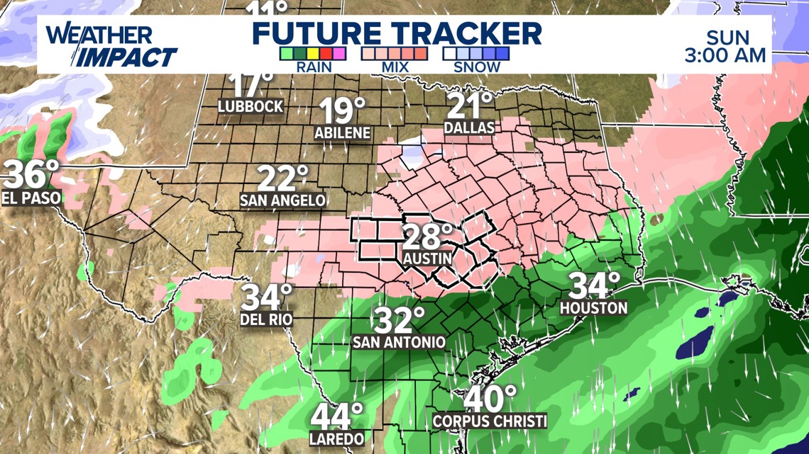
Based on current trends, the most likely scenario would involve rain developing on Friday night as temperatures are falling. Much of Saturday could feature cold but still-above-freezing temperatures, resulting in chilly rain for most of the Austin area. Locations north of Austin would have a higher chance of seeing some freezing rain or sleet mixed in.
The greatest window for any freezing rain or sleet currently appears to be late Saturday into Saturday night, before precipitation tapers off by Sunday morning. With a shallow Arctic air mass in place, freezing rain or sleet would be favored over snow if temperatures do drop below freezing while precipitation is still ongoing.

Rain and wintry precipitation chances should continue to diminish through the day on Sunday, but cold conditions will remain locked in. Another hard freeze looks likely Sunday night into Monday morning.
In summary, confidence is high that Central Texas is headed for a meaningful cold snap with multiple hard freezes. Confidence in wintry precipitation remains low, but it is something we will continue to monitor closely, especially late Saturday into Saturday night.

We will continue refining the forecast over the coming days and will provide regular updates as confidence increases. The extended forecast can be found below: