
FORECAST HIGHLIGHTS
FRIDAY NIGHT: Showers, a storm, front arrives
FIRST HALF OF SATURDAY: Falling temps, windy, cold rain for San Antonio
SATURDAY PM: Cold rain in San Antonio, ice possible in Hill Country
SATURDAY NIGHT INTO SUNDAY MORNING: Ice for Hill Country AND San Antonio
MIDDAY SUNDAY: Precipitation ends
MONDAY MORNING: Clear skies, but coldest temperatures
FORECASTThe latest forecast from Your Weather Authority (Copyright 2026 by KSAT – All rights reserved.)
FRIDAY
Staying warm. Light showers are possible during the day. A storm or two is possible Friday night as the strong cold front approaches.
SATURDAY
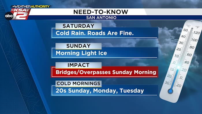
Temperatures will begin to fall Saturday morning and it’ll turn windy. If you live in the Hill Country, ice should begin late Saturday Afternoon, however, in San Antonio it’ll be an intermittent cold rain most of the day. We do not anticipate any ice issues on the roads around San Antonio Saturday.
Roads will be just fine in San Antonio Saturday. But ice is possible in the Hill Country (Copyright 2026 by KSAT – All rights reserved.)
SUNDAY
Temperatures will drop below freezing by early Sunday morning, so that’s when we could see some light icing around Bexar County and San Antonio. It’s best to avoid travel around town Saturday night and Sunday morning.
At least a light ice is possible Sunday morning for most of San Antonio (Copyright 2026 by KSAT – All rights reserved.)
By midday, all precipitation will end, and we may even briefly rise above freezing. However, temperatures will plummet Sunday night with readings in the lower 20s Monday morning.
Monday morning will be the coldest morning around our region. Temps will be in the teens in the Hill Country and low-20s around San Antonio (Copyright 2026 by KSAT – All rights reserved.)
IMPACTS
Because more ice accumulation is expected in the Hill Country, this is where impacts will be greatest. Accumulations of up to 0.25″ should cause travel disruptions and poses a risk for isolated power outages. This kind of ice can cause tree limbs to break and power lines to sag, leading to the risk of power outages.
Only expect minor impacts to bridges and overpasses Sunday morning around San Antonio. More substantial impacts from higher ice accumulation is possible in the Hill Country, though (Copyright 2026 by KSAT – All rights reserved.)
Less accumulation is expected in San Antonio — a glazing to 0.10″. This can still present a danger, with slick spots on bridges and overpasses possible.
BE PREPARED FOR COLD
Expect to be below freezing for at least 24 hours and perhaps even longer, depending on temperatures Sunday afternoon. Sunday, Monday, and Tuesday mornings will be well below freezing.
Now is the time to prepare your home for extended cold: insulate exposed pipes, cover outdoor faucets, make sure your pets will be inside with you this weekend and early next week.
The latest forecast from Your Weather Authority (Copyright 2026 by KSAT – All rights reserved.)Daily Forecast
KSAT meteorologists keep you on top of the ever-changing South Texas weather.
QUICK WEATHER LINKS
Copyright 2026 by KSAT – All rights reserved.