
Current watches and warnings | Submit your weather photos and videos | Closings and delays | TXDOT driving conditions | Lubbock Airport Flights | City of Lubbock updated links
Watch a livestream of road conditions, radar and weather in the player above.
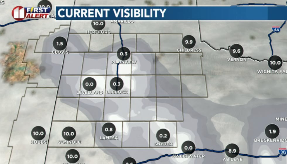
LUBBOCK, Texas (KCBD) – Update 2:58 p.m. – Now that the temperature has dropped to the mid 20s in Lubbock, roads are getting icy. There have already been a few wrecks reported.
Freezing rain and drizzle along with sleet has been falling around Lubbock last hour.
Roads will get worse rest of today, along with showers of sleet and freezing rain increasing. Farther northwest, snow has been reported around Friona.
posted Friday morning – Fog is locally dense across portions of the Caprock this morning, but is already starting to diminish quickly as the arctic cold front moves southward through the forecast area.
As of 8 a.m. the northeast has already cleared out, and we expect this trend to continue as the front pushes through.
A Dense Fog Advisory is not being issued due to the fog being localized and diminishing behind the front.
 KCBD(KCBD)
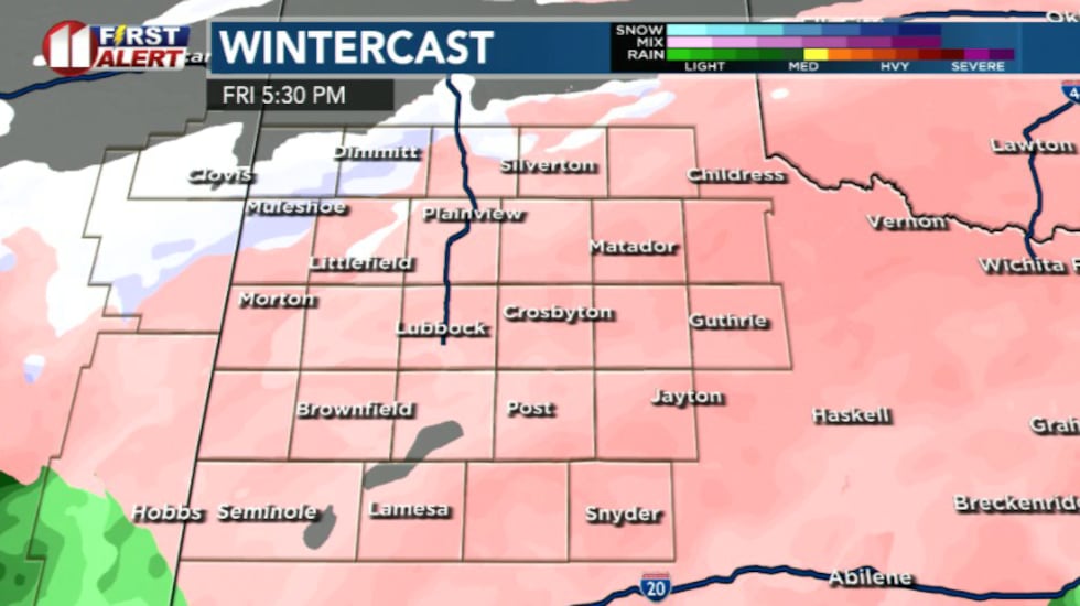
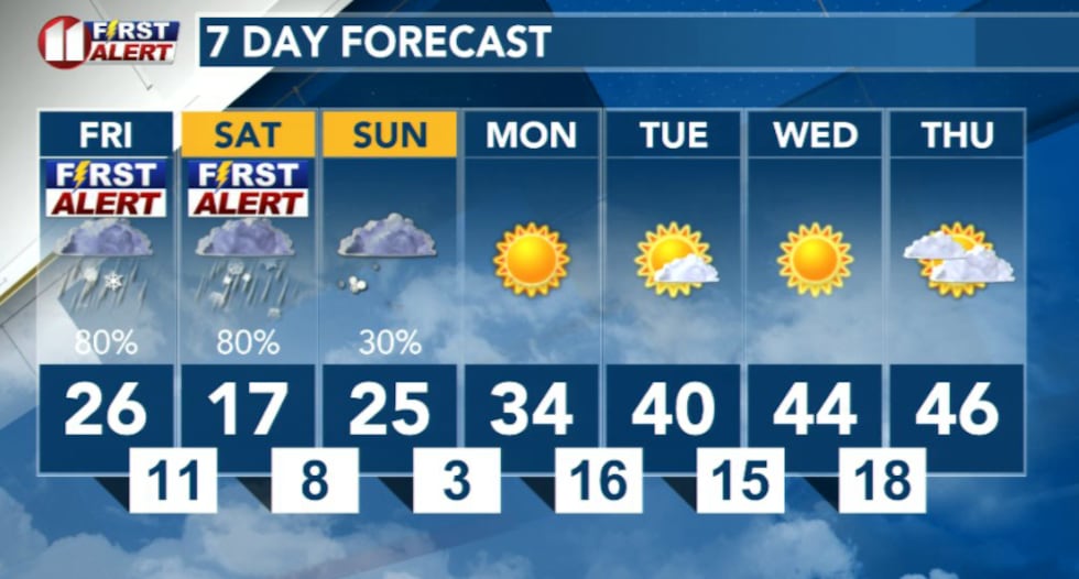
Winter storm conditions will begin Friday with a messy combination of rain, freezing rain and sleet before transitioning to snow Saturday afternoon into Saturday night. Ice accumulation is expected to be most significant Friday night into early Saturday morning, while the heaviest snow will fall Saturday night into early Sunday.
 KCBD(KCBD)
This is a system with multiple precipitation types and the transition between rain, freezing rain, sleet and snow will make conditions particularly dangerous for travelers.
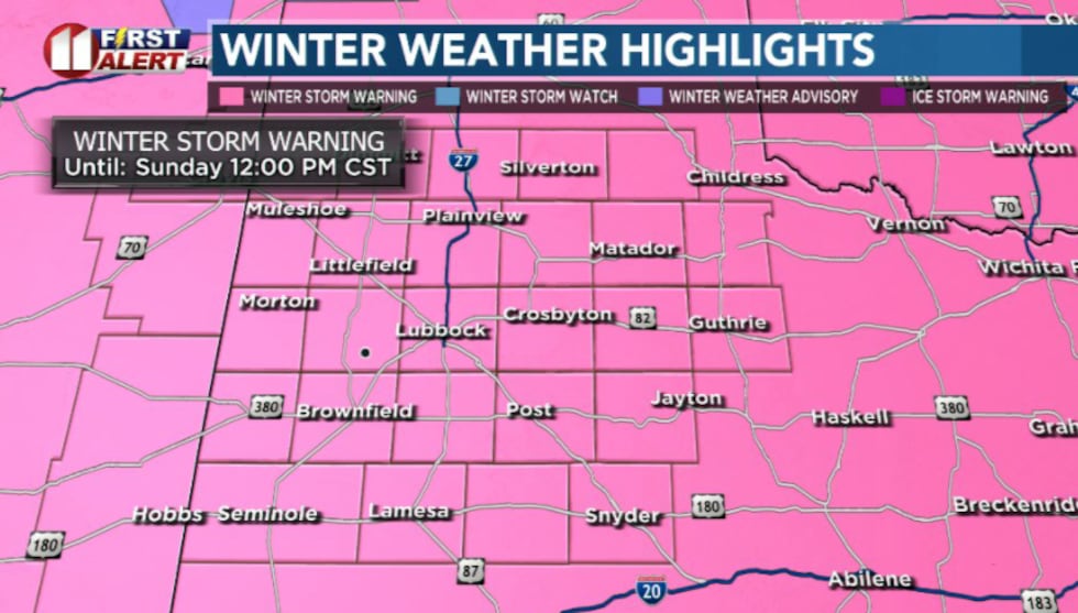
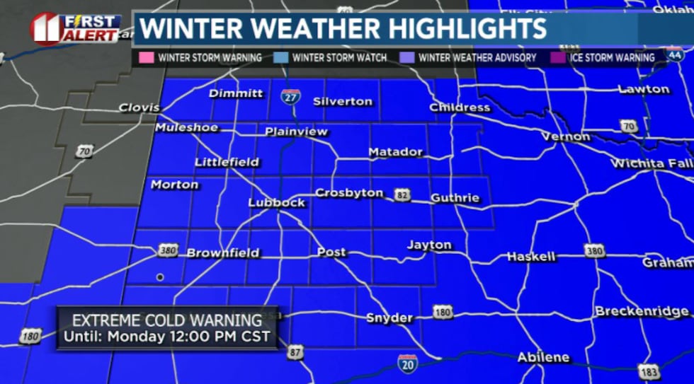
Official Warnings in Effect
Winter Storm Warning: In effect for the entire area from noon Friday through noon Sunday. Impactful snow and ice accumulations are expected across the region this weekend. Snow fall totals may vary, as of this morning Lubbock looks favorable to receive maybe 4 inches of snowfall.
 KCBD(KCBD)
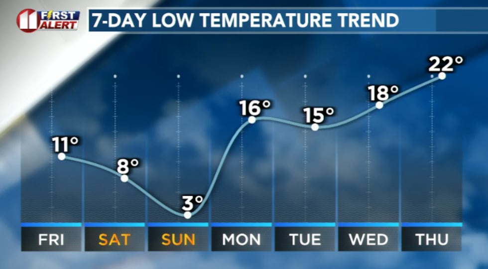
Extreme Cold Warning: In effect for the entire area from late Friday night through Monday morning. Very cold temperatures are expected with morning lows in the single digits on Saturday, Sunday and Monday.
What to Expect
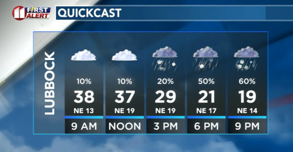
Friday: Precipitation will develop by midday Friday and intensify through the evening hours. Rain will transition to a mix of freezing rain and sleet as temperatures drop below freezing. Ice accumulation of a few hundredths up to one-tenth of an inch is expected, though higher amounts are possible. Most ice accumulations will occur this afternoon through Saturday morning.
 KCBD(KCBD)
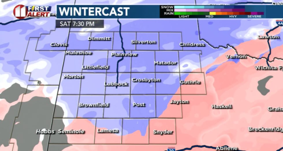
Saturday: A brief lull in precipitation is expected early Saturday morning before conditions deteriorate again. Snow will become the dominant precipitation type Saturday afternoon into Saturday night, with the heaviest accumulations expected overnight into early Sunday.
 KCBD(KCBD)Extreme Cold Follows
The artic front will also bring dangerously cold temperatures through the weekend. Wind chills are expected to plunge to as low as 15 degrees below zero each morning, with Saturday morning wind chills ranging from 0 to nearly minus 15 degrees.
 KCBD(KCBD)
Temperatures Friday will reach the 30s across higher elevations and the 40s across much of the region, with highs occurring before noon. Overnight lows will drop into the single digits to around 12 degrees on Saturday, Sunday and Monday mornings.
 KCBD(KCBD)
This will be the first time this winter season we experience sub-zero wind chills. The extreme cold poses a serious risk for frostbite and hypothermia.
Travel Safety
Travel conditions will be very dangerous this weekend across the region, and travel is strongly discouraged. The combination of icy roads and extreme cold makes any travel particularly hazardous. If you must travel, reduce speed, increase following distance and be prepared for sudden stops.
Protecting Yourself from Extreme Cold
Reduce time outdoors, and take proper precautions to avoid frostbite and hypothermia if you do need to be outside.
Dress appropriately for extreme cold by wearing multiple layers of loose-fitting, lightweight clothing. Cover all exposed skin, including ears, nose, mouth and chin. Wear a hat, gloves and insulated, waterproof boots. Change out of wet clothing immediately and limit outdoor exposure to short periods only.
Frostbite can develop on exposed skin in as little as 30 minutes when wind chills are below zero. Hypothermia can set in quickly in extreme cold conditions.
 KCBD(KCBD)
Copyright 2026 KCBD. All rights reserved.