
Current watches and warnings | Submit your weather photos and videos | Closings and delays | TXDOT driving conditions | Lubbock Airport Flights | City of Lubbock updated links
Watch a livestream of road conditions, radar and weather in the player above.
LUBBOCK, Texas (KCBD) – Update 5:40 p.m. – The bulk of precipitation is beginning to move east of the LBK city limits, we will see a slight lull until more precipitation moves in this evening. Areas off the Caprock will continue to see on and off wintry precipitation for the next few hours.
Conditions will continue to become hazardous through the evening and overnight period.
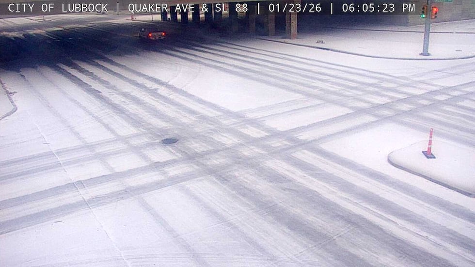 Quaker Ave & SE 88 at 6:05 pm(City of Lubbock)
Road conditions are deteriorating quickly, with multiple accidents being reported due to the slick conditions.
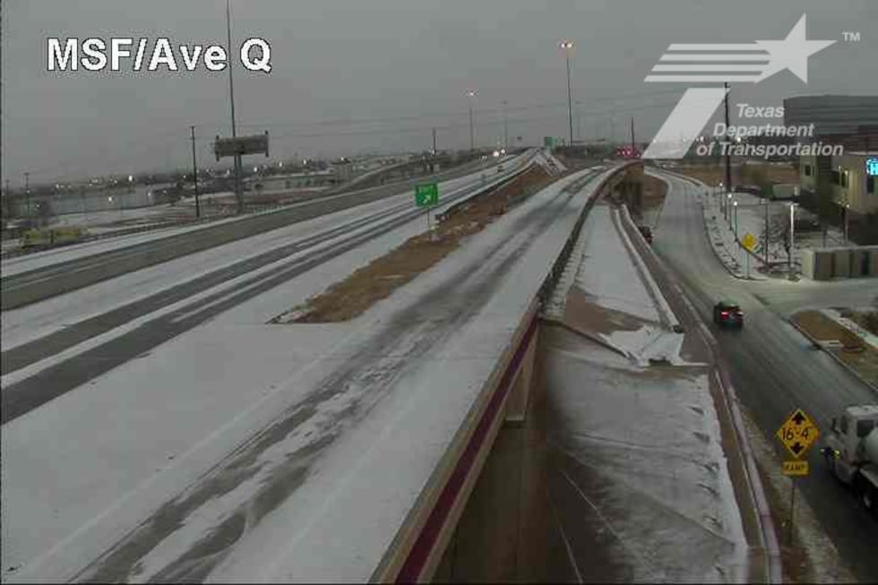 Marsha Sharp Fwy at Ave Q(Texas Department of Transportation)
Along with showers of sleet and freezing rain increasing. Farther northwest, snow has been reported around Friona.
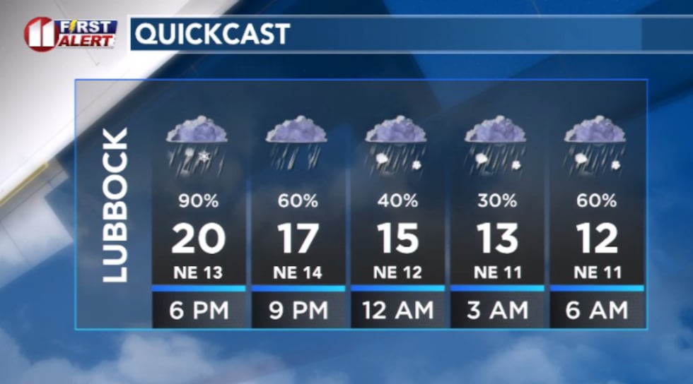 Quick cast showing overnight temperatures dropping fast(KCBD)
This is a system with various precipitation types and the transition between rain, freezing rain, sleet and snow will make conditions particularly dangerous for travelers.
By this evening, sleet becomes the bigger problem. Keep in mind, that sleet bounces, compacts, and turns into a dense, icy layer that strips traction from roads. Travel conditions will steadily deteriorate through the evening hours, even if precipitation doesn’t look intense at any given moment.
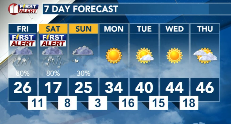
Winter storm conditions continue through Sunday with a messy combination of rain, freezing rain and sleet before transitioning to snow Saturday afternoon into Saturday night. Ice accumulation is expected to be most significant Friday night into early Saturday morning, while the heaviest snow will fall Saturday night into early Sunday.
 KCBD(KCBD)
This is a system with various precipitation types and the transition between rain, freezing rain, sleet and snow will make conditions particularly dangerous for travelers.
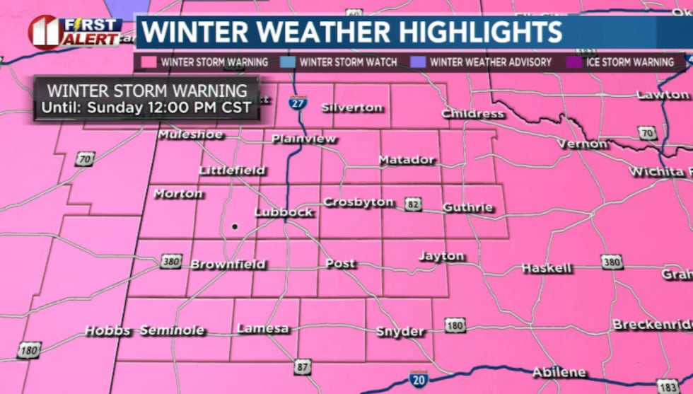
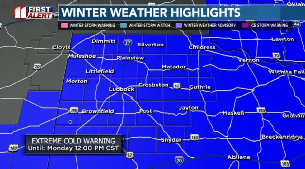
Official Warnings in Effect
Winter Storm Warning: In effect for the entire area from noon Friday through noon Sunday. Impactful snow and ice accumulations are expected across the region this weekend. Snow fall totals may vary, as of this morning Lubbock looks favorable to receive maybe 4 inches of snowfall.
 KCBD(KCBD)
Extreme Cold Warning: In effect for the entire area from late Friday night through Monday morning. Very cold temperatures are expected with morning lows in the single digits on Saturday, Sunday and Monday.
What to Expect
Friday: Conditions will continue to deteriorate steadily. Temperatures continue to fall and precipitation continues to spread across the area.
The highest icing risk is this afternoon into early tonight. Ice accumulation of a few hundredths up to one-tenth of an inch is expected, though higher amounts are possible. Northeast winds will help ice stick to north-facing surfaces (bridges, overpasses, signs)
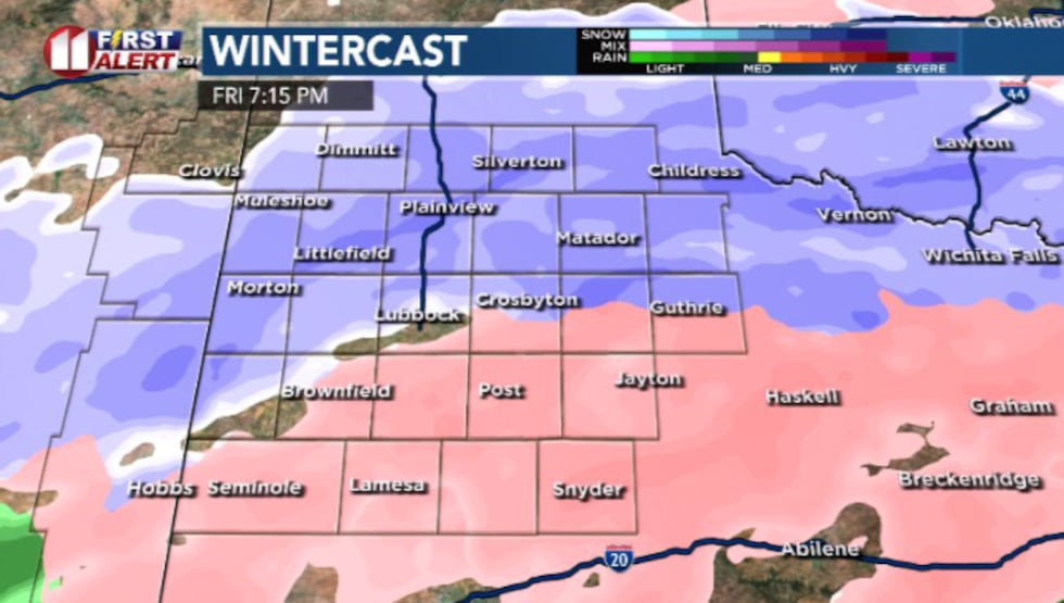 Friday 7:15p(KCBD)
Freezing rain and sleet will continue and intensify through the evening hours.
Friday Overnight: Sleet becomes the dominant precipitation type with occasional freezing rain or snow mixed in. Temperatures fall into the single digits and low teens, locking in everything that’s already fallen.
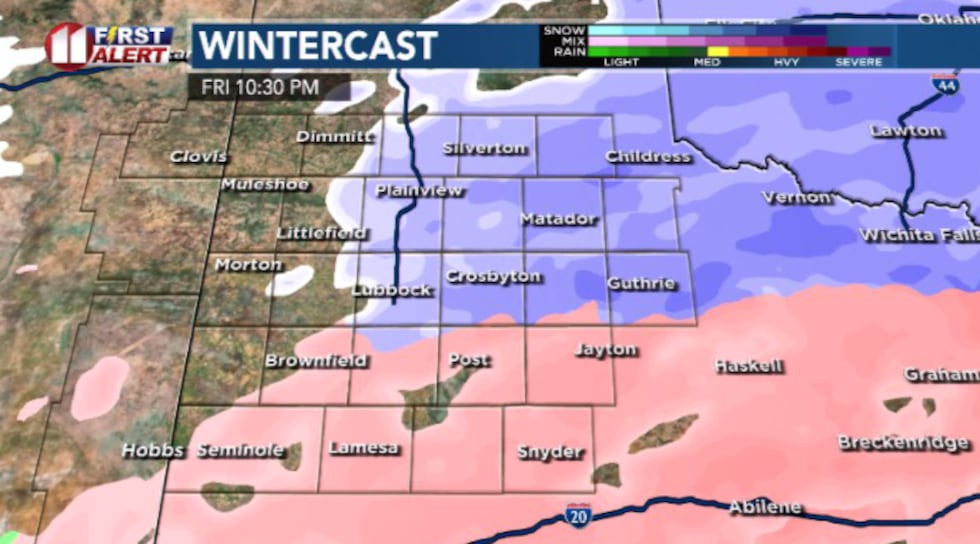 Friday 10:30 pm(KCBD)
Roads become icy and uneven, and even treated surfaces may struggle to improve. Wind chills near or below zero add another layer of danger.
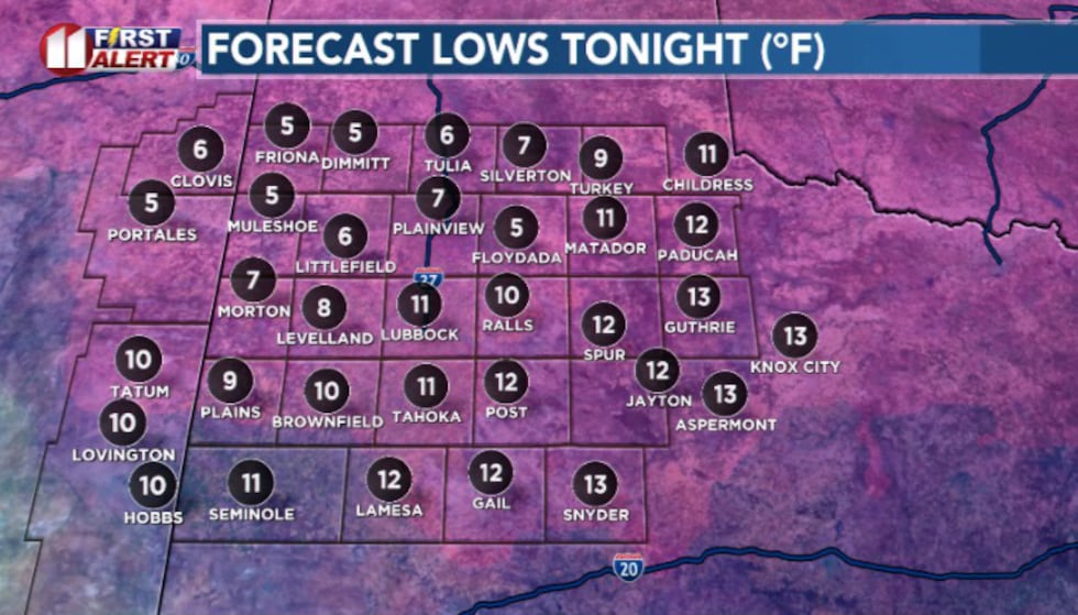 Lows tonight(KCBD)
Saturday: A brief lull in precipitation is expected mid-morning before conditions deteriorate again. Do not mistake this for an improvement in conditions. Temperatures will stay locked in the teens and roads will remain icy.
By Saturday afternoon, precipitation redevelops as a mix of sleet and snow, and accumulation resumes.
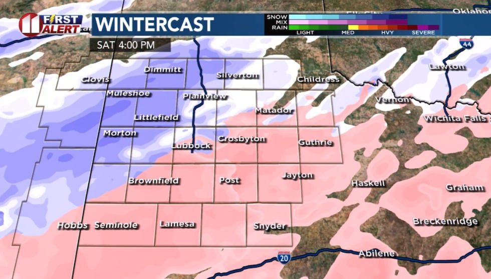 Saturday 4 pm(KCBD)
Saturday evening is expected to be the most impactful window of the entire storm period. Precipitation transitions to all snow, and heavier bands are possible with the heaviest accumulations expected overnight into early Sunday.
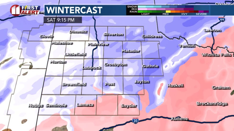 Saturday 9:15 pm(KCBD)
Snow can accumulate quickly, covering already slick roads and making travel nearly impossible, especially outside city limits.
Travel during Saturday night into early Sunday morning is strongly discouraged.
Extreme Cold Follows
The arctic front will also bring dangerously cold temperatures through the weekend. Wind chills are expected to plunge to as low as 15 degrees below zero each morning, with Saturday morning wind chills ranging from 0 to nearly minus 15 degrees.
Friday night lows will drop into the single digits to around 12 degrees on Saturday, Sunday and Monday mornings.
This will be the first time this winter season we experience sub-zero wind chills. The extreme cold poses a serious risk for frostbite and hypothermia especially for vulnerable populations.
Travel Safety
Travel conditions will be very dangerous this weekend across the region, and travel is strongly discouraged. The combination of icy roads and extreme cold makes any travel particularly hazardous. If you must travel, reduce speed, increase following distance and be prepared for sudden stops.
Keep in mind, during these freezing tempreatuers vehicles are more likely to fail to start, stall, and have a reduced battery life. If your care breaks down, cold exposure becomes a serious risk very quickly.
Protecting Yourself from Extreme Cold
Reduce time outdoors, and take proper precautions to avoid frostbite and hypothermia if you do need to be outside.
Dress appropriately for extreme cold by wearing multiple layers of loose-fitting, lightweight clothing. Cover all exposed skin, including ears, nose, mouth and chin. Wear a hat, gloves and insulated, waterproof boots. Change out of wet clothing immediately and limit outdoor exposure to short periods only.
Frostbite can develop on exposed skin in as little as 30 minutes when wind chills are below zero. Hypothermia can set in quickly in extreme cold conditions.
 KCBD(KCBD)
Copyright 2026 KCBD. All rights reserved.