
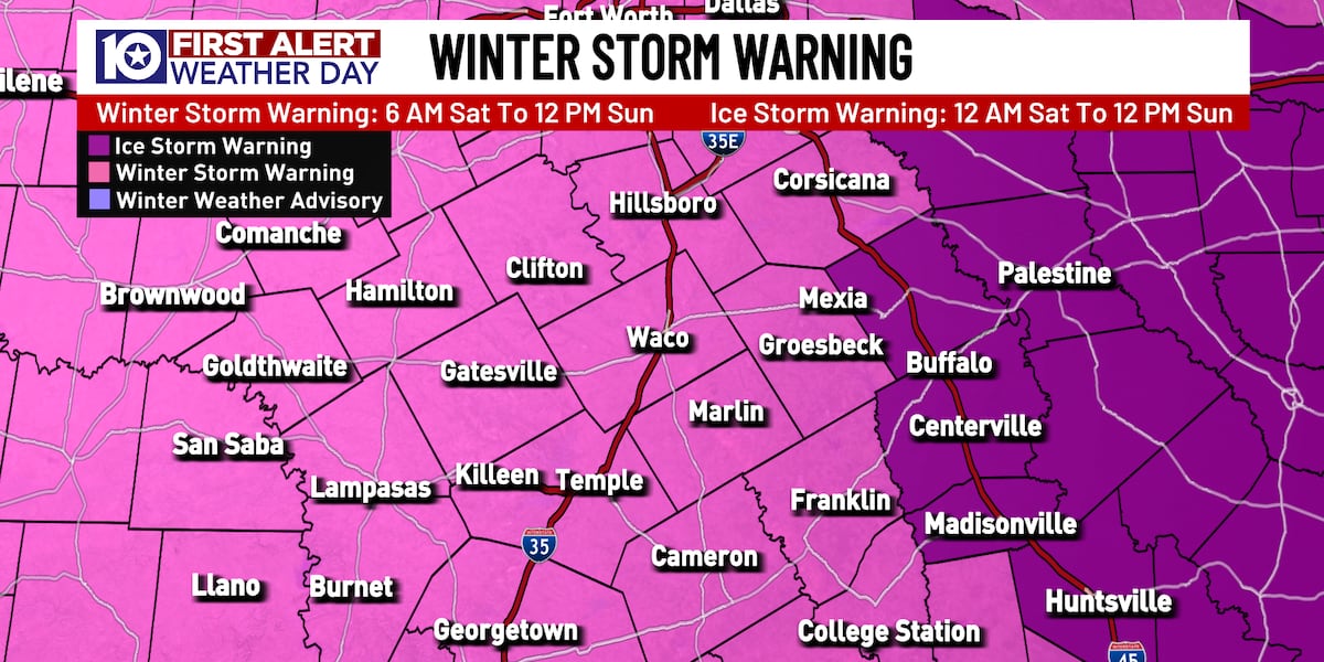
Latest Watch and Warning Information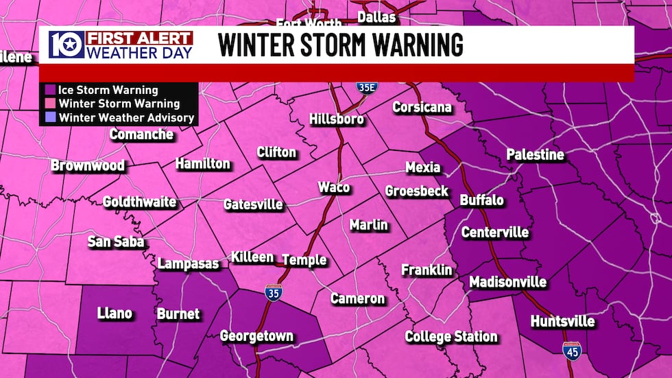 A Winter Storm Warning and an Ice Storm Warning are in effect for parts of Central Texas.(KWTX)
A WINTER STORM WARNING has been issued for most of Central Texas from 6 AM Saturday through noon Sunday. As of Friday afternoon, this watch includes the majority of the region with the warning time running longer to the north.
An ICE STORM WARNING has been issued for Freestone, Leon, and Madison counties in eastern Central Texas, and for Llano, Burnet, and Williamson counties in southern Central Texas. These warnings are in effect until noon on Sunday.
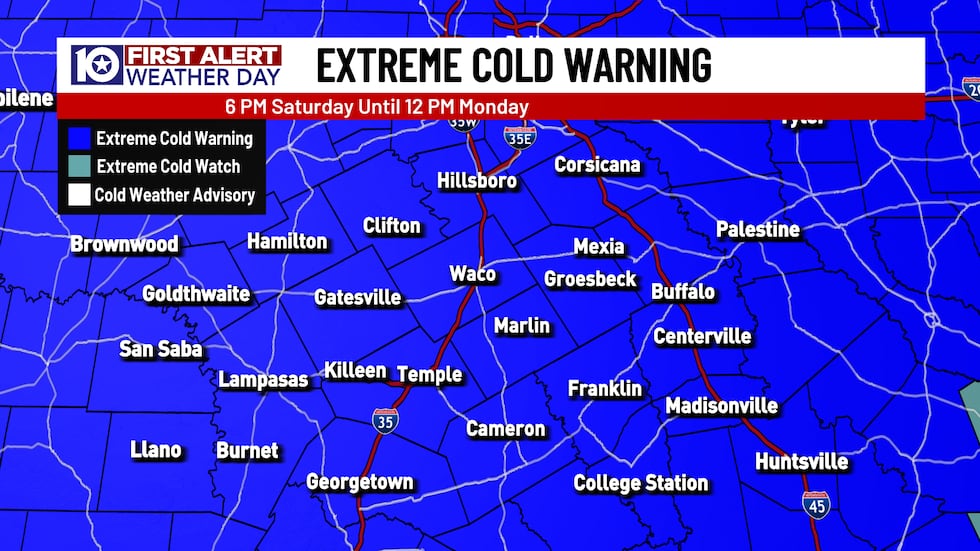 An Extreme Cold Warning is in effect for Central Texas from 6 PM Saturday to 12 PM Monday.(KWTX)
An EXTREME COLD WARNING Has been issued for Central Texas from Saturday evening through Monday morning, as dangerously cold wind chills are expected. Wind chills in the single digits and teens are likely, and we can’t rule out a few areas seeing wind chills near zero or even below zero degrees on Sunday morning. Earlier today this warning was extended into the Brazos Valley and into East Texas and now covers nearly the entire state.
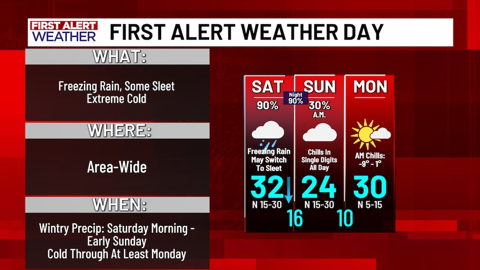 First Alert Weather Days have been issued for Saturday, Sunday, and Monday.(KWTX)
We have issued FIRST ALERT WEATHER DAYS FOR SATURDAY, SUNDAY, AND MONDAY due to the dangerous impacts we could see from this weekend’s winter storm. The general consensus is that Central Texas will be hit hard by a mix of freezing rain and sleet with extreme cold to follow.
If you would like to know what the differences are between the main types of winter precipitation and what they really are (freezing rain, sleet, and snow), click the link to the story here.
Freezing rain and some sleet expected Saturday, Saturday night
We had a few off and on bands of freezing rain and sleet work through Central Texas throughout the day Saturday. A few if these bands were rather strong, with one storm that moved from the Lampasas area up towards Hillsboro producing thunder sleet!
The most widespread band of wintry precipitation will move through Central Texas during the overnight hours. Most of precipitation will be sleet, but some freezing snow is possible. The best potential for freezing rain will be across our southeastern counties.
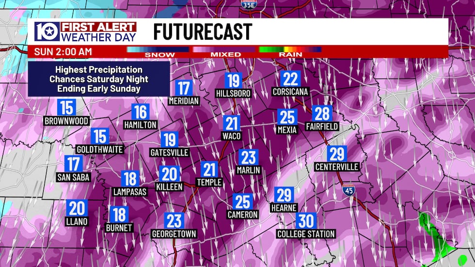 Around midnight and into the early AM is when we will see the heaviest of the wintry mix. Ideally this will be more sleet than freezing rain but if it stays freezing rain road conditions will go from bad to worse.(KWTX)
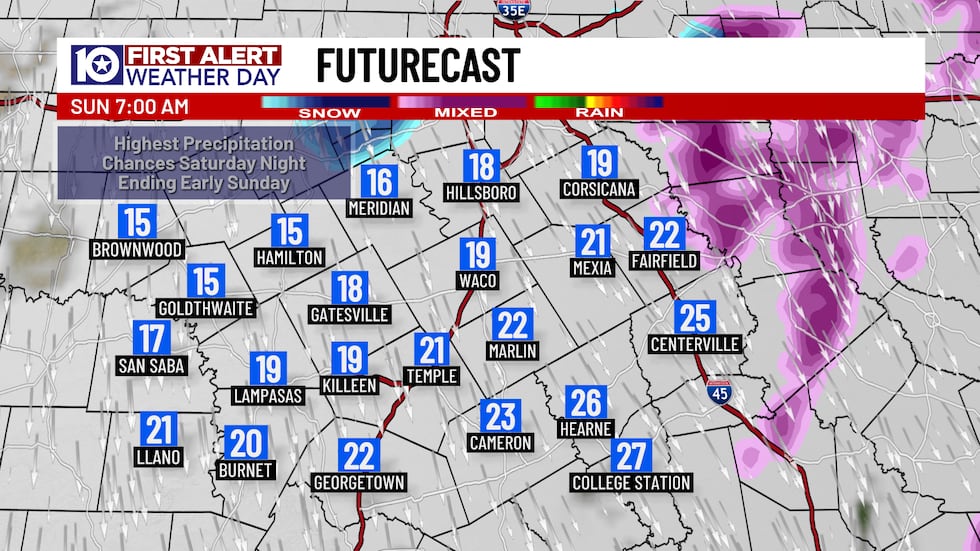 By Sunday morning we will be mostly out of the precipitation, but frigid temperatures and cloud cover blocking out the sun will not allow anything to melt.(KWTX)
The majority of the wintry precipitation should be out of our area by sunrise Sunday.
Sunday & Monday Are The COLD Days
As the storm moves out, dry and cold air will take its place Sunday. Sunshine will be in no short supply once morning clouds clear, but temperatures will be very cold. Sunday’s morning lows are expected to be in the low 10s and wind chills will likely be near or below zero! Wind chills will climb into the single during the afternoon, but highs will only warm into the mid-20s.
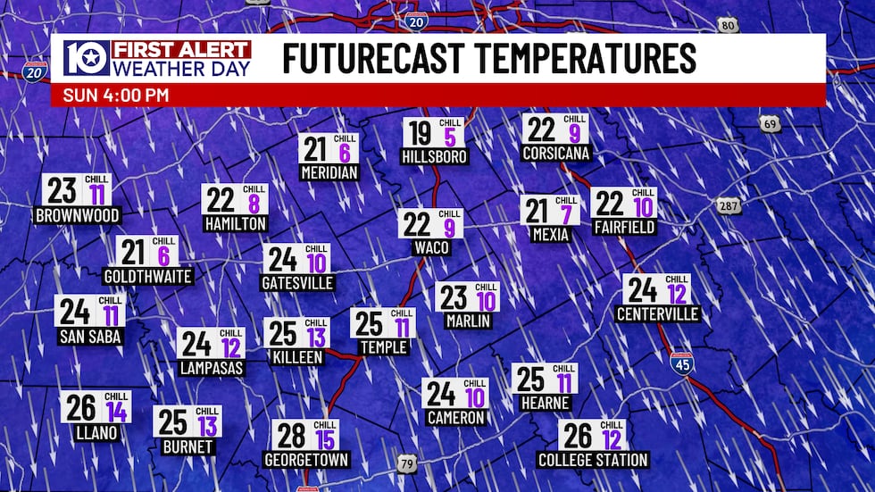 We will be staying below freezing all through the day on Sunday so the ice will not have any opportunity to melt. Winds could gust as high as 30 MPH which will keep wind chills down in the teens and single digits.(KWTX)
Since we’re staying below freezing all Sunday long, some slight ice melting will take place IF sunshine returns, but roads should remain icy. Better traveled and treated roadways may fare better, but any water that’s left on roads after sunset will refreeze Sunday night. Black ice is a possibility on any roadways that sees ice refreeze Sunday night, so roads may “look” clear Monday morning but may very well be slick!
We’re again kicking off the day Monday with temperatures near around 10° with wind chills between -10° and 0°. Depending on how much ice remains on the ground, some spots will warm slightly above freezing late-day, but some spots will stay below freezing all day long. Sunshine will again cause some melting, but anything left refreezes again Monday after sunset.
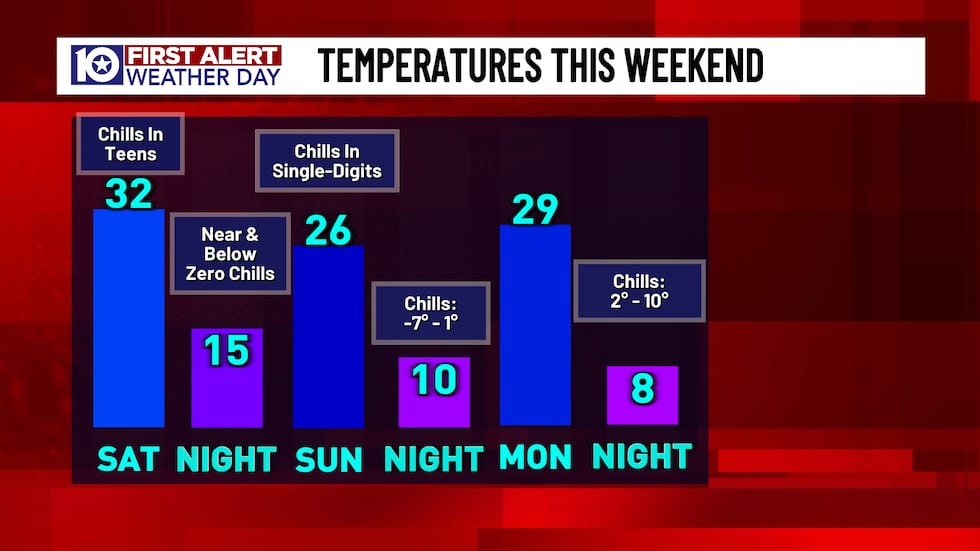 Temperatures are going to plummet starting tonight, and then even more once the precipitation moves out. With drier air moving in on Sunday, overnight temperature will get down into the single digits and wind chills will likely get below zero.(KWTX)
Thankfully, by Tuesday, temperatures are expected to “warm up” into the low teens in the morning with wind chill above zero! We’ll warm above freezing area wide mid-to-late morning. Warmer-than-freezing temperatures with highs in the 40s under sunny skies should cause most of, if not all, lingering ice to melt. Isolated slick spots could be possible Wednesday morning, but Tuesday’s the big thawing out day.
What To Prepare For
We’re forecasting around a quarter-inch of ice for the entire area, but ice totals will be lower, closer to or hopefully below a quarter-inch, if you live closer to Austin. If you live closer to the Metroplex, ice totals may approach or even exceed a half-inch!
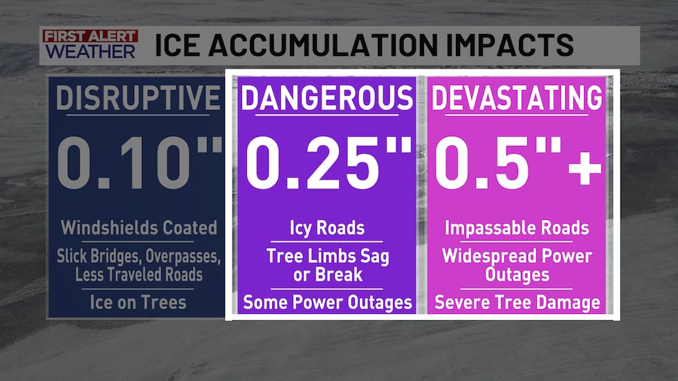 Since it’s looking more likely that sleet will be the dominant precipitation type, ice accumulation may drop! Sleet by itself WILL produce widespread icy roadways, but sleet is usually easier on power lines and tree branches. We are expecting power outages with at least a quarter-inch of ice coming. If ice totals approach or exceed a half-inch, widespread power outages become likely along with severe tree damage.(KWTX)
At the bare minimum, we’re expecting at least 60 hours below freezing with upwards of 84 hours (roughly from pre-dawn Saturday to Tuesday morning) with sub-freezing temperatures. Protect your pipes! Make sure any outdoor exposed piping is well insulated and open cabinets under sinks in order to keep warm air flowing.
Keep an array of jackets and blankets handy in case the power goes out. Ice storms are notorious for bringing down power lines and tree branches, so power may be knocked out until that infrastructure is repaired. You can use a space heater to keep an area warm, but keep that space heater far from any flammable items like drapes!
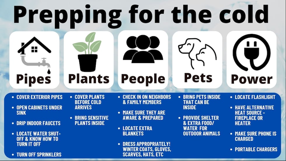 Prepping For The Cold(KWTX)
Road conditions will deteriorate progressively through Saturday and Saturday night as waves of freezing rain and sleet move through. Expect that you will not be able to travel on Saturday and Sunday too! Frequently traveled and any treated roadways may be slick, but travelling short distances should be possible so long as you drive slowly!
It’s a good idea to get some easy-to-make food in case you do lose power for an extended period of time, but life will return to normal quickly. Make sure you have at least 3 days worth of water, food, and medication on-hand. It’s a great idea to have food that doesn’t need to be cooked in case you lose power.
As this weekend draws closer, keep up with the forecast! You can download our FREE KWTX Weather App! Search KWTX Weather in the App Store or Play Store.
Copyright 2025 KWTX. All rights reserved.