

NWS Houston/Galveston
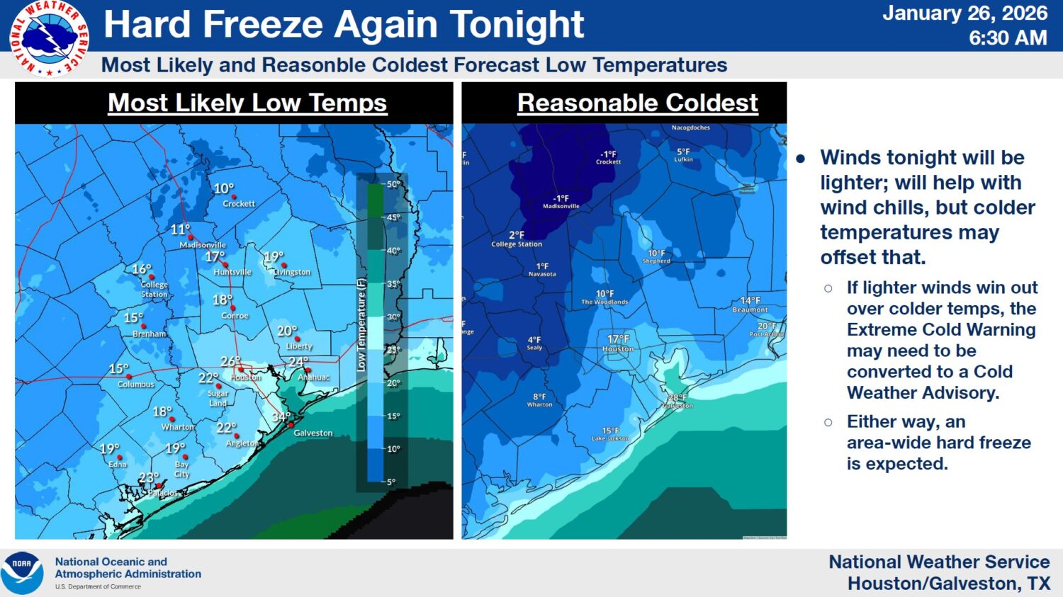
A hard freeze warning for Monday night from the National Weather Service Houston/Galveston Office.
Temperatures were in the 20s on Monday morning across the Houston area, where an extreme cold warning will remain in effect until midday Tuesday.
The region will briefly thaw Monday afternoon, when temperatures are expected to rise into the upper 30s or low 40s, followed by another hard freeze Monday night, according to the National Weather Service. A low of 26 degrees is forecast for Monday night into Tuesday morning.
RELATED: ‘We cannot let our guard down’: Freezing weather hits Houston area
Sign up for the Hello, Houston! daily newsletter to get local reports like this delivered directly to your inbox.
Matt Moreland, the meteorologist in charge at the weather service’s Houston/Galveston office, said Monday during an appearance on Houston Matters that some of the ice that emerged early Sunday may have dissipated over the course of the day.
“Temperatures yesterday were actually in the mid-20s all through the afternoon, which for Houston, mid-20s in the afternoon is among the very coldest days that you’re going to see,” he said. “But ice will evaporate. It tends to stick more on bridges and overpasses. … Even in Houston, you could still have some spotty ice on bridges and overpasses in a few spots.”
RELATED: These Houston-area warming centers will be open during the winter storm
About 1,400 homes and businesses in the Houston area were without electricity as of about 10 a.m. Monday, according to CenterPoint Energy, which supplies electricity to much of the region.
RELATED: Harris County polling locations closed Sunday and Monday because of winter weather
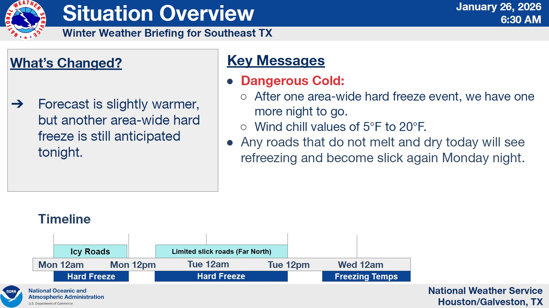
The NWS forecasts that light freezes will persist throughout the week in outlying areas.
NWS Houston/Galveston
A Monday morning weather updated from the National Weather Service Houston/Galveston Office.
The extreme cold warning is set to expire at noon Tuesday, but lows for Tuesday night are expected to hover around freezing, especially north of Interstate 10.
RELATED: Icy roads and canceled flights: Winter weather halts Houston’s Monday morning travel
According to the NWS, hazardous travel conditions are expected to persist through Monday morning as some icy areas have not yet reached above-freezing temperatures.
The NWS is still asking residents to remain vigilant and protect the four Ps: people, pets, pipes, and plants.
RELATED: Houston-area school districts announce Monday closures ahead of incoming winter storm
Moreland said temperatures will slowly rise throughout the week, but that another cold front may reach the area on Thursday into Friday.
“This is still several days out [and] we’re watching the trends,” Moreland said. “On the positive side, we’re not seeing a wintry precipitation signal with the system right now. … We do see the potential for another couple of really cold nights this weekend, but Friday night and Saturday night, we’re looking at the potential for freezing temps in Houston and possibly a hard freeze.”