
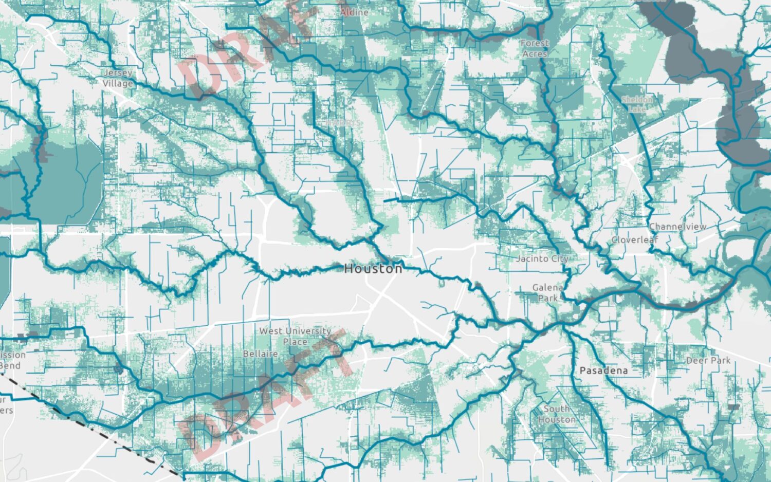
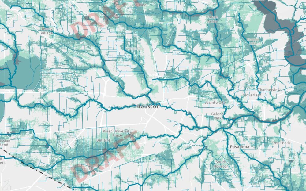
Harris County Flood Control District
This draft flood risk map shows proposed flood-risk levels for the Houston area. Areas shaded light green are slated for a 500-year floodplain designation by FEMA, while darker areas represent a 100-year floodplain designation.
A newly proposed Harris County flood zone map adds heightened flood risks for households across the Houston area.
A draft of the Federal Emergency Management Agency’s new and long-awaited flood risk map will likely go through several variations before final approval. The map — which was quietly released on the agency’s website two weeks ago and intended for technical reviews by floodplain administrators — marks a major revision in Harris County’s flood risk zones that haven’t seen a comprehensive update in nearly 20 years.
Under the proposed map — which will influence insurance coverages as well as local development rules — the 100-year and 500-year floodplains widely expanded in south Houston, while some areas in southwest Houston saw a reduced flood risk. Both floodplains appeared to spread in northeast Harris County near Lake Houston under the proposal.
Sign up for the Hello, Houston! daily newsletter to get local reports like this delivered directly to your inbox.
Jim Blackburn, an environmental law professor at Rice University, said that a reevaluation of rainfall rates is one of the most significant developments since the county’s previous flood maps were released in 2007. The federal agency’s newly proposed map reflects about a 30% increase in rainfall rates.
The 2007 maps — which will continue to be used until the proposal is evaluated by floodplain administrators and county officials — used a calculation that properties in 100-year floodplains could flood with 13 inches of rain in 24 hours. The new maps assume about 17 inches of rain in 24 hours in those floodplains.
“That increase, we saw it with Allison, we saw it with Harvey, we saw it with Imelda … flooding that we had all in the last 20 years,” Blackburn said. “So the numbers are going up. With bigger rains, you’re going to have bigger floodplains.”
The Harris County Flood Control District, which works with FEMA to provide technical information to inform updated flood risk maps, on Monday published a user-friendly version of the proposed map allowing residents to compare their household’s potential risk. Before the proposed map was released, the flood control district updated Harris County’s topography and mapped an additional 400 miles of channels in the county, which includes Houston.
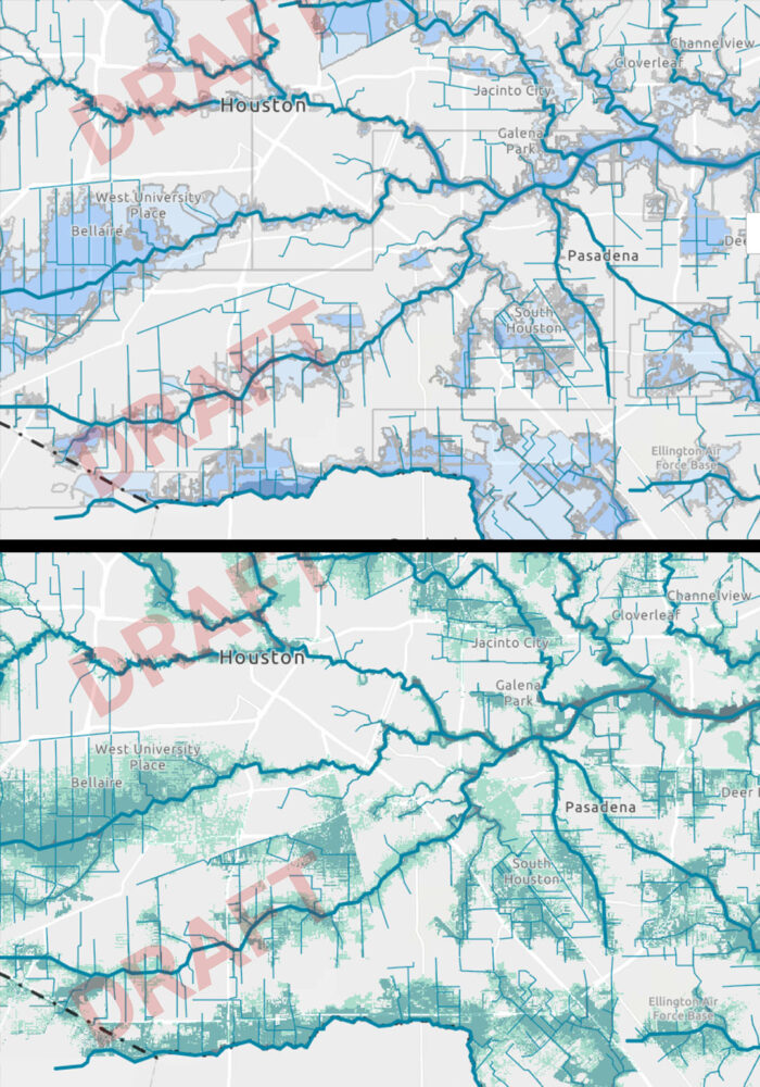
Harris County Flood Control District
The top image shows southeast Houston on Harris County’s existing flood risk map, while the bottom image reveals the Federal Emergency Management Agency’s proposed flood risk map.
Emily Woodell, a spokesperson for the flood control district, said some of the changes reflect the progress of several flood mitigation projects. Early results show areas where flood risk has decreased because of investments made through the county’s 2018 flood bond program, she said.
“That means in some neighborhoods, families who once faced repeated flooding are now seeing measurable reductions in risk,” Woodell said. “There is more work to do, but we know these projects are making a difference, and hundreds of millions of dollars in additional construction is set to begin this year.”
RELATED: Harris County faces $410 million funding shortfall on post-Harvey flood projects
The county’s 34 floodplain administrators will work with the federal agency on any revisions to the proposed map, and a formal appeal process and public comment period will take place before the deadline to adopt new changes.
Tina Petersen, the executive director of the flood control district, said that deadline would likely be years from now. Following a revelation that 68% of all the structures in Harris County that flooded during Hurricane Harvey in 2017 were outside of the 100-year floodplain, there was a multi-jurisdiction push to update flood maps, she said.
“We know that when we have access to better, more accurate information, we can have better decision making on behalf of our community, on behalf of our local governments, and for emergency preparedness,” she said.
The flood control district plans to host informal webinars to discuss the proposed changes. Harris County residents can search here for their home address on the flood control district’s interactive map of FEMA’s proposed changes.