
Richardson is working to reduce roadway deaths and serious injuries, according to a presentation on the Safer Streets Richardson plan at the Feb. 16 City Council meeting.
Mobility program manager Daniel Herrig presented an update on the safety action plan, including high-crash locations that city staff identified as places to improve safety.
Some context
The Safer Streets Richardson plan is a safety action plan funded through the U.S. Department of Transportation’s Safe Streets and Roads for All grant program. It focuses on reducing transportation-related fatalities and serious injuries through data-driven and collaborative methods.
Richardson is one of a few cities in the Dallas-Fort Worth area, including McKinney and Frisco, that are currently developing a plan like this. Herrig said Richardson’s goal is to reduce roadway deaths and serious injuries by 50% by 2025.
Herrig said the project is finishing up its first phase, which was composed of public engagement, collaboration with stakeholders and safety analysis.
The details
The city conducted a community survey from Aug. 1-Oct. 15, and Herrig said common themes in the responses included speeding and reckless driving, stop sign and red-light violations and pedestrian and cyclist safety.
Staff used police crash report data to analyze crash locations and contributing factors in order to identify high-injury locations and prioritize mitigation projects.
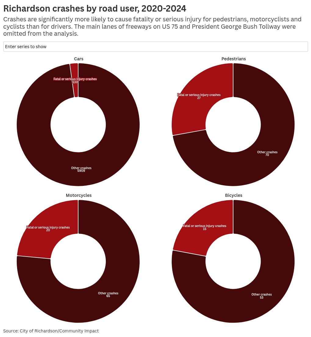
From 2020-2024, there were 6,292 total crashes in Richardson, 195 of which were fatal or serious injury crashes. The analysis also found that crashes were more likely to cause fatality or serious injury for pedestrians, motorcyclists and cyclists than for drivers.
The main lanes of freeways on US 75 and President George Bush Tollway were omitted from the analysis because the city does not have control of those roads, Herrig said.
The approach
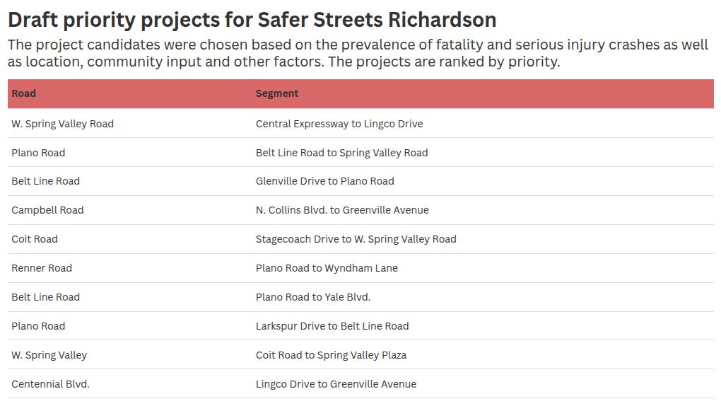
Most crashes happened on arterial roads, which are major roadways with higher speed limits and more traffic, Herrig said. City staff developed a “high-injury network” to map the roads that experience the highest rates of serious crashes. They found that 63% of all fatal and serious injury crashes happen on just 6% of Richardson’s roadway network.
Many of these roads are near commercial activity and have a mix of users every day.
“It’s where you have the most exposure because you have so many vehicle trips on those corridors,” Herrig said. “It’s also where you have the most risk, where you have higher speeds.”
Based on the roads identified in the high-injury network, Herrig said the team narrowed down priority road segments and intersections for targeted projects to improve safety.
In the next phase of the project, Herrig said the team will develop concept plans for the individual projects, analyzing the crash history of each area to determine what safety countermeasures might be needed.
The countermeasures could range from simpler improvements such as changing signal timing, signs or pavement markings to modifying medians, infrastructure and road maintenance.
What they’re saying
Council member Arefin Shamsul said the crash data and analysis provided by the project can help council take safety into account when they make development decisions in the future.
“This will help council make decisions, especially on the sidewalks, intersections [and] new developments, not just because of an argument or presentation from the developer, but from data-driven information,” Shamsul said.
Mayor Amir Omar expressed concern that the goal of a 50% decrease in fatal and serious injury crashes by 2050 is based on raw numbers rather than a per capita decrease. Growth estimates in Richardson between now and 2050 suggest that there will be a lot more cars on the road in the future and therefore more opportunities for accidents, he said.
“Another thing I’m curious about is whether or not in some ways we’re working against the 50 by 50 [goal] when we add more bike lanes,” Omar said. “We want people to cycle more, but more bikes on the streets could inherently mean potentially more bicycle accidents.”
Herrig said that more cyclists on the road could actually work to improve safety overall, because drivers may become more aware of cyclists and more cognizant of bike lanes.
“If you start expecting to see cyclists more, your drivers are going to behave a little differently,” Herrig said.
What’s next
Herrig said the full draft plan will be presented to council by summer. The individual concept plans will be used to secure future funding opportunities and partnerships for the projects.
Herrig said the city also plans to implement a demonstration pilot project funded by the federal grant that will test a new traffic signal preemption system near Fire Station No. 1 aimed at reducing emergency response times and improving traffic flow.