
LUBBOCK, Texas (KCBD) – For our viewers and readers in the Lubbock and West Texas area, a heads up on the wind. The gusty weather will continue through Friday. That will be followed by much less wind, but also much less warmth, this weekend as temperatures dip below average.
Gusty Tonight
Southwesterly winds will average around 10 to 20 mph tonight. Gusts up to 35 mph are likely.
 Mostly fair but gusty and chilly Wednesday night.(KCBD First Alert)
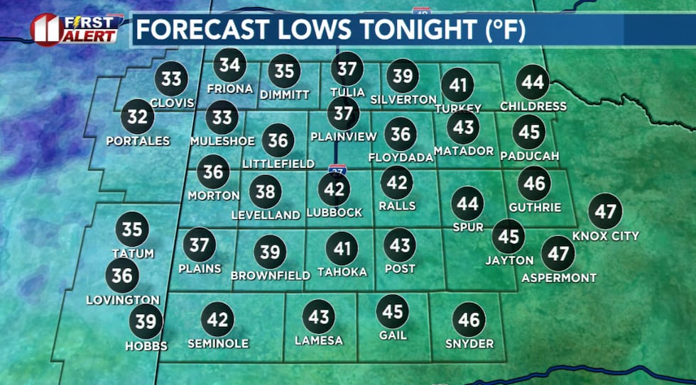
Tonight otherwise clear and chilly. That said, low temperatures will end up about 10 degrees above average for this point in February.
Winds and Fire Danger
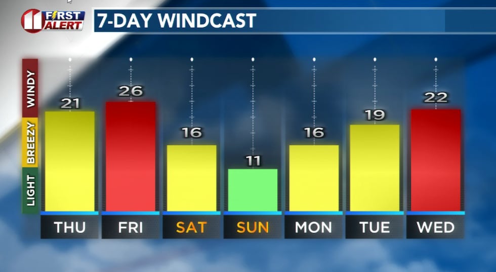
The wind will continue Thursday through Friday. Winds tomorrow are expected to average around 15 to 25 mph with gusts around 35 mph. That’s a little below Wednesday’s peak winds.
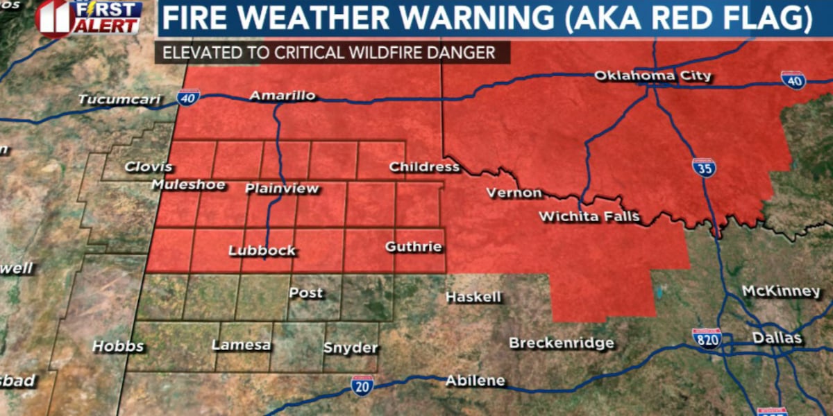
 A Fire Weather (aka Red Flag) Warning will be in effect Thursday critical grassland fire danger from late Thursday morning to early Thursday evening.(KCBD First Alert)
There may be areas of low visibility in blowing dust, especially in areas outside of town and near open fields. Of course, anytime it is windy in West Texas outdoor burning and other activity which may lead to a fire should be avoided.
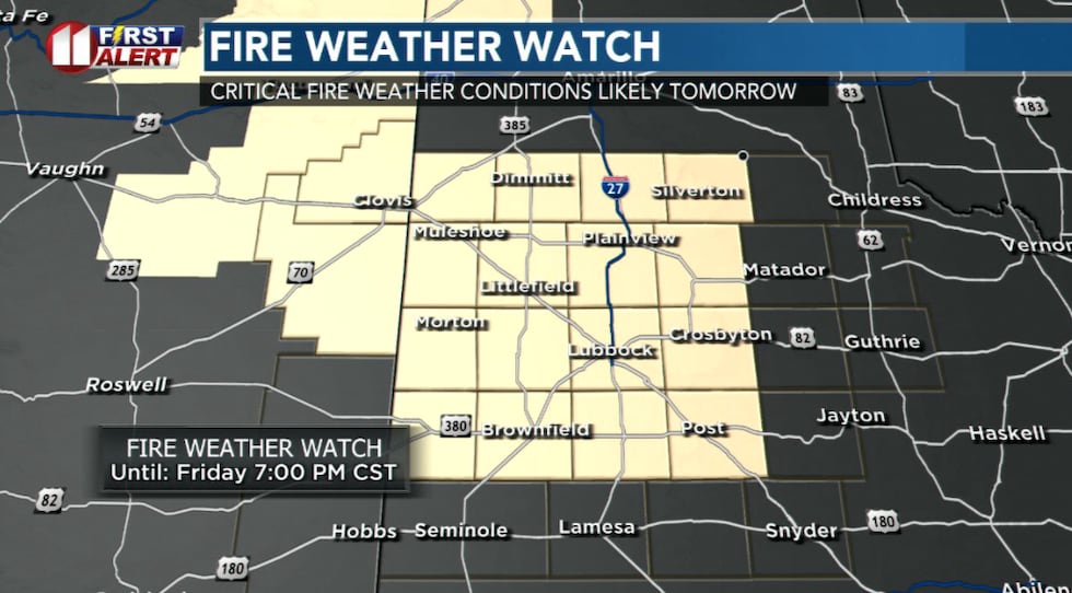
A Fire Weather (aka Red Flag) Warning, issued by the National Weather Service in Lubbock, will be in effect from 10 AM to 7 PM Thursday for entire region except the southern portion of the South Plains and Rolling Plains.
 Thursday afternoon mostly sunny but windy and not as warm.(KCBD First Alert)
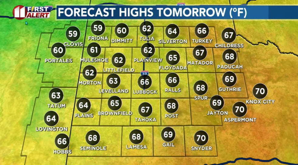
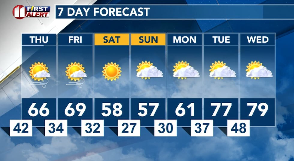
Tomorrow’s weather will include a mix of sun and clouds and a cooler afternoon. Highs tomorrow will be around 5 to 8 degrees cooler than today. That is still around 5 to 8 degrees above average.
More of the Same
The windiest day, other than this past Tuesday, will be Friday. Afternoon winds will increase to 20 to 30 mph with gusts reaching 40 to 45 mph. Once again, secure loose outdoor items, watch for blowing dust that may affect driving conditions, and continue to practice fire safety.
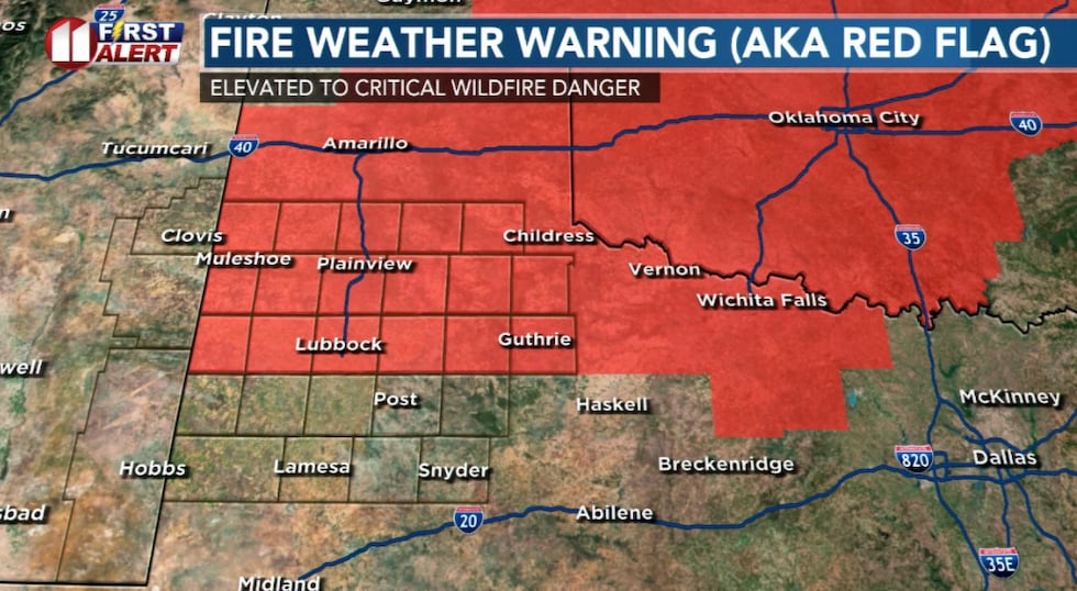
 Critical grassland fire danger anticipated late Friday morning to early Friday evening.(KCBD First Alert)
A Fire Weather Watch, issued by the National Weather Service in Lubbock, will be in effect from 11 AM to 7 PM Friday for areas along and west of the Caprock Escarpment. This includes Lubbock.
Friday otherwise will be mostly sunny with occasional clouds and temperatures peaking mostly in the 60s.
Chilly Weekend
After gusty breezes Friday night, temperatures will take a significant drop. In the Lubbock area lows Friday night will drop to the lower 30s. Lubbock’s average low this time of year is 31 degrees. Mid-20s are possible over the far northwestern viewing area, including the Friona and Muleshoe areas.
 Windy again Thursday and Friday, then less wind but also less warmth this weekend.(KCBD First Alert)
Saturday will be chilly with highs mostly in the 50s, though low 60s are possible in the southern KCBD/FOX34 viewing area.
Saturday night will be the coldest of the weekend and this forecast period. In the Lubbock area lows will dip into the upper 20s. This is cold enough that you should bring in any surviving cold-sensitive plants and check that outdoor pets have access to water and appropriate shelter. Lows in the low 20s are possible over the far northwestern viewing area, including the Friona and Muleshoe areas.
 Gusty winds, and an elevated grassland fire danger, will continue through Friday.(KCBD First Alert)
The lightest winds of the period are expected Sunday. After a cold morning, even with highs mostly in the 50s, you can expect a relatively mild afternoon for the time of year.
Copyright 2026 KCBD. All rights reserved.