
The beautiful weather across Texas this week comes to us courtesy of a ridge of high atmospheric pressure settling over the region.
While we enjoy the sunshine and calm weather, we’re keeping our friends and family in the northeastern United States in mind as they deal with a powerful nor’easter. The storm, which is triggering blizzard and winter storm warnings and snowfall totals of up to two feet along the coast.
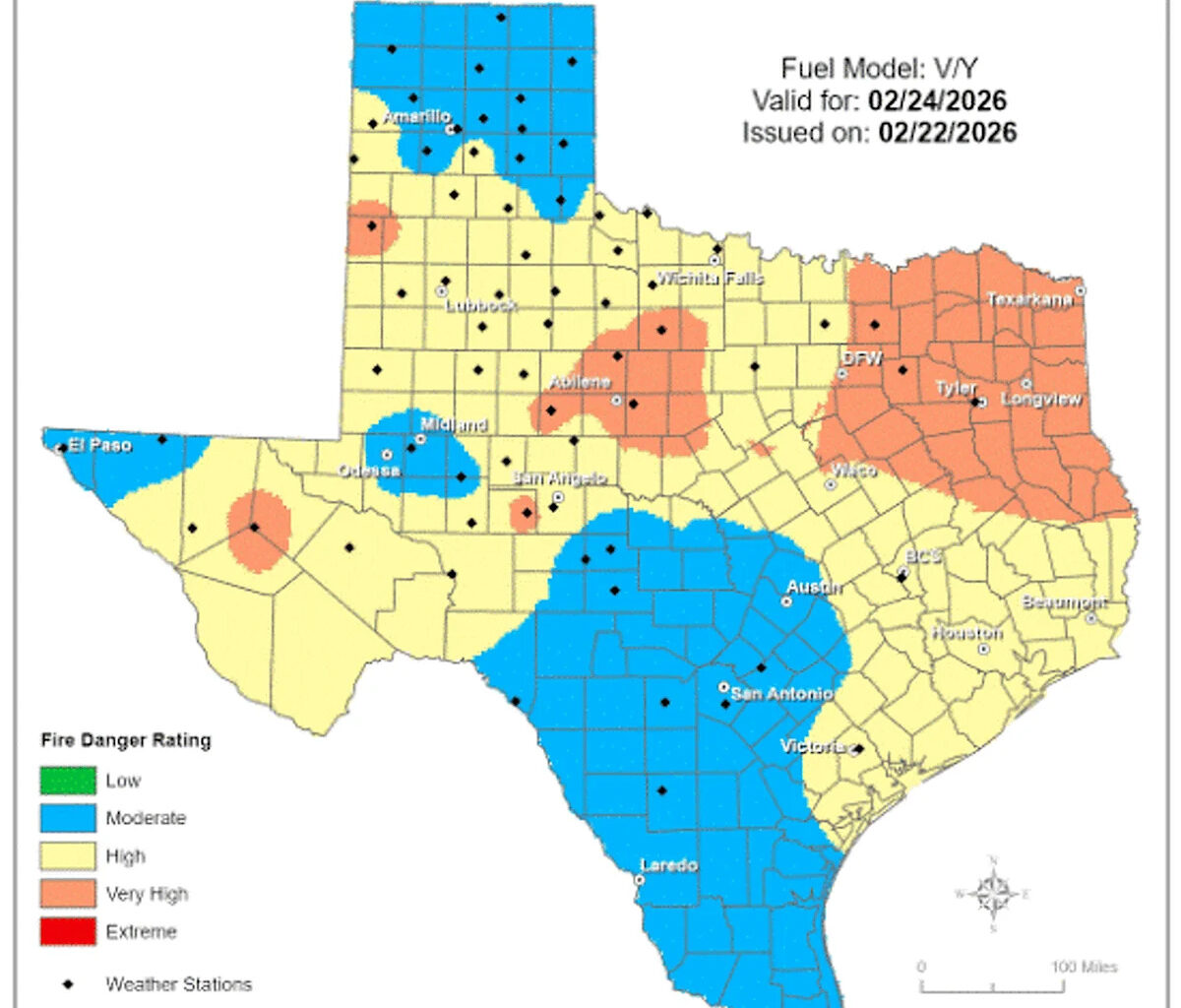
In Texas, our main concern will be an elevated wildfire risk across much of the state by midweek.
Tuesday Forecast
The chilly air from the weekend will stick around for one more morning. While we’re not expecting a widespread freeze like the one Monday morning in the Hill Country, a few low-lying valleys could still fall to near or below freezing — similar to what had happened at Austin-Bergstrom International Airport, which dropped to 28 degrees Monday morning.
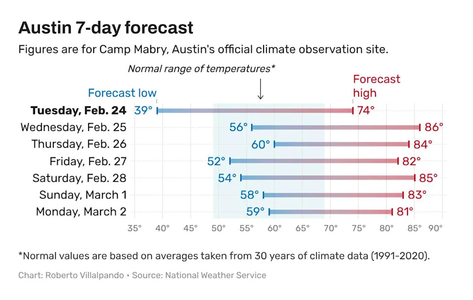
Austin temperatures in the afternoon will be at least 10 degrees above normal over the next several days, even after the passage of a cold front late in the work week. (National Weather Service)
The afternoon will be sunny, warm, and breezy, with south to southwest winds blowing between 8 and 15 mph and gusts near 25 mph. Temperatures will climb into the lower to mid-70s, which is about 5 degrees above our late-February average high temp of 68 degrees.
Moisture will begin to increase throughout the day, as indicated by dew point temperatures steadily rising. But the increase won’t be quite fast enough, which means an elevated wildfire threat will remain across the region.
“By late morning, the winds will be more aggressive, especially over the higher inland terrain,” meteorologists at the National Weather Service wrote in their daily forecast discussion. “We are currently expecting the minimum relative humidity values to bounce back into the 30s, but confidence is below normal that the dew points and relative humidity can get established enough to thwart at least a minor fire weather concern.”
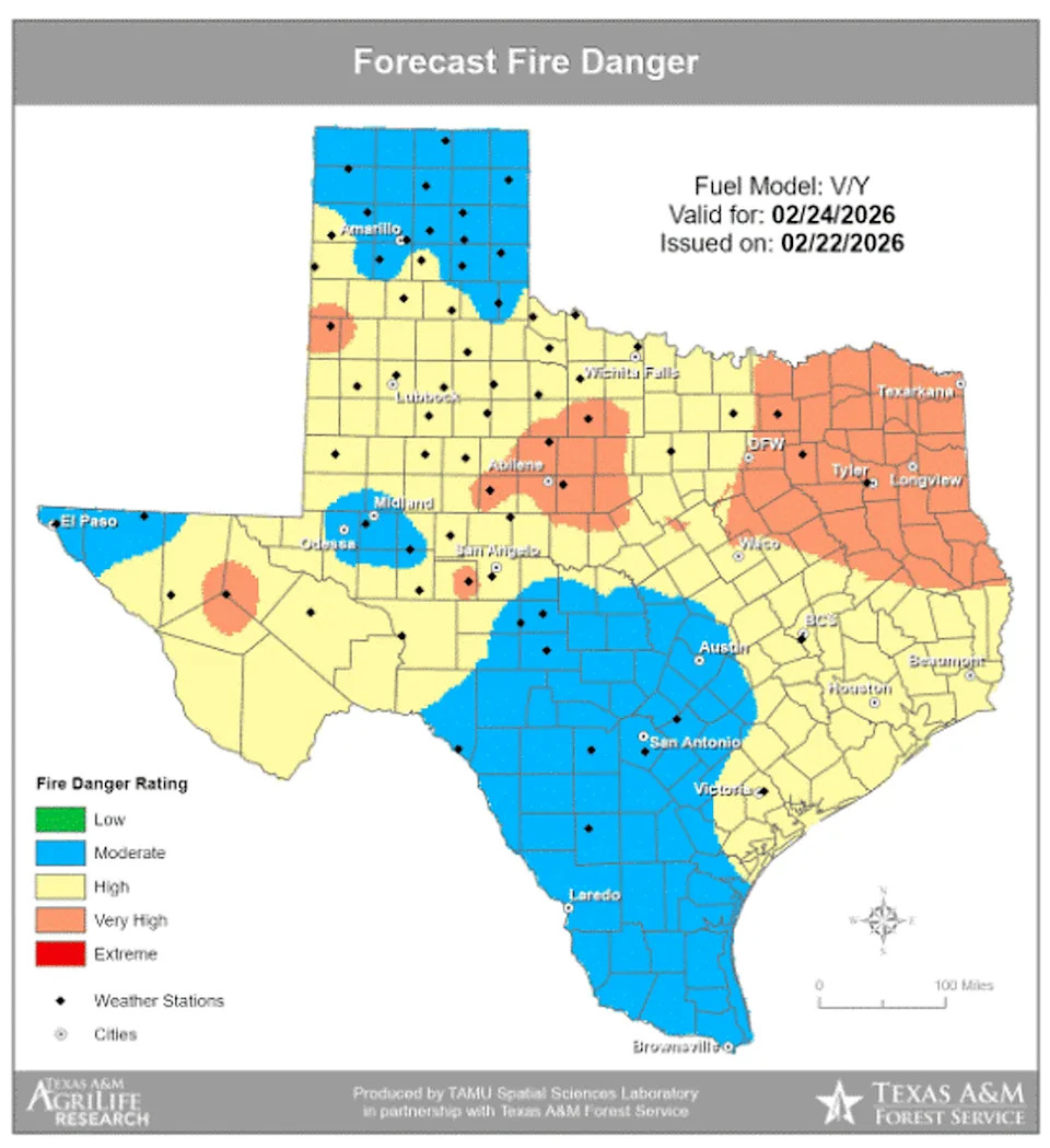
Breezy winds, low humidity, warm temperatures and lots of sunshine will increase the threat of wildfires on Tuesday across parts of Texas. (Texas A&M Forest Service)
The Texas A&M Forest Service is more concerned about the wildfire threat surrounding the Central Texas area. The elevated risk stretches from West Texas into North Texas, then extends east and south toward Houston.
What is the Wednesday forecast?
Southerly air flow off the Gulf Coast will continue Wednesday, which will keep temperatures slightly milder with daybreak temperatures in the upper 40s to lower 50s.
The ridge of high pressure will shift east, and an atmospheric disturbance will move out of the Rocky Mountains, dropping into North Texas. This change in weather features will set up a southwesterly flow across Central Texas, pushing a dry line (between dry and humid air masses) into the region. This will not only elevate fire weather concerns Wednesday, but it will also support a sharp surge in temperatures in Austin. Afternoon highs are expected to climb into the upper 80s, which would be about 10 to 15 degrees warmer than normal.
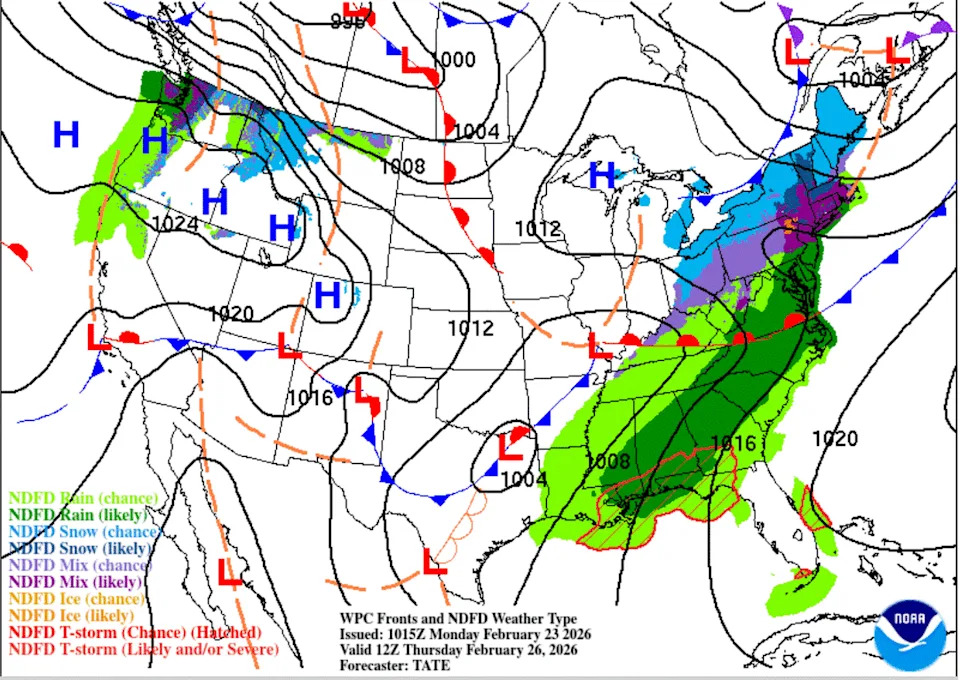
A dry cold front will move across Texas on Thursday, reinforcing the dry air and breezy north winds in place this week. (Weather Prediction Center)
What’s the forecast for the rest of the week?
A cold front will move through around midday Thursday, bringing breezy north winds and a slight dip in temperatures on Friday. However, the air behind the front isn’t especially cold, as the core of the coldest air will remain well to the northeast.
Temperatures will remain above average for late February, even after the front moves through. No rain is expected with this system, and skies will stay mostly clear. Our next opportunity for rain is still several days away and may not arrive until the first weekend of March.