
Wispy cirrus clouds over the Texas Capitol in Austin are spotted on Jan. 9, 2023, the day before the start of the 88th Texas Legislature that year.
Jay Janner
Severe weather season in Texas is just a few weeks away. It’s a time of year when weather can turn dangerous fairly quickly, but you don’t have to be a professional meteorologist to better understand what’s happening in the sky. Simply by observing the clouds each day you can earn scientific knowledge from your own backyard.
Starting a cloud diary or journal is easy and could be a fun project for yourself or your family. Keeping track of cloud types and patterns not only builds a stronger understanding of basic weather concepts but also reveals the direct connection between cloud formations and the changing weather around you.
Article continues below this ad
VISUAL GUIDE TO CLOUDS: Clouds can tell you more about Texas weather than you think.
Keeping a cloud diary that includes cloud types, wind patterns, temperature changes, and precipitation levels can help you learn how to interpret observations and predict weather events. Plus, it’s a great way to impress your friends by forecasting the weather just by “looking up.”
Scattered cumulus clouds fill the sky over Lake Bastrop last year on Sept. 12, 2025, in Bastrop County.
Aaron E. Martinez/Austin American-Statesman
How to begin
St. William Catholic Church in Round Rock appears under thunderstorm clouds blanketing the area in this file photo taken in February 2018.
Ralph Barrera/Austin American-Statesman
To begin your cloud diary, observe the weather each day and document the following elements:
Article continues below this ad
Location and time: Record the date, time, and location of your observation.
Temperature and wind observations: Use your smart phone’s weather app and the nearest airport reporting station to note the temperature, wind direction, and wind speed at the time of observation.
Weather conditions and cloud types: Describe whether it is breezy, sunny, cloudy, stormy, rainy, or foggy, and identify the types of clouds you see.
Visual reference: Either sketch the clouds or take a photograph. You may notice unique cloud formations that tell an even bigger weather story.
This is an excellent introduction to understanding daily weather observations and how they connect to forecasting.
Dark clouds roll into Austin last year on May 28, 2025.
Jay Janner/Austin American-Statesman
For instance, if you observe a sequence in which sunny, dry conditions one day are followed by the appearance of high, thin, wispy clouds, along with a shift to southerly winds and rising temperatures and humidity, it hints at a changing weather pattern.
Article continues below this ad
If, in the following days, increasing moisture and a sticky feel to the atmosphere are accompanied by fog or overcast skies, this can signal the approach of a cold front with a cooler air mass behind it. Such observations suggest that rain or thunderstorms could develop, followed by a northerly wind shift that brings falling temperatures and clearer skies.
Types of clouds
Cirrus clouds: The word cirrus comes from the Latin word “cirro,” which means curl of hair or fringe. Cirrus clouds are found high in the atmosphere where most jet planes fly, between 20,000 and 40,000 feet. Temperatures are well below zero degrees Fahrenheit, so these clouds are formed with ice crystals instead of water droplets. They are white and look wispy.
Cumulus clouds: The Latin word “cumulus” refers to a heap, pile or mound. These clouds are found through all layers of the atmosphere and look like fluffy cotton balls with flat bases. They develop when the moisture, in the form of water droplets, found in rising warm air begins to condense.
Article continues below this ad
Stratus clouds: Stratus comes from the Latin word for “layer” or “spread over.” Stratus clouds form when a large, moist air mass gradually cools as it rises. This cooling causes the water vapor in the air to condense, resulting in a thick, gray layer of clouds that covers the sky, resembling a blanket.
Become a weather spotter
Once you have mastered keeping a cloud diary and documenting weather patterns, you might consider using your skills by joining the National Weather Service’s SKYWARN program, which is a volunteer initiative with more than 350,000 trained weather spotters. According to the National Weather Service, these volunteers play a role in community safety by providing timely and accurate severe weather reports for them.
Article continues below this ad
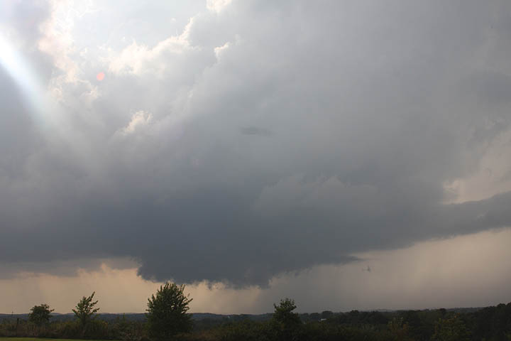
Wall clouds are found underneath the base of a thunderstorm and their presence indicates that the upward motion of air is strong and beginning to rotate.
National Weather Service
Local weather offices offer SKYWARN classes year-round. In these classes, you’ll learn about the basics of thunderstorm development, the fundamentals of storm structure, identifying features of potential severe weather, severe weather safety, what weather information to report, and how to accurately report this information.
To learn more about SKYWARN, visit this website of the National Weather Service office overseeing the San Antonio and Austin areas.