

LUBBOCK, TX (KLBK) — KLBK Chief Meteorologist Jacob Riley has your Monday evening Ag-Journal weather update.
RAINFALL ALMANAC
For both the month of October, Lubbock is sitting at nearly half an inch below average. For 2025 through today’s date, the Hub City is above average for precipitation by 1.24″! By this point of October, we’ve usually received 0.72″ of measurable rainfall in Lubbock. As of October 13, we have received 0.23″, giving us a 0.49″ deficit for the month! When looking at 2025 as a whole, 17.21″ of liquid precipitation has been recorded at Preston Smith International Airport, which is where all official weather records for Lubbock are measured. This puts us 1.24″ above the average annual rainfall amount at this point in the year of 15.97″!
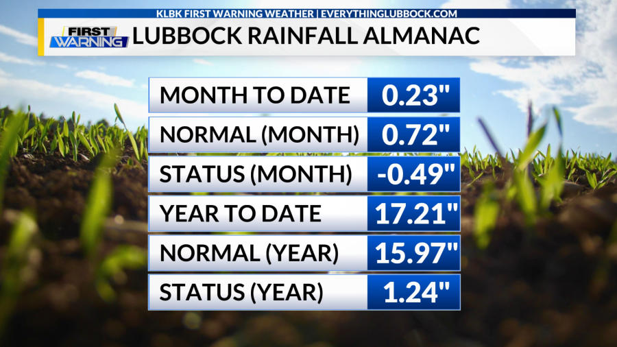 Lubbock Rainfall Almanac | Valid Monday, October 13, 2025
PRECIPITATION STATS
Over the past 30 calendar days, we have seen relatively dry conditions around most of the region. The percent of average image below (bottom left) shows that areas shaded in green, blue, and gray have received average or above average rainfall over the past 30 calendar days. Areas in yellow, orange, and red have seen less than average rainfall for the exact same timeframe. The rainfall deficit graphic below (bottom right) puts an actual number rather than a percentage on how far behind rainfall totals are for some. Anywhere on this image that is shaded has seen less than average rainfall over the past 30 calendar days.
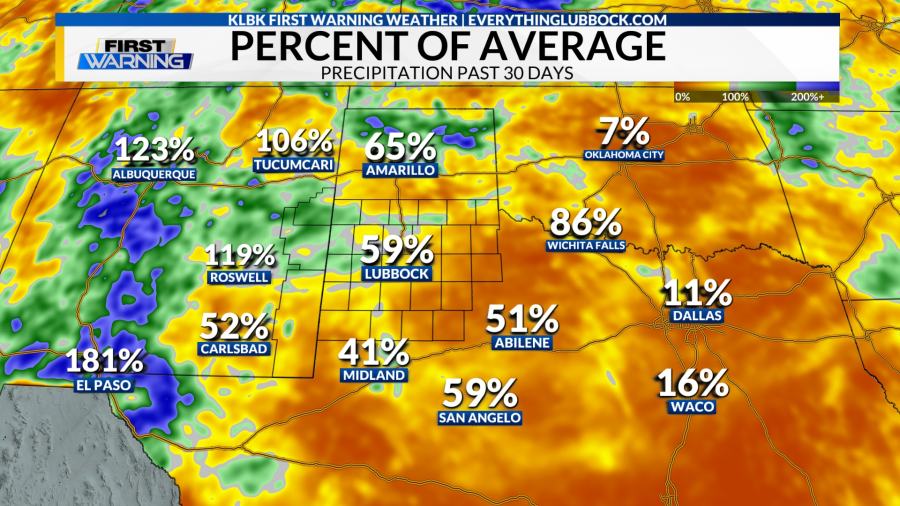 Percent of Average Received Over the Past 30 Days
Valid Monday, October 13, 2025
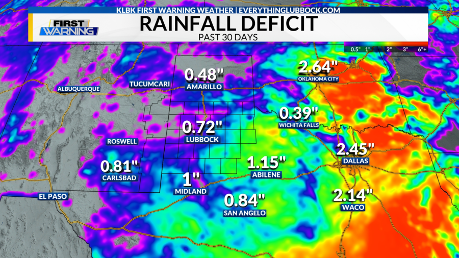 Rainfall Deficit Over the Past 30 Days
Valid Monday, October 13, 2025
DROUGHT UPDATE:
Only level D1 moderate drought is being reported across the South Plains and the Rolling Plains, according to the latest update of the U.S. Drought Monitor (USDM) released on Thursday, October 9, 2025. Moderate stage (D1) drought conditions and abnormally dry (D0) status were reported across the Rolling Plains, southern Texas Panhandle, and southeastern New Mexico. Over the next several weeks, drought conditions are expected to continue to worsen across a majority of the region.
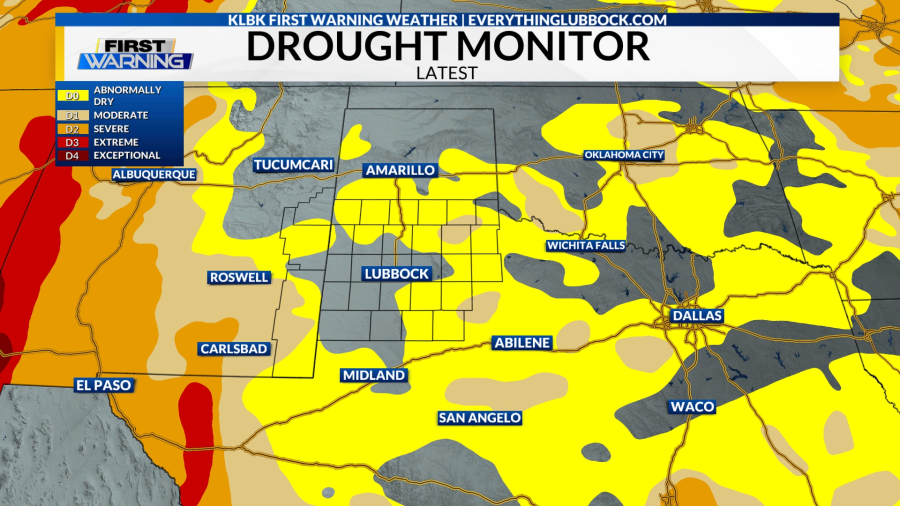 Latest U.S. Drought Monitor Update | Valid: October 13, 2025
RAINFALL OUTLOOK NEXT 7 DAYS
Not much in the way of rainfall is expected across eastern New Mexico or western Texas over the next week. Isolated showers will be possible across eastern New Mexico and the Texas Panhandle through Tuesday. Aside from that, we will most likely remain dry across the region over the next 7 day period.
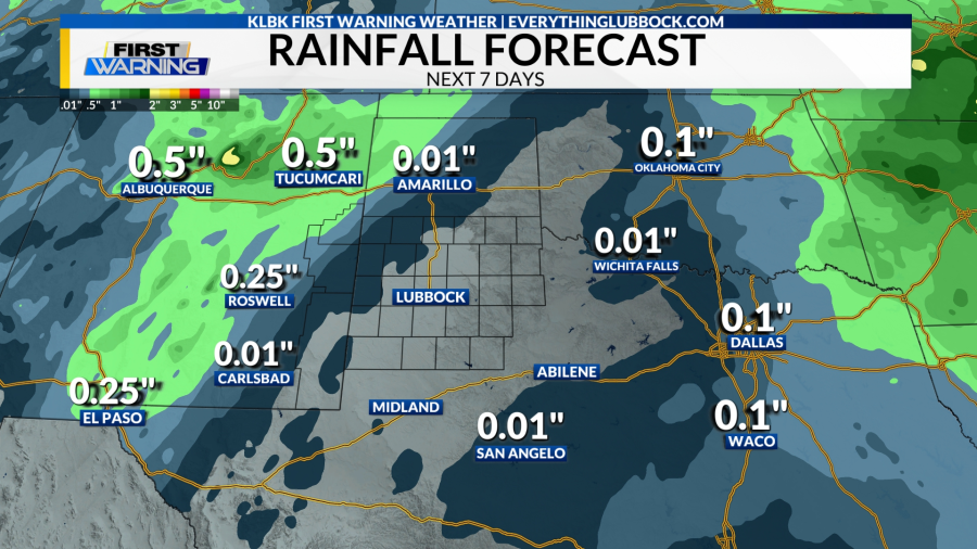 7-Day Rainfall Forecast | Valid: October 13, 2025
5-DAY FORECAST
Over the next five days, temperatures are expected to remain above average. Highs will peak in the 80s to low 90s, with morning lows in the 50s and 60s. We will remain mostly dry, with the possibility of a stray shower or two hanging around through Friday. Rainfall coverage looks to remain at or below 10% of the KLBK forecast area. This is good news for active harvest, as fields will not be too wet for equipment to get into. Winds will be breezy at times, mainly out of the south. Sustained speeds of 10-20 MPH will be accompanied by occasional gusts of 30-40 MPH. Winds will briefly shift to the northwest on Saturday as a weak ‘cold’ front moves into the region. Relative humidity values look to be at or below 45% from Noon through 7 PM Tuesday and Wednesday, with RH values at or below 45% from roughly sunrise through midnight Thursday through Saturday.
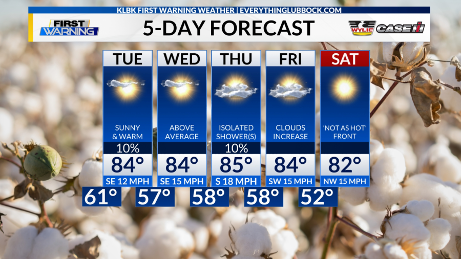 KLBK 5-Day Ag-Journal Forecast | Valid: October 13, 2024
EXTENDED OUTLOOK | DAYS 6-14
Temperatures look to remain above average for both the 6-10 and 8-14 day timeframes, which run October 19-27, 2025. Our average high and low temperatures for those dates are around 74° and 45° for the city of Lubbock. There is currently a 50%-70% chance for us to see temperatures above these averages through the respective timeframes.
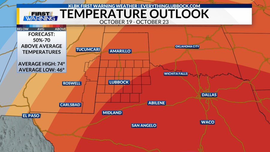 6-10 Day Temperature Trend Outlook
Valid Monday, October 13, 2025
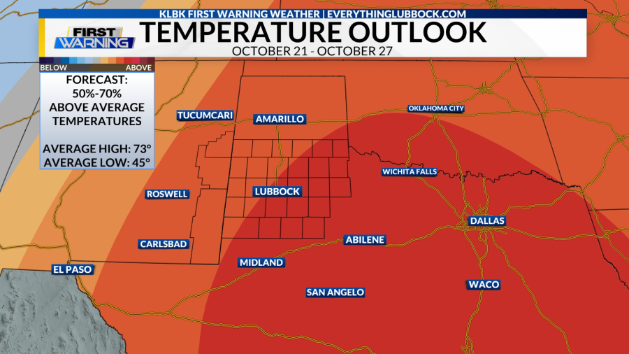 8-14 Day Temperature Trend Outlook
Valid Monday, October 13, 2025
Precipitation trends are signaling that we could see close to average rainfall around the region. Eastern areas could see slightly above average precipitation. Our average rain total in Lubbock for these timeframes is 0.56″. There is currently a 0%-30% chance we will see rainfall totals more than this over the next 6-14 day period.
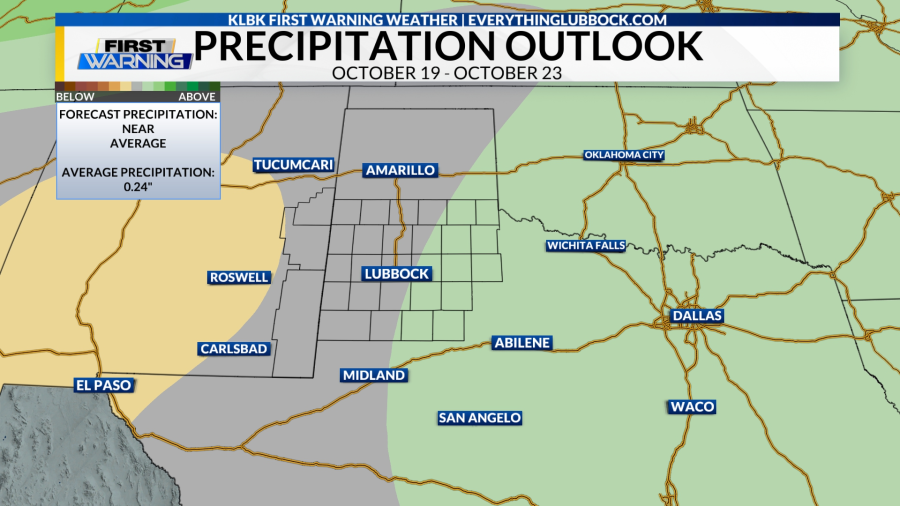 6-10 Day Precipitation Trend Outlook
Valid Monday, October 13, 2025
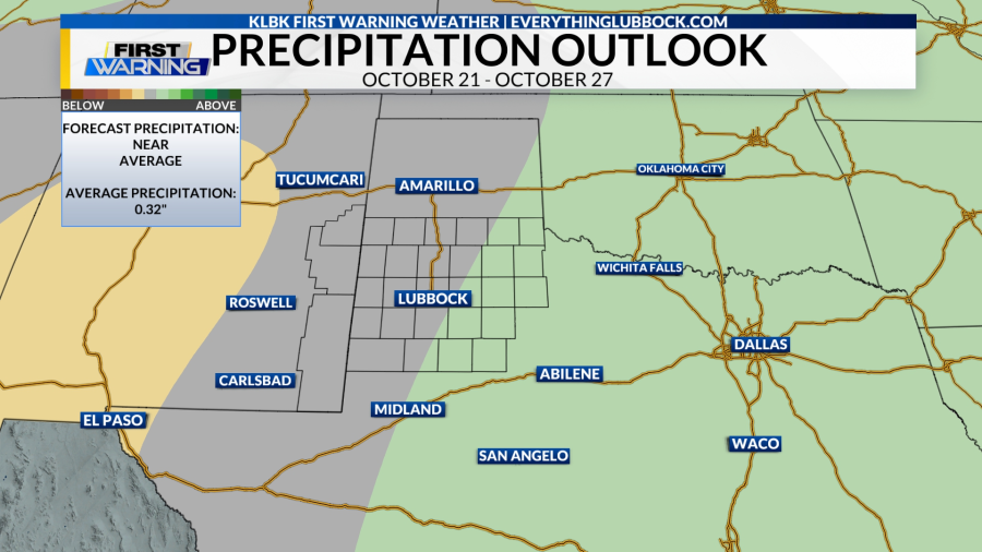 8-14 Day Precipitation Trend Outlook
Valid Monday, October 13, 2025
As always, you can stay up to date with the latest information on Facebook, X, or on our website at everythinglubbock.com/klbk-weather/. If you don’t have it yet, make sure to download our new and improved EverythingLubbock Weather app. It is free in both the Google Play and Apple App stores. Also, remember to download our new ‘EL+’ connected TV app! It’s a 24-hour LIVE channel with exclusive local content for your viewing. Just search ‘el plus’ on your Roku, Amazon Fire Stick, or search ‘KLBK’ on your Apple TV!
Lubbock Climate Data for Monday, October 13, 2025:
Sunrise: 7:51 AM CDT
Sunset: 7:15 PM CDT
Average High: 77°
Average Low: 49°
Record High: 92° (1989 & 1992)
Record Low: 28° (1969)
Have a terrific Tuesday, South Plains!
-Jacob
Facebook: Chief Meteorologist Jacob Riley KLBK
X: @jrileywx