
LUBBOCK, Texas (KCBD) – A total lunar eclipse will be visible from the KCBD/FOX34 viewing area late tonight, but viewing conditions are will be iffy. Cloud cover may prevent a clear view of the moon during the eclipse.
When to Look Up
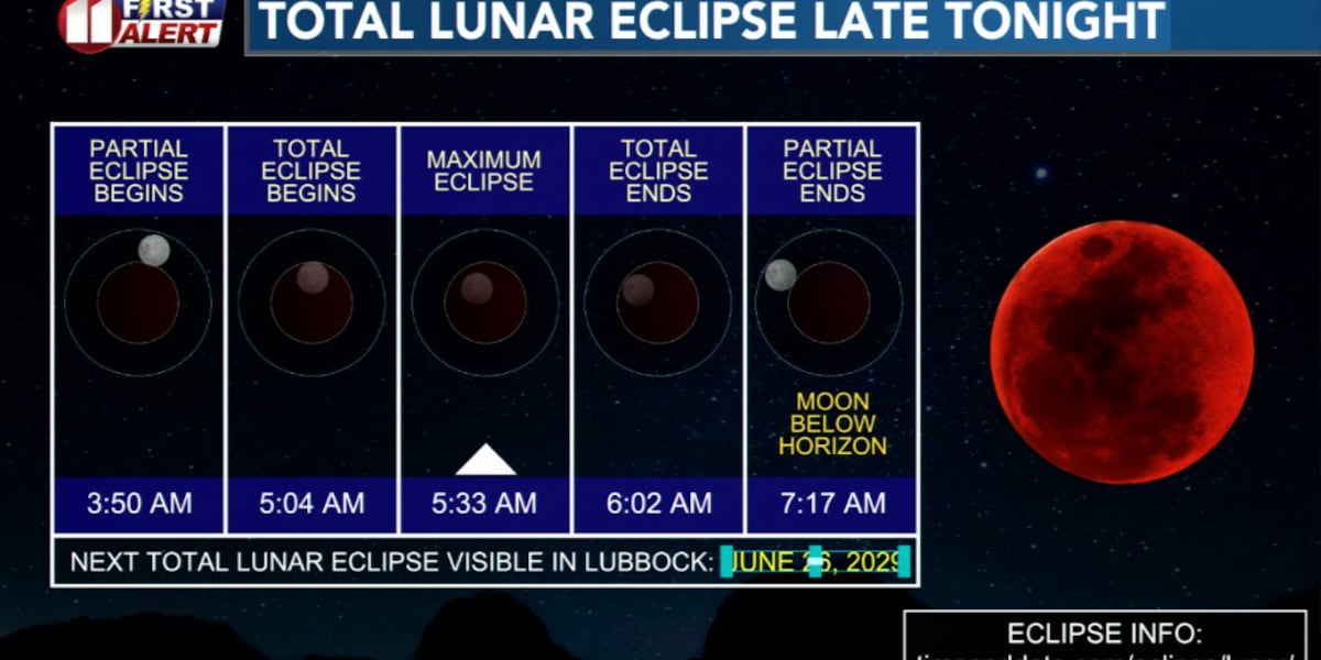
The moon will enter totality, when the moon is in the darkest part of Earths’ shadow, at 5:04 AM CST. Maximum totality is at 5:33 AM. Totality will end at 6:02 AM CST Tuesday morning. If you’re planning to wake up early to catch this rare celestial event, set your alarm and head outside with your camera or binoculars ready — but keep an eye on the clouds.
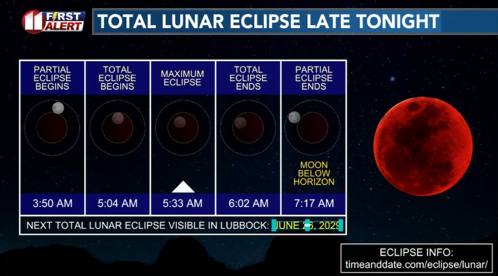 Totality, when the moon is in the darkest part of Earths’ shadow, is from 5:04 AM to 6:02 AM CST Monday morning.(KCBD First Alert)
We won’t be able to view another total lunar eclipse from the Lubbock area for more than three years.
Tonight’s Conditions
The clouds are the main concern for eclipse viewing, but if you do venture outside take along warm clothing and give your eyes a good ten minutes to fully adjust to the dark. Clouds may come and go with a low around 51°F. Winds will be light to moderate from the south at 8 to 18 mph.
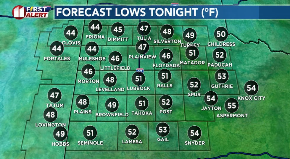 Chilly but mild overnight temperatures. For the time of year.(KCBD First Alert)
For the best view, avoid the lights of the city.
Warming Tomorrow
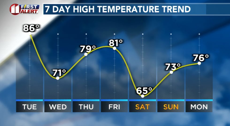
After the eclipse, our area will warm up significantly. Tuesday will start cloudy but clear to mostly sunny during the afternoon. Temperatures will peak 20 to 25 degrees above average for early March.
Winds will pick up, from the southwest, at around 10 to 20 mph with gusts near 30 mph. With the wind and warmth, Tuesday is a NO BURN DAY.
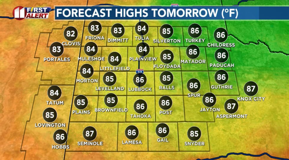 Tuesday afternoon temperatures will peak 20 to 25 degrees above average for early March.(KCBD First Alert)
Then Chilly
Tuesday night will turn chilly under a partly cloudy sky. However, lows will be nearly ten degrees above average.
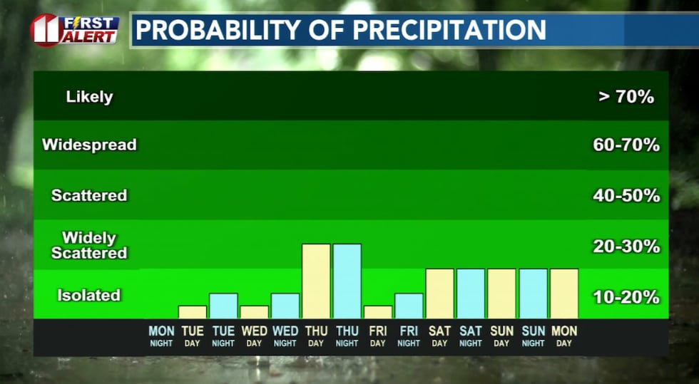
There is only a slight chance of rain, and that is mainly over the eastern half of the KCBD/FOX34 viewing area.
Then Cool
 Temperatures will range from the 60s to the 80s, but even on the coolest days highs will not dip below average.(KCBD First Alert)
Wednesday will be mostly cloudy with highs ranging from the upper 60s to low 70s.
Storm Potential
Thursday brings intervals of clouds and sunshine with a slight chance of afternoon and evening thunderstorms.
Highs from the mid-70s to near 80 are expected. It will be quite breeze to somewhat windy, at 15 to 25 mph and gusts near 35 mph possible. Stronger gusts are possible in the vicinity of any storms that develop.
 There are several opportunities for rain this week.(KCBD First Alert)
Thursday night continues the storm chance, though mainly over the eastern viewing area. Some storms may be strong, so stay weather aware.
Friday looks dry, breezy, and warmer. It will be another NO BURN DAY across West Texas and eastern New Mexico.
Weekend Outlook
The weekend will start mostly cloudy Friday night, which will get chilly with lows in the 40s.
Saturday through Sunday will be mostly cloudy with a slight chance of rain.
Lose An Hour
Here’s an important reminder. Daylight Saving Time begins this Saturday night. Time springs forward one hour. 2 AM CST becomes 3 AM CDT.
On This Date
On this date in 2008, a powerful winter storm brought a combination of high winds and winter weather, including accumulating snowfall, to the West Texas South Plains region. The strong northerly winds destroyed a metal storage shed when it was blown through a fence in Muleshoe
and snapped a power pole in Childress. Blowing snow at times significantly reduced visibility to near blizzard conditions. This contributed to at least two dozen automobile accidents across the
region. Injuries were reported as a result of accidents in Castro and Hockley Counties.
(Source: National Weather Service, Lubbock)
Copyright 2026 KCBD. All rights reserved.